Blind Bull Creek Topo Map Wyoming
To zoom in, hover over the map of Blind Bull Creek
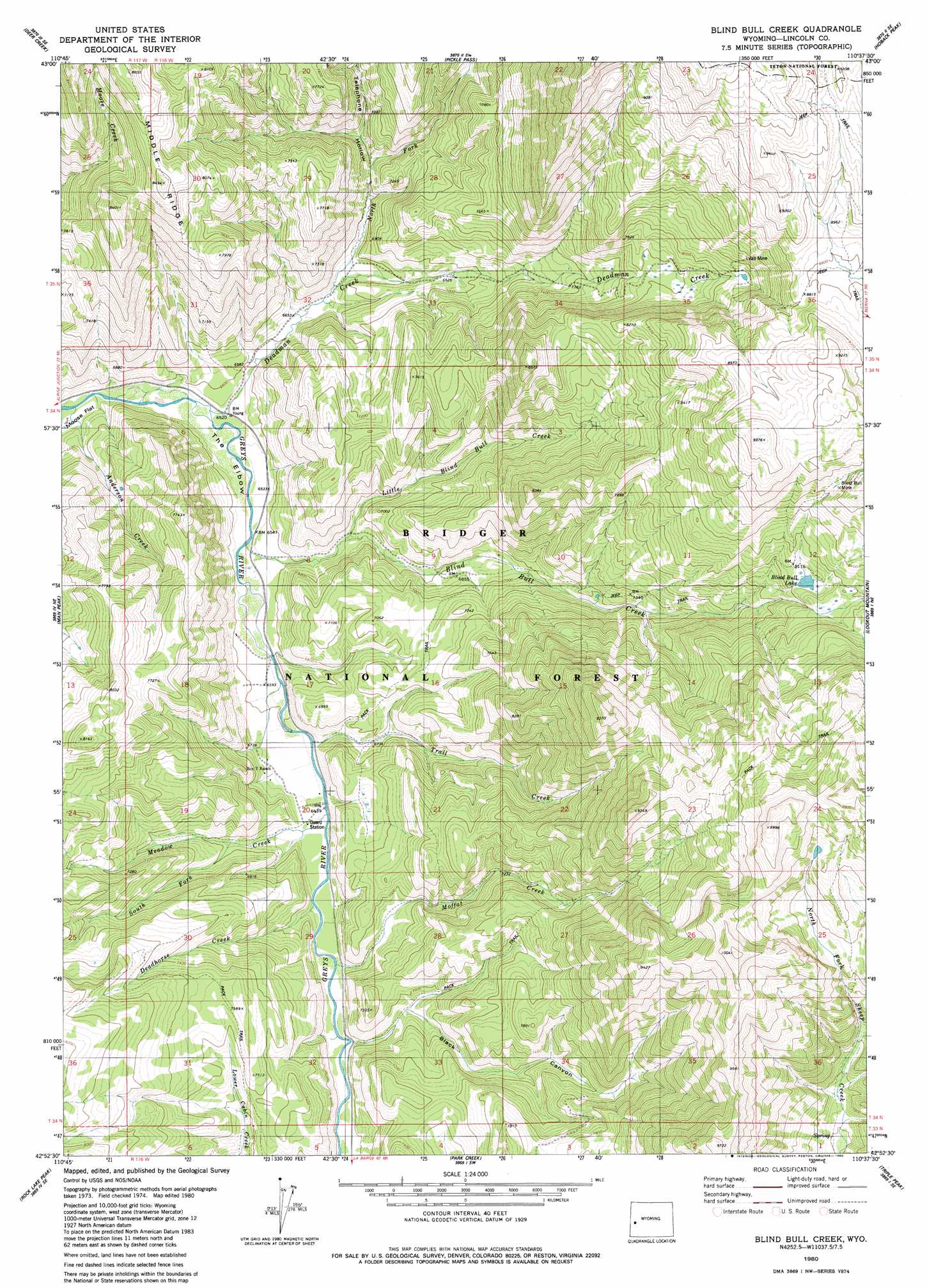
USGS Topo Quad 42110h6 - 1:24,000 scale
| Topo Map Name: | Blind Bull Creek |
| USGS Topo Quad ID: | 42110h6 |
| Print Size: | ca. 21 1/4" wide x 27" high |
| Southeast Coordinates: | 42.875° N latitude / 110.625° W longitude |
| Map Center Coordinates: | 42.9375° N latitude / 110.6875° W longitude |
| U.S. State: | WY |
| Filename: | o42110h6.jpg |
| Download Map JPG Image: | Blind Bull Creek topo map 1:24,000 scale |
| Map Type: | Topographic |
| Topo Series: | 7.5´ |
| Map Scale: | 1:24,000 |
| Source of Map Images: | United States Geological Survey (USGS) |
| Alternate Map Versions: |
Blind Bull Creek WY 1980, updated 1980 Download PDF Buy paper map Blind Bull Creek WY 1980, updated 1980 Download PDF Buy paper map Blind Bull Creek WY 2012 Download PDF Buy paper map Blind Bull Creek WY 2015 Download PDF Buy paper map |
| FStopo: | US Forest Service topo Blind Bull Creek is available: Download FStopo PDF Download FStopo TIF |
1:24,000 Topo Quads surrounding Blind Bull Creek
Ferry Peak |
Pine Creek |
Bailey Lake |
Clause Peak |
Bondurant |
Stewart Peak |
Deer Creek |
Pickle Pass |
Hoback Peak |
Noble Basin |
Thayne East |
Man Peak |
Blind Bull Creek |
Lookout Mountain |
Prospect Peak |
Grover |
Rock Lake Peak |
Park Creek |
Triple Peak |
Maki Creek |
Afton |
Red Top Mountain |
Box Canyon Creek |
Mount Schidler |
Red Castle Creek |
> Back to 42110e1 at 1:100,000 scale
> Back to 42110a1 at 1:250,000 scale
> Back to U.S. Topo Maps home
Blind Bull Creek topo map: Gazetteer
Blind Bull Creek: Bends
The Elbow elevation 1988m 6522′Blind Bull Creek: Lakes
Blind Bull Lake elevation 2454m 8051′Blind Bull Creek: Mines
Alpine Mine elevation 2699m 8854′Blind Bull Mine elevation 2702m 8864′
Deadman Gulch Mine elevation 2551m 8369′
Old Blind Bull Mine elevation 2621m 8599′
Vail Mine elevation 2529m 8297′
West Mine elevation 2215m 7267′
Blind Bull Creek: Streams
Anderson Creek elevation 1970m 6463′Blind Bull Creek elevation 2000m 6561′
Deadhorse Creek elevation 2033m 6669′
Deadman Creek elevation 1995m 6545′
Henderson Creek elevation 1971m 6466′
Little Blind Bull Creek elevation 2038m 6686′
Meadow Creek elevation 2023m 6637′
Moffat Creek elevation 2054m 6738′
North Fork Deadman Creek elevation 2049m 6722′
South Fork Meadow Creek elevation 2060m 6758′
Blind Bull Creek: Valleys
Black Canyon elevation 2072m 6797′Telephone Hollow elevation 2047m 6715′
Blind Bull Creek digital topo map on disk
Buy this Blind Bull Creek topo map showing relief, roads, GPS coordinates and other geographical features, as a high-resolution digital map file on DVD: