Boundary Ridge Topo Map Idaho
To zoom in, hover over the map of Boundary Ridge
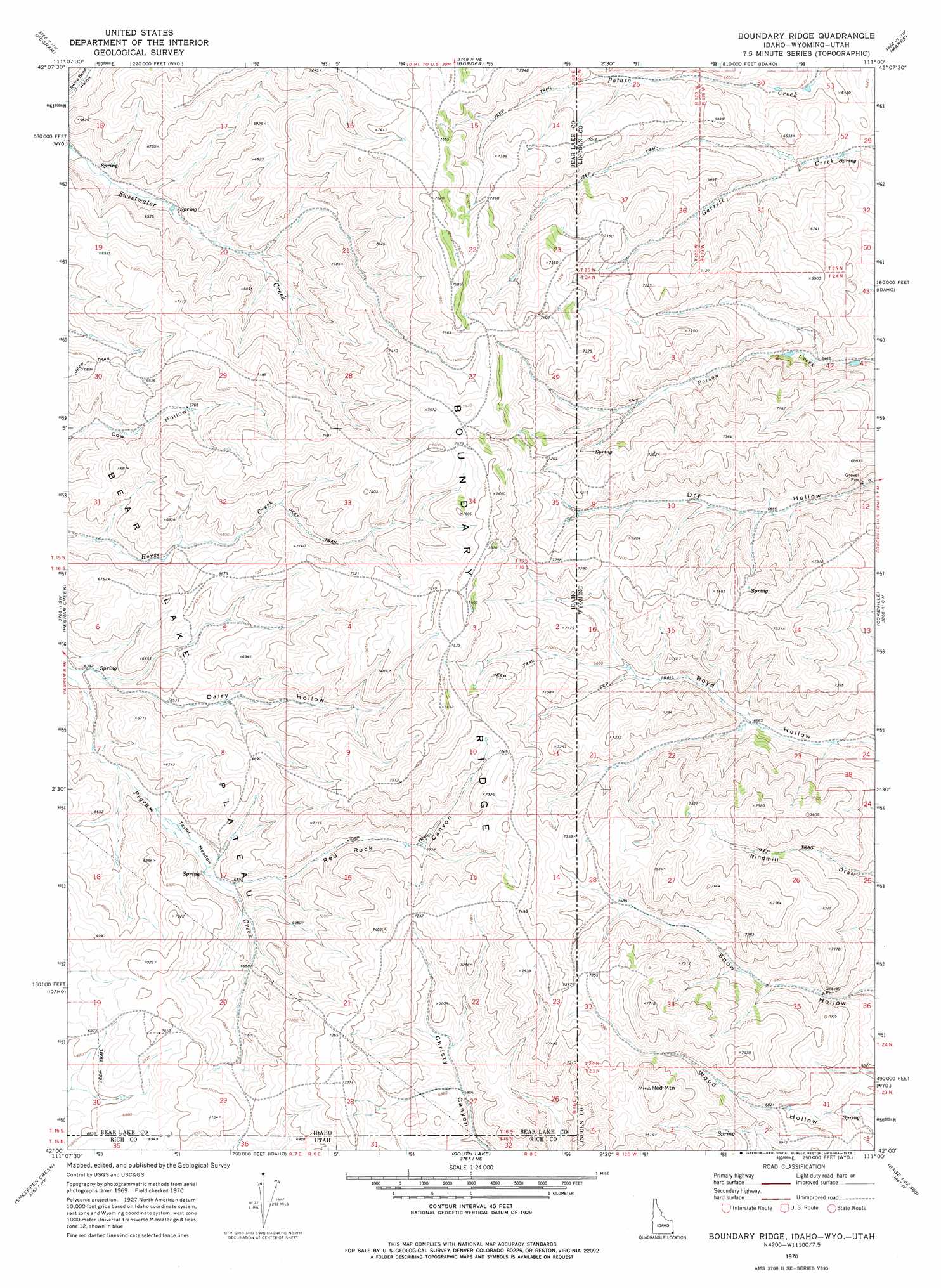
USGS Topo Quad 42111a1 - 1:24,000 scale
| Topo Map Name: | Boundary Ridge |
| USGS Topo Quad ID: | 42111a1 |
| Print Size: | ca. 21 1/4" wide x 27" high |
| Southeast Coordinates: | 42° N latitude / 111° W longitude |
| Map Center Coordinates: | 42.0625° N latitude / 111.0625° W longitude |
| U.S. States: | ID, UT, WY |
| Filename: | o42111a1.jpg |
| Download Map JPG Image: | Boundary Ridge topo map 1:24,000 scale |
| Map Type: | Topographic |
| Topo Series: | 7.5´ |
| Map Scale: | 1:24,000 |
| Source of Map Images: | United States Geological Survey (USGS) |
| Alternate Map Versions: |
Boundary Ridge ID 1970, updated 1973 Download PDF Buy paper map Boundary Ridge ID 2011 Download PDF Buy paper map Boundary Ridge ID 2013 Download PDF Buy paper map |
1:24,000 Topo Quads surrounding Boundary Ridge
Montpelier |
Montpelier Canyon |
Geneva |
Huff Lake |
Big Park |
Dingle |
Pegram |
Border |
Marse |
Nugent Park |
Bear Lake North |
Pegram Creek |
Boundary Ridge |
Cokeville |
Sublette Canyon |
Bear Lake South |
Sheeppen Creek |
South Lake |
Beckwith |
The Rock Slide |
Laketown |
Sage Creek |
Leefe |
Sage |
Nugget |
> Back to 42111a1 at 1:100,000 scale
> Back to 42110a1 at 1:250,000 scale
> Back to U.S. Topo Maps home
Boundary Ridge topo map: Gazetteer
Boundary Ridge: Dams
Poison Creek Dam elevation 1957m 6420′Boundary Ridge: Reservoirs
Poison Creek Reservoir elevation 1957m 6420′Boundary Ridge: Ridges
Boundary Ridge elevation 2330m 7644′Boundary Ridge: Streams
Garrett Creek elevation 1913m 6276′Poison Creek elevation 1941m 6368′
Potato Creek elevation 1922m 6305′
Boundary Ridge: Summits
Red Mountain elevation 2345m 7693′Boundary Ridge: Valleys
Dairy Hollow elevation 1954m 6410′Dry Hollow elevation 1969m 6459′
Red Rock Canyon elevation 2010m 6594′
Snow Hollow elevation 1995m 6545′
Wood Hollow elevation 1978m 6489′
Boundary Ridge digital topo map on disk
Buy this Boundary Ridge topo map showing relief, roads, GPS coordinates and other geographical features, as a high-resolution digital map file on DVD: