Riverdale Topo Map Idaho
To zoom in, hover over the map of Riverdale
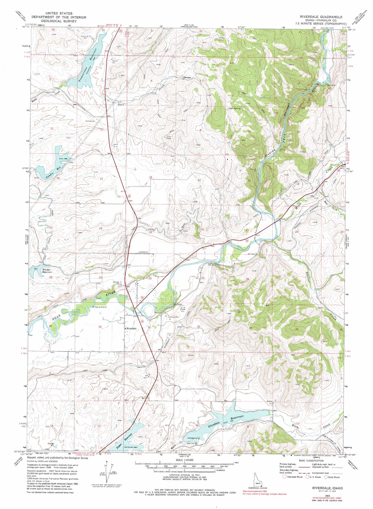
USGS Topo Quad 42111b7 - 1:24,000 scale
| Topo Map Name: | Riverdale |
| USGS Topo Quad ID: | 42111b7 |
| Print Size: | ca. 21 1/4" wide x 27" high |
| Southeast Coordinates: | 42.125° N latitude / 111.75° W longitude |
| Map Center Coordinates: | 42.1875° N latitude / 111.8125° W longitude |
| U.S. State: | ID |
| Filename: | o42111b7.jpg |
| Download Map JPG Image: | Riverdale topo map 1:24,000 scale |
| Map Type: | Topographic |
| Topo Series: | 7.5´ |
| Map Scale: | 1:24,000 |
| Source of Map Images: | United States Geological Survey (USGS) |
| Alternate Map Versions: |
Riverdale ID 1969, updated 1973 Download PDF Buy paper map Riverdale ID 1969, updated 1986 Download PDF Buy paper map Riverdale ID 2010 Download PDF Buy paper map Riverdale ID 2013 Download PDF Buy paper map |
1:24,000 Topo Quads surrounding Riverdale
Downey East |
Cottonwood Peak |
Thatcher Hill |
Thatcher |
North Canyon |
Oxford |
Swan Lake |
Treasureton |
Oneida Narrows Reservoir |
Midnight Mountain |
Clifton |
Banida |
Riverdale |
Mink Creek |
Paris Peak |
Weston Canyon |
Weston |
Franklin |
Mapleton |
Egan Basin |
Clarkston |
Trenton |
Richmond |
Naomi Peak |
Tony Grove Creek |
> Back to 42111a1 at 1:100,000 scale
> Back to 42110a1 at 1:250,000 scale
> Back to U.S. Topo Maps home
Riverdale topo map: Gazetteer
Riverdale: Areas
Falls elevation 1380m 4527′Riverdale: Canals
Preston Riverdale Canal elevation 1499m 4917′Twin Lakes Canal elevation 1498m 4914′
Riverdale: Dams
Condie Dam elevation 1490m 4888′Glendale Dam elevation 1506m 4940′
Strongarm Reservoir Number One Dam elevation 1515m 4970′
Riverdale: Populated Places
Riverdale elevation 1389m 4557′Riverdale: Reservoirs
Condie Reservoir elevation 1490m 4888′Glendale Reservoir elevation 1506m 4940′
Strongarm Reservoir Number One elevation 1513m 4963′
Treasureton Reservoir elevation 1515m 4970′
Riverdale: Springs
Cold Spring elevation 1727m 5666′Riverdale: Streams
Bear Creek elevation 1433m 4701′Mink Creek elevation 1408m 4619′
Sant Creek elevation 1513m 4963′
Station Creek elevation 1406m 4612′
Riverdale: Valleys
Oneida Narrows elevation 1421m 4662′Riverdale digital topo map on disk
Buy this Riverdale topo map showing relief, roads, GPS coordinates and other geographical features, as a high-resolution digital map file on DVD: