Oneida Narrows Reservoir Topo Map Idaho
To zoom in, hover over the map of Oneida Narrows Reservoir
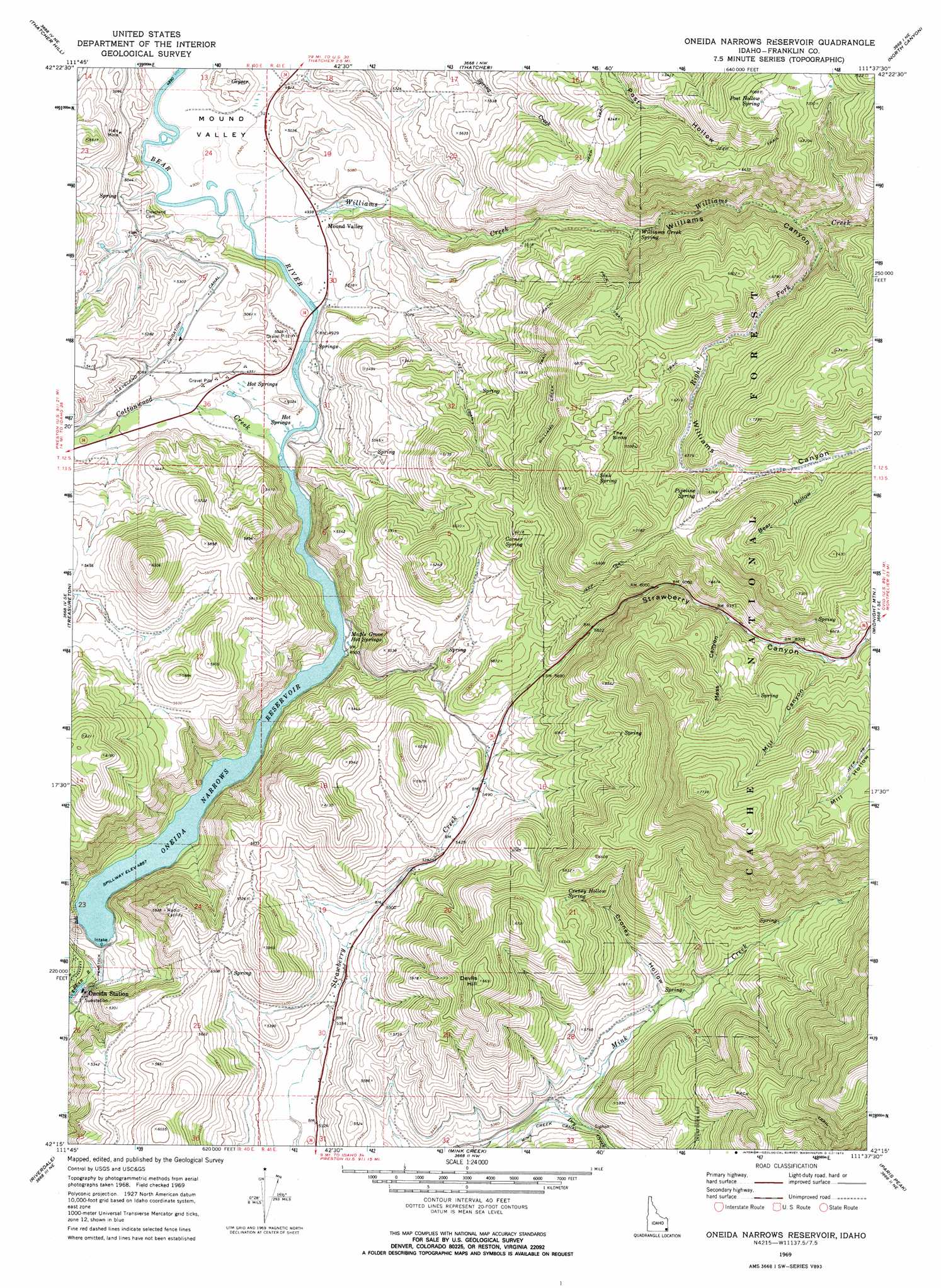
USGS Topo Quad 42111c6 - 1:24,000 scale
| Topo Map Name: | Oneida Narrows Reservoir |
| USGS Topo Quad ID: | 42111c6 |
| Print Size: | ca. 21 1/4" wide x 27" high |
| Southeast Coordinates: | 42.25° N latitude / 111.625° W longitude |
| Map Center Coordinates: | 42.3125° N latitude / 111.6875° W longitude |
| U.S. State: | ID |
| Filename: | o42111c6.jpg |
| Download Map JPG Image: | Oneida Narrows Reservoir topo map 1:24,000 scale |
| Map Type: | Topographic |
| Topo Series: | 7.5´ |
| Map Scale: | 1:24,000 |
| Source of Map Images: | United States Geological Survey (USGS) |
| Alternate Map Versions: |
Oneida Narrows Reservoir ID 1969, updated 1973 Download PDF Buy paper map Oneida Narrows Reservoir ID 2005, updated 2007 Download PDF Buy paper map Oneida Narrows Reservoir ID 2011 Download PDF Buy paper map Oneida Narrows Reservoir ID 2013 Download PDF Buy paper map |
| FStopo: | US Forest Service topo Oneida Narrows Reservoir is available: Download FStopo PDF Download FStopo TIF |
1:24,000 Topo Quads surrounding Oneida Narrows Reservoir
Sedgwick Peak |
Grace Power Plant |
Grace |
Soda Peak |
Fossil Canyon |
Cottonwood Peak |
Thatcher Hill |
Thatcher |
North Canyon |
Nounan |
Swan Lake |
Treasureton |
Oneida Narrows Reservoir |
Midnight Mountain |
Ovid |
Banida |
Riverdale |
Mink Creek |
Paris Peak |
Paris |
Weston |
Franklin |
Mapleton |
Egan Basin |
Saint Charles |
> Back to 42111a1 at 1:100,000 scale
> Back to 42110a1 at 1:250,000 scale
> Back to U.S. Topo Maps home
Oneida Narrows Reservoir topo map: Gazetteer
Oneida Narrows Reservoir: Basins
The Sinks elevation 2006m 6581′Oneida Narrows Reservoir: Bridges
McGregors Bridge elevation 1494m 4901′Oneida Narrows Reservoir: Canals
Cleveland Irrigation Canal elevation 1564m 5131′Oneida Narrows Reservoir: Dams
Oneida Dam elevation 1486m 4875′Oneida Narrows Reservoir: Populated Places
Cleveland elevation 1511m 4957′Mound Valley elevation 1510m 4954′
Oneida Narrows Reservoir: Reservoirs
Oneida Narrows Reservoir elevation 1486m 4875′Oneida Narrows Reservoir: Springs
Corner Spring elevation 1850m 6069′Croney Hollow Spring elevation 1885m 6184′
Maple Grove Hot Springs elevation 1498m 4914′
Pipeline Spring elevation 2009m 6591′
Post Hollow Spring elevation 2146m 7040′
Sink Spring elevation 1990m 6528′
Williams Creek Spring elevation 1704m 5590′
Oneida Narrows Reservoir: Streams
Cottonwood Creek elevation 1493m 4898′Dry Creek elevation 1609m 5278′
Right Fork Williams Creek elevation 1863m 6112′
Williams Creek elevation 1495m 4904′
Oneida Narrows Reservoir: Summits
Devils Hill elevation 2040m 6692′Oneida Narrows Reservoir: Valleys
Bear Hollow elevation 1996m 6548′Croney Hollow elevation 1669m 5475′
Mass Canyon elevation 1878m 6161′
Mill Canyon elevation 1942m 6371′
Mill Hollow elevation 1995m 6545′
Mound Valley elevation 1491m 4891′
Strawberry Canyon elevation 1734m 5688′
Williams Canyon elevation 1552m 5091′
Oneida Narrows Reservoir digital topo map on disk
Buy this Oneida Narrows Reservoir topo map showing relief, roads, GPS coordinates and other geographical features, as a high-resolution digital map file on DVD: