North Canyon Topo Map Idaho
To zoom in, hover over the map of North Canyon
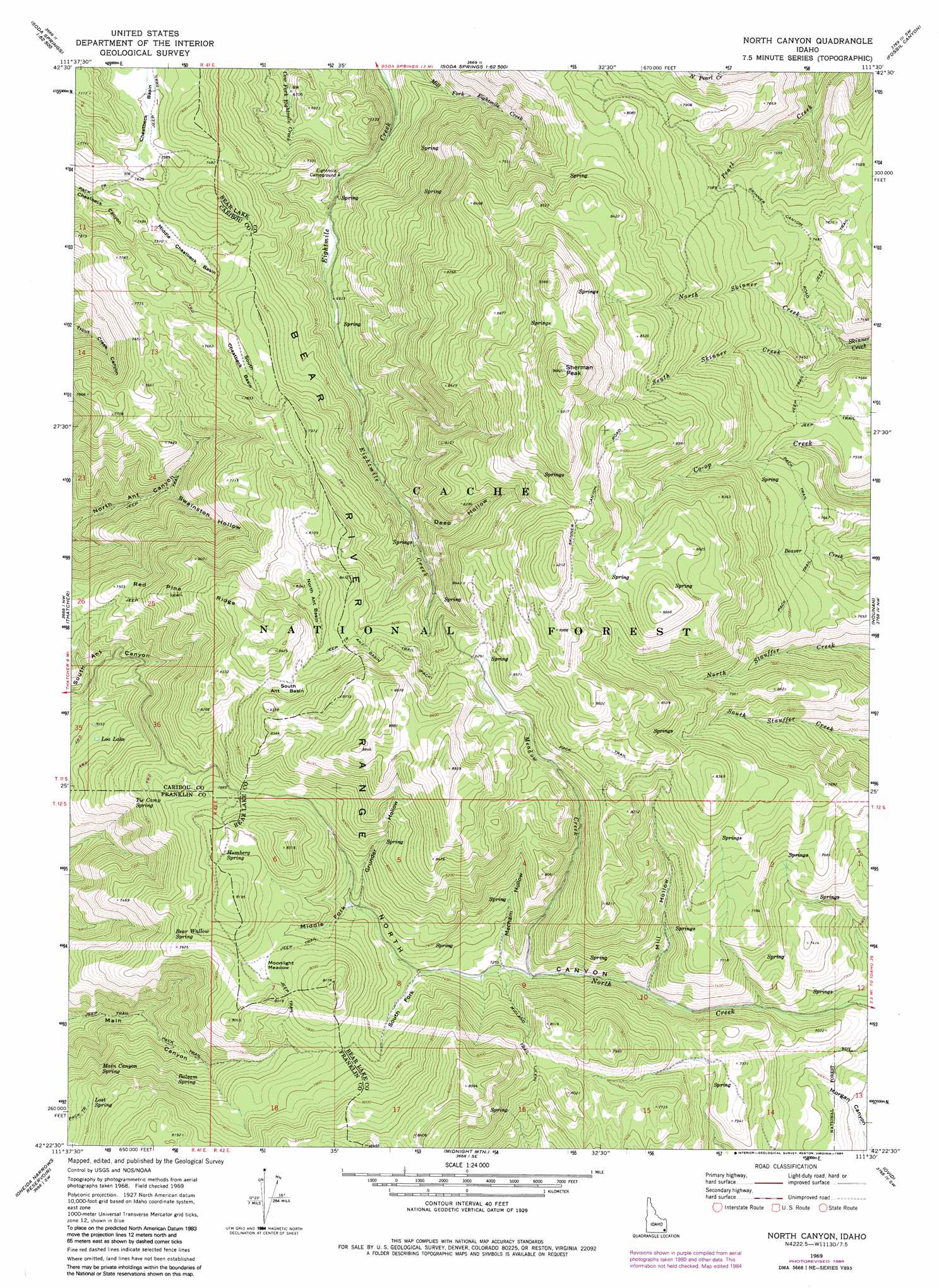
USGS Topo Quad 42111d5 - 1:24,000 scale
| Topo Map Name: | North Canyon |
| USGS Topo Quad ID: | 42111d5 |
| Print Size: | ca. 21 1/4" wide x 27" high |
| Southeast Coordinates: | 42.375° N latitude / 111.5° W longitude |
| Map Center Coordinates: | 42.4375° N latitude / 111.5625° W longitude |
| U.S. State: | ID |
| Filename: | o42111d5.jpg |
| Download Map JPG Image: | North Canyon topo map 1:24,000 scale |
| Map Type: | Topographic |
| Topo Series: | 7.5´ |
| Map Scale: | 1:24,000 |
| Source of Map Images: | United States Geological Survey (USGS) |
| Alternate Map Versions: |
North Canyon ID 1969, updated 1973 Download PDF Buy paper map North Canyon ID 1969, updated 1984 Download PDF Buy paper map North Canyon ID 2005, updated 2007 Download PDF Buy paper map North Canyon ID 2011 Download PDF Buy paper map North Canyon ID 2013 Download PDF Buy paper map |
| FStopo: | US Forest Service topo North Canyon is available: Download FStopo PDF Download FStopo TIF |
1:24,000 Topo Quads surrounding North Canyon
Talmage |
Alexander |
Soda Springs |
Johnson Creek |
Dry Valley |
Grace Power Plant |
Grace |
Soda Peak |
Fossil Canyon |
Harrington Peak |
Thatcher Hill |
Thatcher |
North Canyon |
Nounan |
Georgetown |
Treasureton |
Oneida Narrows Reservoir |
Midnight Mountain |
Ovid |
Montpelier |
Riverdale |
Mink Creek |
Paris Peak |
Paris |
Dingle |
> Back to 42111a1 at 1:100,000 scale
> Back to 42110a1 at 1:250,000 scale
> Back to U.S. Topo Maps home
North Canyon topo map: Gazetteer
North Canyon: Basins
Cheatbeck Basin elevation 2252m 7388′North Ant Basin elevation 2473m 8113′
South Ant Basin elevation 2526m 8287′
South Cheatbeck Basin elevation 2314m 7591′
North Canyon: Flats
Moonlight Meadow elevation 2399m 7870′North Canyon: Lakes
Loa Lake elevation 2167m 7109′North Canyon: Ridges
Red Pine Ridge elevation 2282m 7486′North Canyon: Springs
Balsam Spring elevation 2284m 7493′Bear Wallow Spring elevation 2384m 7821′
Humberg Spring elevation 2447m 8028′
Lost Spring elevation 2307m 7568′
Main Canyon Spring elevation 2250m 7381′
Tie Camp Spring elevation 2293m 7522′
North Canyon: Streams
Meadow Creek elevation 2199m 7214′North Pearl Creek elevation 2186m 7171′
North Skinner Creek elevation 2121m 6958′
South Skinner Creek elevation 2121m 6958′
North Canyon: Summits
Sherman Peak elevation 2954m 9691′North Canyon: Valleys
Deep Hollow elevation 2293m 7522′Grunder Hollow elevation 2314m 7591′
Mercham Hollow elevation 2217m 7273′
Middle Fork North Canyon elevation 2321m 7614′
Mill Hollow elevation 2153m 7063′
South Fork North Canyon elevation 2258m 7408′
Swainston Hollow elevation 2078m 6817′
North Canyon digital topo map on disk
Buy this North Canyon topo map showing relief, roads, GPS coordinates and other geographical features, as a high-resolution digital map file on DVD: