Cottonwood Peak Topo Map Idaho
To zoom in, hover over the map of Cottonwood Peak
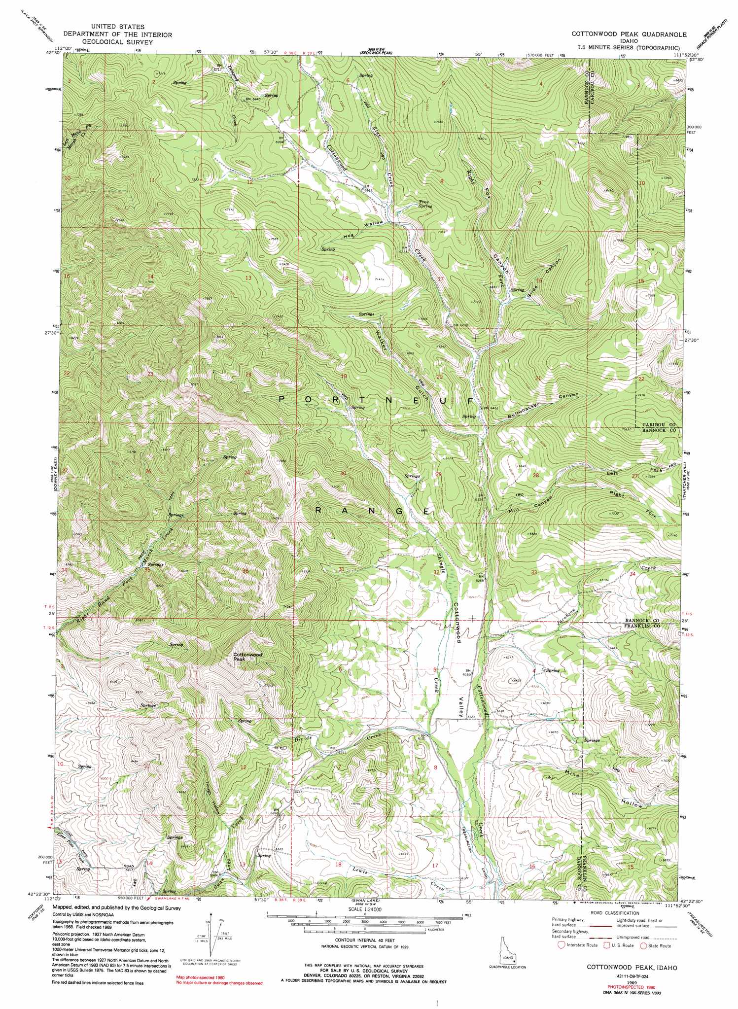
USGS Topo Quad 42111d8 - 1:24,000 scale
| Topo Map Name: | Cottonwood Peak |
| USGS Topo Quad ID: | 42111d8 |
| Print Size: | ca. 21 1/4" wide x 27" high |
| Southeast Coordinates: | 42.375° N latitude / 111.875° W longitude |
| Map Center Coordinates: | 42.4375° N latitude / 111.9375° W longitude |
| U.S. State: | ID |
| Filename: | o42111d8.jpg |
| Download Map JPG Image: | Cottonwood Peak topo map 1:24,000 scale |
| Map Type: | Topographic |
| Topo Series: | 7.5´ |
| Map Scale: | 1:24,000 |
| Source of Map Images: | United States Geological Survey (USGS) |
| Alternate Map Versions: |
Cottonwood Peak ID 1969, updated 1973 Download PDF Buy paper map Cottonwood Peak ID 1969, updated 1991 Download PDF Buy paper map Cottonwood Peak ID 2010 Download PDF Buy paper map Cottonwood Peak ID 2013 Download PDF Buy paper map |
1:24,000 Topo Quads surrounding Cottonwood Peak
Mccammon |
Haystack Mountain |
Bancroft |
Talmage |
Alexander |
Arimo |
Lava Hot Springs |
Sedgwick Peak |
Grace Power Plant |
Grace |
Downey West |
Downey East |
Cottonwood Peak |
Thatcher Hill |
Thatcher |
Malad Summit |
Oxford |
Swan Lake |
Treasureton |
Oneida Narrows Reservoir |
Malad City East |
Clifton |
Banida |
Riverdale |
Mink Creek |
> Back to 42111a1 at 1:100,000 scale
> Back to 42110a1 at 1:250,000 scale
> Back to U.S. Topo Maps home
Cottonwood Peak topo map: Gazetteer
Cottonwood Peak: Springs
Time Spring elevation 2115m 6938′Cottonwood Peak: Streams
Blue Creek elevation 2083m 6833′Divide Creek elevation 1860m 6102′
Jacobson Creek elevation 1880m 6167′
Lewis Creek elevation 1816m 5958′
Right Fork Cottonwood Creek elevation 1993m 6538′
Shingle Creek elevation 1826m 5990′
Cottonwood Peak: Summits
Cottonwood Peak elevation 2406m 7893′Cottonwood Peak: Valleys
Bullwhacker Canyon elevation 1973m 6473′Cottonwood Valley elevation 1827m 5994′
Fox Canyon elevation 2041m 6696′
Hog Wallow elevation 2083m 6833′
Left Fork Mill Canyon elevation 2003m 6571′
Mill Canyon elevation 1926m 6318′
Mine Hollow elevation 1849m 6066′
Right Fork Mill Canyon elevation 2003m 6571′
Slide Canyon elevation 2040m 6692′
Tough Hollow elevation 1853m 6079′
Trough Hollow elevation 1852m 6076′
Walker Gulch elevation 1962m 6437′
Cottonwood Peak digital topo map on disk
Buy this Cottonwood Peak topo map showing relief, roads, GPS coordinates and other geographical features, as a high-resolution digital map file on DVD: