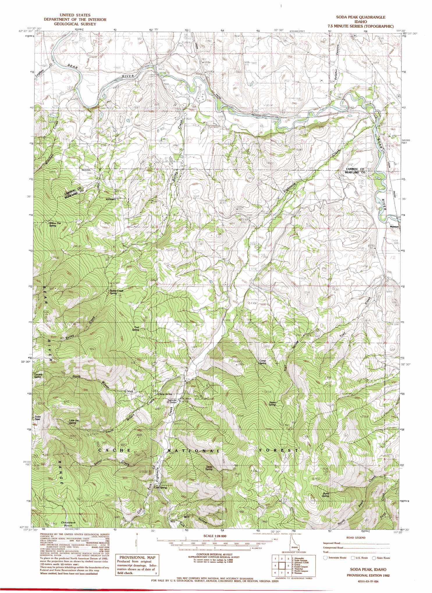
Soda Peak Topo Map Idaho
To zoom in, hover over the map of Soda Peak
USGS Topo Quad 42111e5 - 1:24,000 scale
| Topo Map Name: | Soda Peak |
| USGS Topo Quad ID: | 42111e5 |
| Print Size: | ca. 21 1/4" wide x 27" high |
| Southeast Coordinates: | 42.5° N latitude / 111.5° W longitude |
| Map Center Coordinates: | 42.5625° N latitude / 111.5625° W longitude |
| U.S. State: | ID |
| Filename: | o42111e5.jpg |
| Download Map JPG Image: | Soda Peak topo map 1:24,000 scale |
| Map Type: | Topographic |
| Topo Series: | 7.5´ |
| Map Scale: | 1:24,000 |
| Source of Map Images: | United States Geological Survey (USGS) |
| Alternate Map Versions: |
Soda Peak ID 1982, updated 1982 Download PDF Buy paper map Soda Peak ID 2005, updated 2007 Download PDF Buy paper map Soda Peak ID 2011 Download PDF Buy paper map Soda Peak ID 2013 Download PDF Buy paper map |
| FStopo: | US Forest Service topo Soda Peak is available: Download FStopo PDF Download FStopo TIF |
1:24,000 Topo Quads surrounding Soda Peak
Hatch |
The Dip |
China Hat |
Lower Valley |
Upper Valley |
Talmage |
Alexander |
Soda Springs |
Johnson Creek |
Dry Valley |
Grace Power Plant |
Grace |
Soda Peak |
Fossil Canyon |
Harrington Peak |
Thatcher Hill |
Thatcher |
North Canyon |
Nounan |
Georgetown |
Treasureton |
Oneida Narrows Reservoir |
Midnight Mountain |
Ovid |
Montpelier |
> Back to 42111e1 at 1:100,000 scale
> Back to 42110a1 at 1:250,000 scale
> Back to U.S. Topo Maps home
Soda Peak topo map: Gazetteer
Soda Peak: Populated Places
Rose elevation 1768m 5800′Soda Peak: Springs
Aspen Spring elevation 2184m 7165′Bailey Creek Spring elevation 2055m 6742′
Burnt Spring elevation 2291m 7516′
Camp Spring elevation 2001m 6564′
Little Joe Spring elevation 2361m 7746′
Steep Spring elevation 2152m 7060′
Trail Spring elevation 2119m 6952′
Trouble Spring elevation 2499m 8198′
Willow Flat Spring elevation 2108m 6916′
Soda Peak: Streams
Bailey Creek elevation 1760m 5774′Cow Fork Eightmile Creek elevation 1946m 6384′
Eightmile Creek elevation 1771m 5810′
Largilliere Creek elevation 1753m 5751′
Ledger Creek elevation 1759m 5770′
Mill Fork Eightmile Creek elevation 1981m 6499′
North Wilson Creek elevation 1894m 6213′
Sotter Creek elevation 1930m 6332′
South Wilson Creek elevation 1926m 6318′
Trail Creek elevation 1781m 5843′
Winchell Creek elevation 1753m 5751′
Soda Peak: Valleys
Mill Hollow elevation 1981m 6499′Sulphur Canyon elevation 1767m 5797′
Trail Hollow elevation 1850m 6069′
Soda Peak digital topo map on disk
Buy this Soda Peak topo map showing relief, roads, GPS coordinates and other geographical features, as a high-resolution digital map file on DVD: