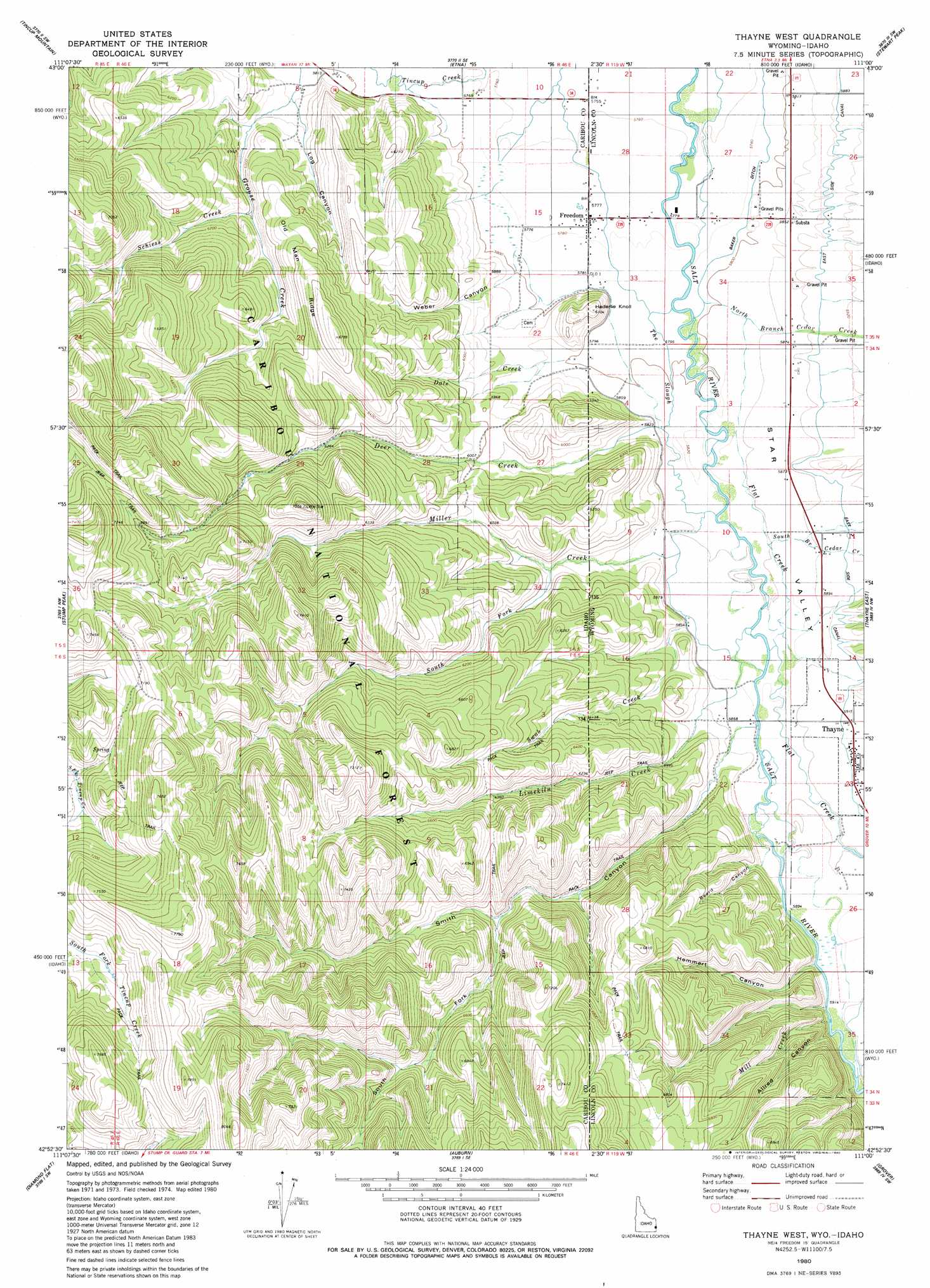
Thayne West Topo Map Idaho
To zoom in, hover over the map of Thayne West
USGS Topo Quad 42111h1 - 1:24,000 scale
| Topo Map Name: | Thayne West |
| USGS Topo Quad ID: | 42111h1 |
| Print Size: | ca. 21 1/4" wide x 27" high |
| Southeast Coordinates: | 42.875° N latitude / 111° W longitude |
| Map Center Coordinates: | 42.9375° N latitude / 111.0625° W longitude |
| U.S. States: | ID, WY |
| Filename: | o42111h1.jpg |
| Download Map JPG Image: | Thayne West topo map 1:24,000 scale |
| Map Type: | Topographic |
| Topo Series: | 7.5´ |
| Map Scale: | 1:24,000 |
| Source of Map Images: | United States Geological Survey (USGS) |
| Alternate Map Versions: |
Thayne West WY 1980, updated 1980 Download PDF Buy paper map Thayne West WY 1980, updated 1980 Download PDF Buy paper map Thayne West WY 1980, updated 1980 Download PDF Buy paper map Thayne West WY 2011 Download PDF Buy paper map Thayne West WY 2015 Download PDF Buy paper map |
| FStopo: | US Forest Service topo Thayne West is available: Download FStopo PDF Download FStopo TIF |
1:24,000 Topo Quads surrounding Thayne West
Big Elk Mountain |
Poker Peak |
Alpine |
Ferry Peak |
Pine Creek |
Caribou Mountain |
Tincup Mountain |
Etna |
Stewart Peak |
Deer Creek |
Wayan East |
Stump Peak |
Thayne West |
Thayne East |
Man Peak |
Upper Valley |
Diamond Flat |
Auburn |
Grover |
Rock Lake Peak |
Dry Valley |
Stewart Flat |
Sage Valley |
Afton |
Red Top Mountain |
> Back to 42111e1 at 1:100,000 scale
> Back to 42110a1 at 1:250,000 scale
> Back to U.S. Topo Maps home
Thayne West topo map: Gazetteer
Thayne West: Canals
East Side Canal elevation 1797m 5895′Thayne West: Guts
The Slough elevation 1767m 5797′Thayne West: Populated Places
Freedom elevation 1761m 5777′Thayne elevation 1800m 5905′
Thayne West: Ridges
Old Man Ridge elevation 2039m 6689′Thayne West: Streams
Dale Creek elevation 1775m 5823′Deer Creek elevation 1776m 5826′
Deer Creek elevation 1773m 5816′
Flat Creek elevation 1785m 5856′
Haderlie Creek elevation 1760m 5774′
Limekiln Creek elevation 1786m 5859′
Limekiln Creek elevation 1784m 5853′
Mill Creek elevation 1813m 5948′
Miller Creek elevation 1780m 5839′
Miller Creek elevation 1777m 5830′
North Branch Cedar Creek elevation 1768m 5800′
Schiess Creek elevation 1834m 6017′
South Fork Miller Creek elevation 1838m 6030′
Strawberry Creek elevation 1805m 5921′
Swab Creek elevation 1787m 5862′
Thayne West: Summits
Haderlie Knoll elevation 1858m 6095′Thayne West: Valleys
Allred Canyon elevation 1801m 5908′Beard Canyon elevation 1794m 5885′
Hemmert Canyon elevation 1797m 5895′
Log Canyon elevation 1793m 5882′
Smith Canyon elevation 1797m 5895′
Smith Canyon elevation 1787m 5862′
South Branch Cedar Creek elevation 1781m 5843′
South Fork Hemmert Canyon elevation 1804m 5918′
South Fork Smith Canyon elevation 1926m 6318′
Weber Canyon elevation 1787m 5862′
Thayne West digital topo map on disk
Buy this Thayne West topo map showing relief, roads, GPS coordinates and other geographical features, as a high-resolution digital map file on DVD: