Elkhorn Peak Topo Map Idaho
To zoom in, hover over the map of Elkhorn Peak
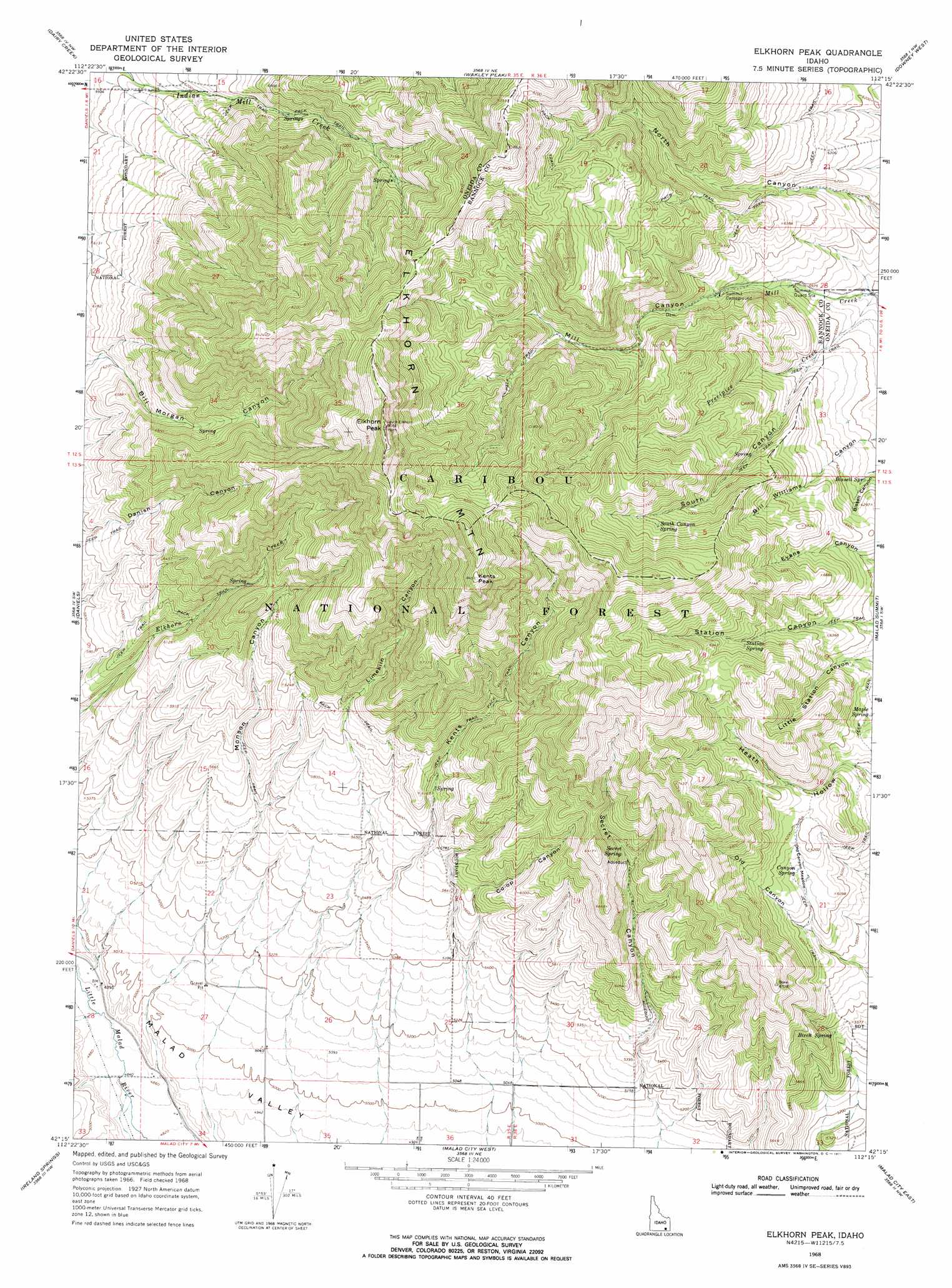
USGS Topo Quad 42112c3 - 1:24,000 scale
| Topo Map Name: | Elkhorn Peak |
| USGS Topo Quad ID: | 42112c3 |
| Print Size: | ca. 21 1/4" wide x 27" high |
| Southeast Coordinates: | 42.25° N latitude / 112.25° W longitude |
| Map Center Coordinates: | 42.3125° N latitude / 112.3125° W longitude |
| U.S. State: | ID |
| Filename: | o42112c3.jpg |
| Download Map JPG Image: | Elkhorn Peak topo map 1:24,000 scale |
| Map Type: | Topographic |
| Topo Series: | 7.5´ |
| Map Scale: | 1:24,000 |
| Source of Map Images: | United States Geological Survey (USGS) |
| Alternate Map Versions: |
Elkhorn Peak ID 1968, updated 1971 Download PDF Buy paper map Elkhorn Peak ID 2011 Download PDF Buy paper map Elkhorn Peak ID 2013 Download PDF Buy paper map |
| FStopo: | US Forest Service topo Elkhorn Peak is available: Download FStopo PDF Download FStopo TIF |
1:24,000 Topo Quads surrounding Elkhorn Peak
Pauline |
Bradley Mountain |
Hawkins |
Arimo |
Lava Hot Springs |
Arbon |
Dairy Creek |
Wakley Peak |
Downey West |
Downey East |
Buist |
Daniels |
Elkhorn Peak |
Malad Summit |
Oxford |
Sheep Creek Spring |
Ireland Springs |
Malad City West |
Malad City East |
Clifton |
Co-Op Spring |
Grover Canyon |
Samaria |
Henderson Creek |
Weston Canyon |
> Back to 42112a1 at 1:100,000 scale
> Back to 42112a1 at 1:250,000 scale
> Back to U.S. Topo Maps home
Elkhorn Peak topo map: Gazetteer
Elkhorn Peak: Flats
Old Canyon Meadow elevation 1867m 6125′Elkhorn Peak: Springs
Birch Spring elevation 1722m 5649′Bissell Spring elevation 1848m 6062′
Maple Spring elevation 1835m 6020′
Old Canyon Spring elevation 1867m 6125′
Secret Spring elevation 1984m 6509′
South Canyon Spring elevation 2179m 7148′
Station Spring elevation 2044m 6706′
Elkhorn Peak: Streams
Precipice Creek elevation 1769m 5803′Elkhorn Peak: Summits
Elkhorn Mountain elevation 2432m 7979′Elkhorn Peak elevation 2703m 8868′
Kents Peak elevation 2569m 8428′
Elkhorn Peak: Valleys
Bill Williams Canyon elevation 1824m 5984′Bissell Canyon elevation 1833m 6013′
Co-Op Canyon elevation 1661m 5449′
Kents Canyon elevation 1711m 5613′
Limekiln Canyon elevation 1940m 6364′
Mill Canyon elevation 1833m 6013′
Monson Canyon elevation 1699m 5574′
Old Canyon elevation 1774m 5820′
Secret Canyon elevation 1594m 5229′
South Canyon elevation 1772m 5813′
Elkhorn Peak digital topo map on disk
Buy this Elkhorn Peak topo map showing relief, roads, GPS coordinates and other geographical features, as a high-resolution digital map file on DVD: