Lava Hot Springs Topo Map Idaho
To zoom in, hover over the map of Lava Hot Springs
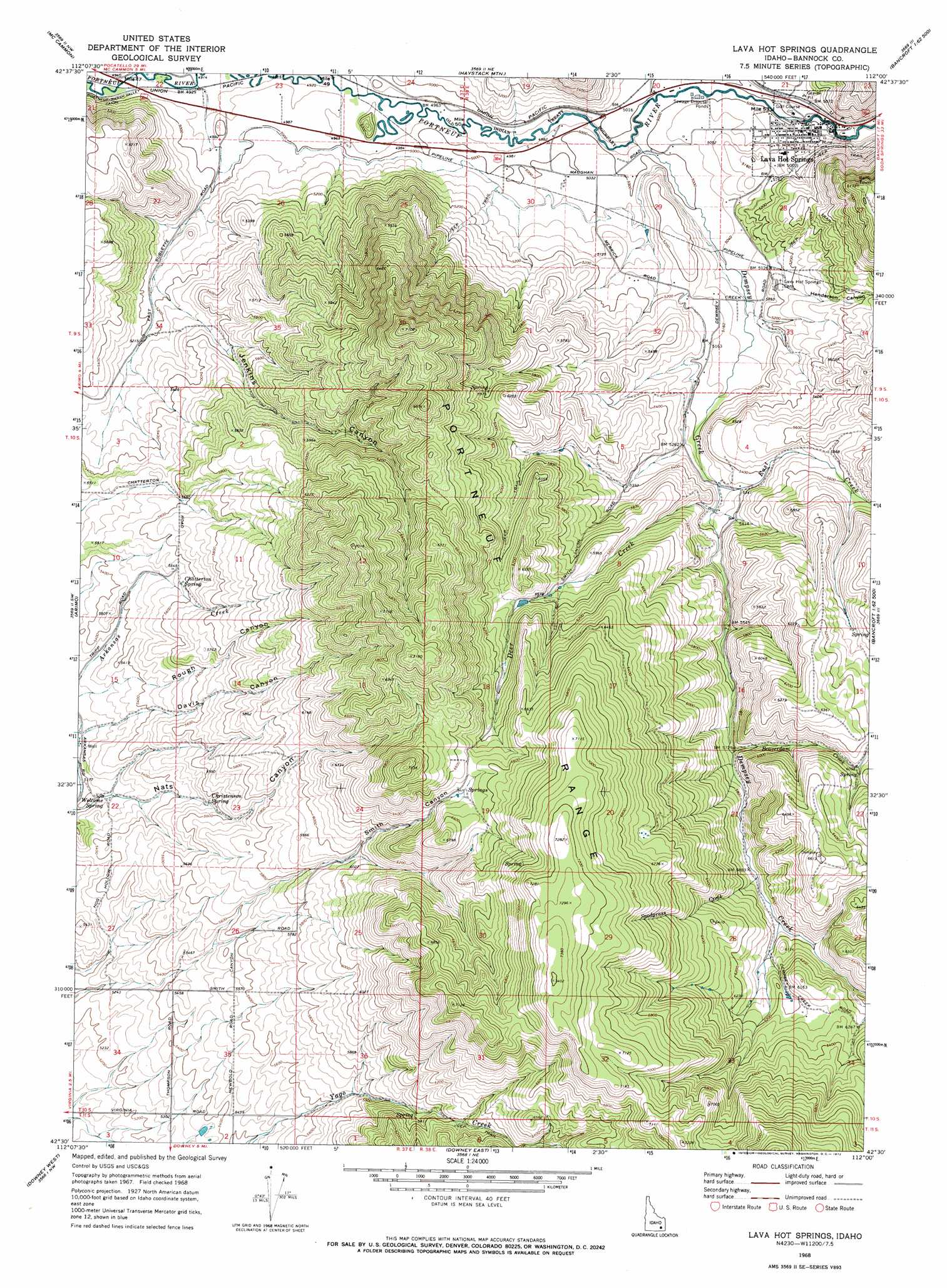
USGS Topo Quad 42112e1 - 1:24,000 scale
| Topo Map Name: | Lava Hot Springs |
| USGS Topo Quad ID: | 42112e1 |
| Print Size: | ca. 21 1/4" wide x 27" high |
| Southeast Coordinates: | 42.5° N latitude / 112° W longitude |
| Map Center Coordinates: | 42.5625° N latitude / 112.0625° W longitude |
| U.S. State: | ID |
| Filename: | o42112e1.jpg |
| Download Map JPG Image: | Lava Hot Springs topo map 1:24,000 scale |
| Map Type: | Topographic |
| Topo Series: | 7.5´ |
| Map Scale: | 1:24,000 |
| Source of Map Images: | United States Geological Survey (USGS) |
| Alternate Map Versions: |
Lava Hot Springs ID 1968, updated 1972 Download PDF Buy paper map Lava Hot Springs ID 1968, updated 1972 Download PDF Buy paper map Lava Hot Springs ID 2010 Download PDF Buy paper map Lava Hot Springs ID 2013 Download PDF Buy paper map |
1:24,000 Topo Quads surrounding Lava Hot Springs
Inkom |
Bonneville Peak |
Bear Camp Gulch |
Chesterfield |
Hatch |
Scout Mountain |
Mccammon |
Haystack Mountain |
Bancroft |
Talmage |
Hawkins |
Arimo |
Lava Hot Springs |
Sedgwick Peak |
Grace Power Plant |
Wakley Peak |
Downey West |
Downey East |
Cottonwood Peak |
Thatcher Hill |
Elkhorn Peak |
Malad Summit |
Oxford |
Swan Lake |
Treasureton |
> Back to 42112e1 at 1:100,000 scale
> Back to 42112a1 at 1:250,000 scale
> Back to U.S. Topo Maps home
Lava Hot Springs topo map: Gazetteer
Lava Hot Springs: Populated Places
Lava Hot Springs elevation 1530m 5019′Lava Hot Springs: Springs
Chatterton Spring elevation 1697m 5567′Christenson Spring elevation 1685m 5528′
Welcome Spring elevation 1587m 5206′
Lava Hot Springs: Streams
Beaverdam Creek elevation 1749m 5738′Deer Creek elevation 1623m 5324′
Dempsey Creek elevation 1513m 4963′
East Creek elevation 1612m 5288′
Lava Hot Springs: Valleys
Davis Canyon elevation 1598m 5242′Henderson Canyon elevation 1571m 5154′
Jenkins Canyon elevation 1502m 4927′
Smith Canyon elevation 1821m 5974′
Lava Hot Springs digital topo map on disk
Buy this Lava Hot Springs topo map showing relief, roads, GPS coordinates and other geographical features, as a high-resolution digital map file on DVD: