Mahogany Butte Topo Map Idaho
To zoom in, hover over the map of Mahogany Butte
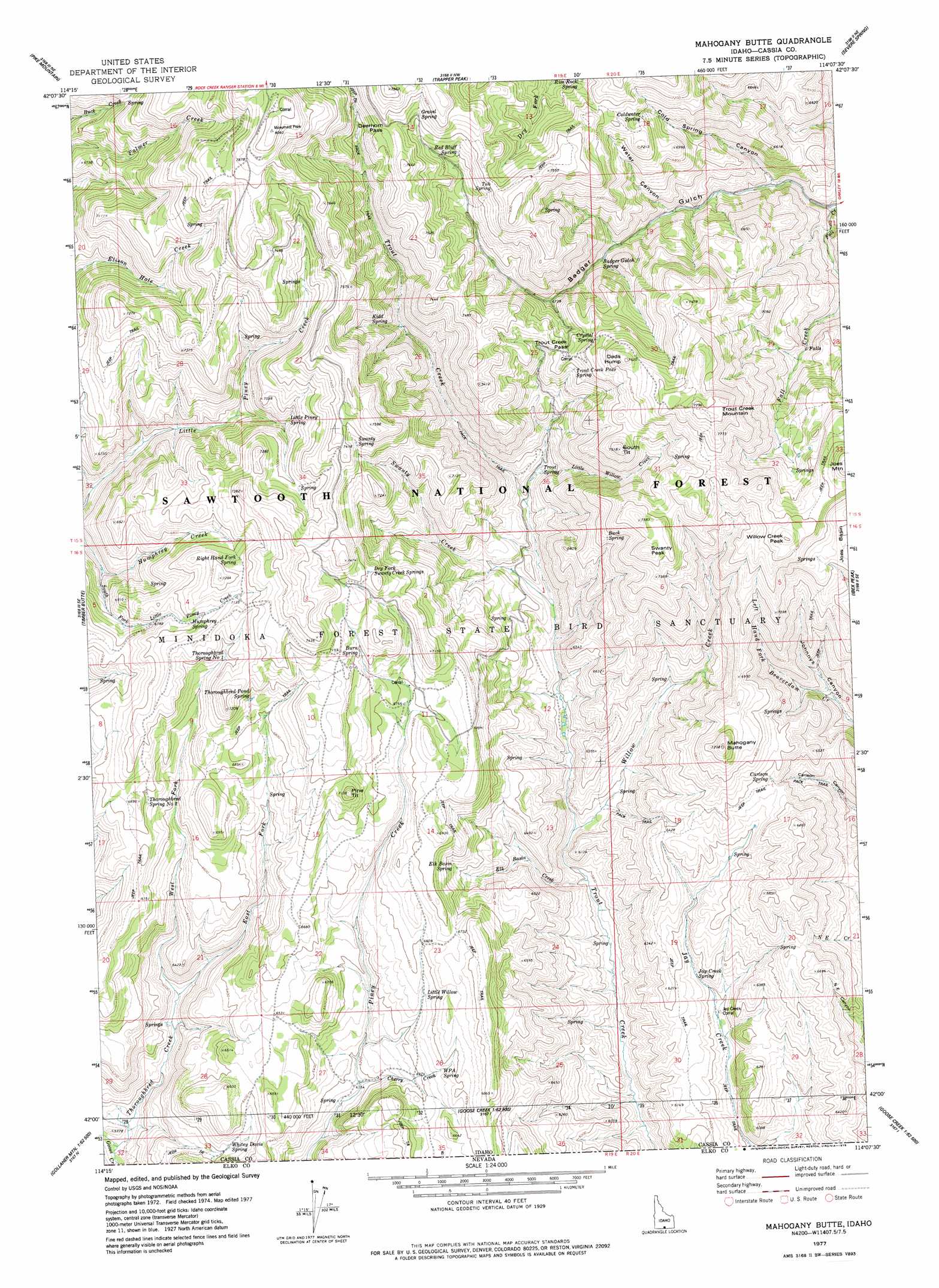
USGS Topo Quad 42114a2 - 1:24,000 scale
| Topo Map Name: | Mahogany Butte |
| USGS Topo Quad ID: | 42114a2 |
| Print Size: | ca. 21 1/4" wide x 27" high |
| Southeast Coordinates: | 42° N latitude / 114.125° W longitude |
| Map Center Coordinates: | 42.0625° N latitude / 114.1875° W longitude |
| U.S. State: | ID |
| Filename: | o42114a2.jpg |
| Download Map JPG Image: | Mahogany Butte topo map 1:24,000 scale |
| Map Type: | Topographic |
| Topo Series: | 7.5´ |
| Map Scale: | 1:24,000 |
| Source of Map Images: | United States Geological Survey (USGS) |
| Alternate Map Versions: |
Mahogany Butte ID 1977, updated 1978 Download PDF Buy paper map Mahogany Butte ID 2001, updated 2006 Download PDF Buy paper map Mahogany Butte ID 2011 Download PDF Buy paper map Mahogany Butte ID 2013 Download PDF Buy paper map |
| FStopo: | US Forest Service topo Mahogany Butte is available: Download FStopo PDF Download FStopo TIF |
1:24,000 Topo Quads surrounding Mahogany Butte
Mcmullen Basin |
Grand View Peak |
Rams Horn Ridge |
Buckhorn Canyon |
Marion |
Hopper Gulch |
Pike Mountain |
Trapper Peak |
Severe Spring |
Oakley |
Big Creek Ranch |
Timber Butte |
Mahogany Butte |
Ibex Peak |
Blue Hill |
Gollaher Mountain |
Stratton Spring |
Fivemile Gulch |
Nile Spring |
Pole Creek |
Devils Pass |
Mustang Draw |
Cedar Mountain Draw |
Judd Mountain |
Dry Canyon Mountain |
> Back to 42114a1 at 1:100,000 scale
> Back to 42114a1 at 1:250,000 scale
> Back to U.S. Topo Maps home
Mahogany Butte topo map: Gazetteer
Mahogany Butte: Basins
Joes Basin elevation 2145m 7037′Mahogany Butte: Falls
Phantom Falls elevation 1956m 6417′Mahogany Butte: Gaps
Deerhorn Pass elevation 2295m 7529′Trout Creek Pass elevation 2135m 7004′
Mahogany Butte: Springs
Badger Gulch Spring elevation 2006m 6581′Buck Spring elevation 2176m 7139′
Burn Spring elevation 2141m 7024′
Carlson Spring elevation 1999m 6558′
Coldwater Spring elevation 2130m 6988′
Crystal Spring elevation 2197m 7208′
Dry Fork Swanty Creek Spring elevation 2194m 7198′
Elk Basin Spring elevation 1973m 6473′
Gravel Spring elevation 2267m 7437′
Humphrey Spring elevation 2124m 6968′
Jay Creek Spring elevation 1841m 6040′
Kidd Spring elevation 2121m 6958′
Little Piney Spring elevation 2089m 6853′
Little Willow Spring elevation 1987m 6519′
Picketts Lower Trough Spring elevation 2084m 6837′
Red Bluff Spring elevation 2216m 7270′
Right Hand Fork Spring elevation 2158m 7080′
Rim Rock Spring elevation 2169m 7116′
Swanty Spring elevation 2241m 7352′
Thoroughbred Pond Spring elevation 2110m 6922′
Thoroughbred Spring Number One elevation 2118m 6948′
Thoroughbred Spring Number Two elevation 2069m 6788′
Trout Creek Pass Spring elevation 2123m 6965′
Trout Spring elevation 1912m 6272′
Tub Spring elevation 2246m 7368′
W P A Spring elevation 1985m 6512′
Mahogany Butte: Streams
Badger Creek elevation 1759m 5770′Cherry Creek elevation 1868m 6128′
East Fork Thoroughbred Creek elevation 1804m 5918′
Elk Basin Creek elevation 1765m 5790′
Humphrey Creek elevation 1935m 6348′
Little Willow Creek elevation 1882m 6174′
Swanty Creek elevation 1851m 6072′
West Fork Thoroughbred Creek elevation 1804m 5918′
Willow Creek elevation 1793m 5882′
Mahogany Butte: Summits
Dads Hump elevation 2310m 7578′Joes Mountain elevation 2344m 7690′
Mahogany Butte elevation 2198m 7211′
Pine Tit elevation 2163m 7096′
South Tit elevation 2284m 7493′
Swanty Peak elevation 2310m 7578′
Trout Creek Mountain elevation 2391m 7844′
Willow Creek Peak elevation 2319m 7608′
Mahogany Butte: Valleys
Badger Gulch elevation 1759m 5770′Cold Spring Canyon elevation 1829m 6000′
Water Canyon elevation 1912m 6272′
Mahogany Butte digital topo map on disk
Buy this Mahogany Butte topo map showing relief, roads, GPS coordinates and other geographical features, as a high-resolution digital map file on DVD: