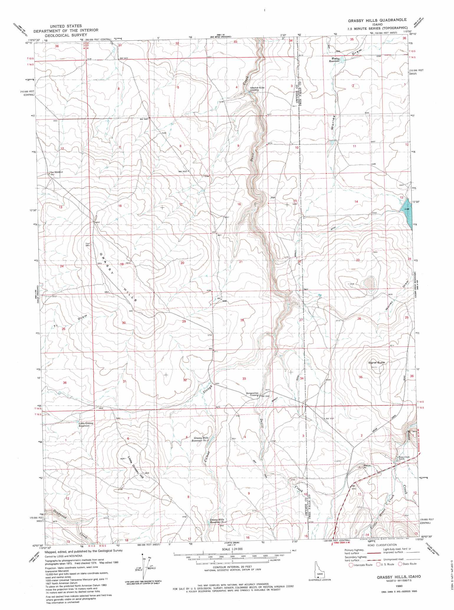
Grassy Hills Topo Map Idaho
To zoom in, hover over the map of Grassy Hills
USGS Topo Quad 42115b1 - 1:24,000 scale
| Topo Map Name: | Grassy Hills |
| USGS Topo Quad ID: | 42115b1 |
| Print Size: | ca. 21 1/4" wide x 27" high |
| Southeast Coordinates: | 42.125° N latitude / 115° W longitude |
| Map Center Coordinates: | 42.1875° N latitude / 115.0625° W longitude |
| U.S. State: | ID |
| Filename: | o42115b1.jpg |
| Download Map JPG Image: | Grassy Hills topo map 1:24,000 scale |
| Map Type: | Topographic |
| Topo Series: | 7.5´ |
| Map Scale: | 1:24,000 |
| Source of Map Images: | United States Geological Survey (USGS) |
| Alternate Map Versions: |
Grassy Hills ID 1980, updated 1980 Download PDF Buy paper map Grassy Hills ID 1980, updated 1980 Download PDF Buy paper map Grassy Hills ID 2011 Download PDF Buy paper map Grassy Hills ID 2013 Download PDF Buy paper map |
1:24,000 Topo Quads surrounding Grassy Hills
Juniper Ranch |
Horse Butte |
Coonskin Butte Ne |
Tuanna Butte |
Roseworth Ne |
Juniper Butte |
Coonskin Butte |
Big Bend Crossing |
Roseworth |
Roseworth Se |
Mosquito Lake Butte |
Salls Crossing |
Grassy Hills |
Cedar Creek Reservoir |
Browns Bench North |
Murphy Hot Springs |
Three Creek |
Curtis Draw |
Taylor Canyon |
Browns Bench South |
Robinson Creek |
Caudle Creek |
Elk Mountain |
Bear Mountain |
Browns Bench Ranch |
> Back to 42115a1 at 1:100,000 scale
> Back to 42114a1 at 1:250,000 scale
> Back to U.S. Topo Maps home
Grassy Hills topo map: Gazetteer
Grassy Hills: Canals
Worley Ditch elevation 1726m 5662′Grassy Hills: Crossings
Bengeochea Crossing elevation 1721m 5646′Marshall Butte Crossing elevation 1607m 5272′
Grassy Hills: Dams
Heil Dam elevation 1679m 5508′Grassy Hills: Ranges
Grassy Hills elevation 1784m 5853′Grassy Hills: Reservoirs
Grassy Hills Reservoir Number Three elevation 1755m 5757′Grassy Hills Reservoir Number Two elevation 1731m 5679′
Little Grassy Reservoir elevation 1716m 5629′
Worley Reservoir elevation 1642m 5387′
Grassy Hills: Streams
Camas Slough elevation 1701m 5580′Little House Creek elevation 1733m 5685′
Grassy Hills: Summits
Little Grassy Hill elevation 1785m 5856′Signal Butte elevation 1800m 5905′
Grassy Hills digital topo map on disk
Buy this Grassy Hills topo map showing relief, roads, GPS coordinates and other geographical features, as a high-resolution digital map file on DVD: