Mosquito Lake Butte Topo Map Idaho
To zoom in, hover over the map of Mosquito Lake Butte
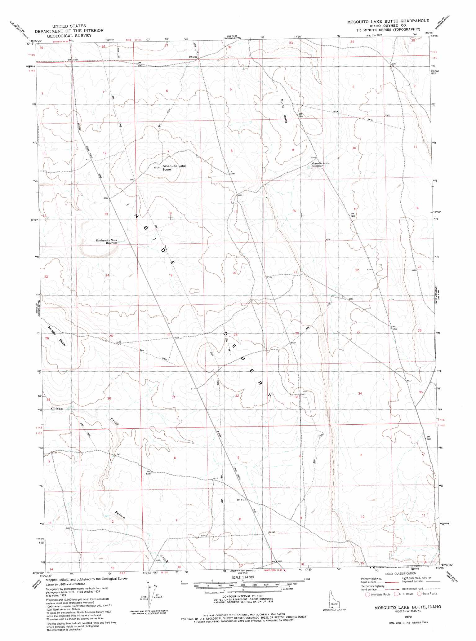
USGS Topo Quad 42115b3 - 1:24,000 scale
| Topo Map Name: | Mosquito Lake Butte |
| USGS Topo Quad ID: | 42115b3 |
| Print Size: | ca. 21 1/4" wide x 27" high |
| Southeast Coordinates: | 42.125° N latitude / 115.25° W longitude |
| Map Center Coordinates: | 42.1875° N latitude / 115.3125° W longitude |
| U.S. State: | ID |
| Filename: | o42115b3.jpg |
| Download Map JPG Image: | Mosquito Lake Butte topo map 1:24,000 scale |
| Map Type: | Topographic |
| Topo Series: | 7.5´ |
| Map Scale: | 1:24,000 |
| Source of Map Images: | United States Geological Survey (USGS) |
| Alternate Map Versions: |
Mosquito Lake Butte ID 1979, updated 1980 Download PDF Buy paper map Mosquito Lake Butte ID 2010 Download PDF Buy paper map Mosquito Lake Butte ID 2013 Download PDF Buy paper map |
1:24,000 Topo Quads surrounding Mosquito Lake Butte
Stiff Tree Draw |
Clover Butte North |
Juniper Ranch |
Horse Butte |
Coonskin Butte Ne |
Inside Lakes |
Clover Butte South |
Juniper Butte |
Coonskin Butte |
Big Bend Crossing |
The Arch |
Poison Butte |
Mosquito Lake Butte |
Salls Crossing |
Grassy Hills |
Cowan Reservoir |
Dishpan |
Murphy Hot Springs |
Three Creek |
Curtis Draw |
Bearpaw Mountain |
Jarbidge North |
Robinson Creek |
Caudle Creek |
Elk Mountain |
> Back to 42115a1 at 1:100,000 scale
> Back to 42114a1 at 1:250,000 scale
> Back to U.S. Topo Maps home
Mosquito Lake Butte topo map: Gazetteer
Mosquito Lake Butte: Airports
Bear Lake County Airport elevation 1623m 5324′Mosquito Lake Butte: Lakes
Mosquito Lake Reservoir elevation 1598m 5242′Rattlesnake Draw Reservoir elevation 1627m 5337′
Mosquito Lake Butte: Summits
Burnt Butte elevation 1631m 5351′Middle Butte elevation 1703m 5587′
Mosquito Lake Butte elevation 1697m 5567′
Mosquito Lake Butte digital topo map on disk
Buy this Mosquito Lake Butte topo map showing relief, roads, GPS coordinates and other geographical features, as a high-resolution digital map file on DVD: