Stoney Corral Topo Map Oregon
To zoom in, hover over the map of Stoney Corral
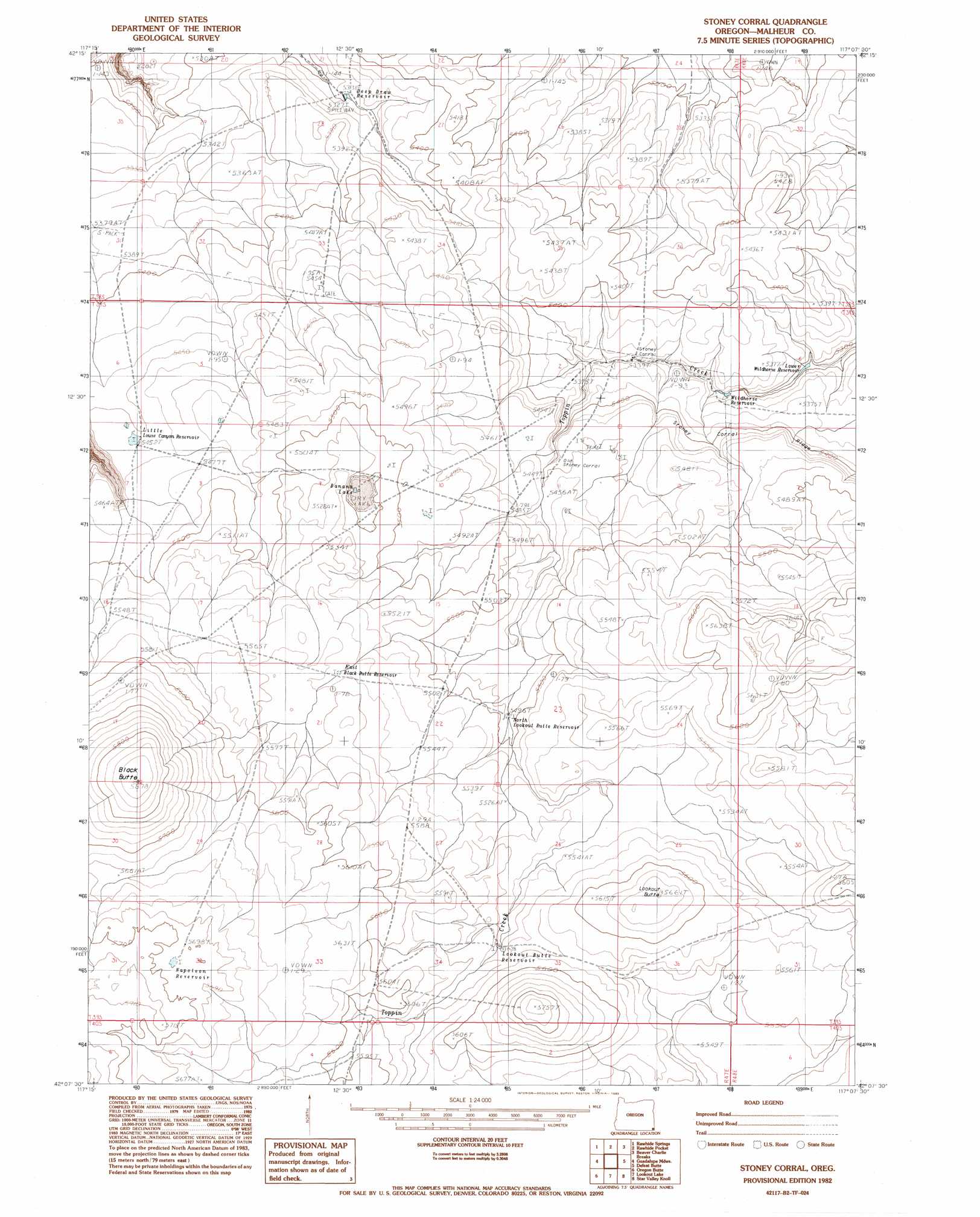
USGS Topo Quad 42117b2 - 1:24,000 scale
| Topo Map Name: | Stoney Corral |
| USGS Topo Quad ID: | 42117b2 |
| Print Size: | ca. 21 1/4" wide x 27" high |
| Southeast Coordinates: | 42.125° N latitude / 117.125° W longitude |
| Map Center Coordinates: | 42.1875° N latitude / 117.1875° W longitude |
| U.S. State: | OR |
| Filename: | o42117b2.jpg |
| Download Map JPG Image: | Stoney Corral topo map 1:24,000 scale |
| Map Type: | Topographic |
| Topo Series: | 7.5´ |
| Map Scale: | 1:24,000 |
| Source of Map Images: | United States Geological Survey (USGS) |
| Alternate Map Versions: |
Stoney Corral OR 1982, updated 1983 Download PDF Buy paper map Stoney Corral OR 2011 Download PDF Buy paper map Stoney Corral OR 2014 Download PDF Buy paper map |
1:24,000 Topo Quads surrounding Stoney Corral
Peacock Lake |
No Crossing Crossing |
Drummond Basin |
Deacon Crossing |
Bedstead Ridge |
Starvation Spring |
Rawhide Springs |
Rawhide Pocket |
Beaver Charlie Breaks |
Bull Basin Camp |
Chipmunk Basin |
Guadalupe Meadows |
Stoney Corral |
Defeat Butte |
Spring Creek Basin |
Deer Flat |
Oregon Butte |
Lookout Lake |
Star Valley Knoll |
Star Valley |
Odell Mountain |
Mahogany Spring |
Calico Butte |
Nadine Butte |
Star Valley Ridge West |
> Back to 42117a1 at 1:100,000 scale
> Back to 42116a1 at 1:250,000 scale
> Back to U.S. Topo Maps home
Stoney Corral topo map: Gazetteer
Stoney Corral: Reservoirs
Banana Lake elevation 1670m 5479′Deep Draw Reservoir elevation 1624m 5328′
East Black Butte Reservoir elevation 1694m 5557′
Little Louse Canyon Reservoir elevation 1663m 5456′
Lookout Butte Reservoir elevation 1693m 5554′
Lower Wildhorse Reservoir elevation 1616m 5301′
Napoleon Reservoir elevation 1738m 5702′
North Lookout Butte Reservoir elevation 1677m 5501′
Wildhorse Reservoir elevation 1622m 5321′
Stoney Corral: Ridges
Stoney Corral Ridge elevation 1648m 5406′Stoney Corral: Summits
Black Butte elevation 1778m 5833′Lookout Butte elevation 1724m 5656′
Stoney Corral digital topo map on disk
Buy this Stoney Corral topo map showing relief, roads, GPS coordinates and other geographical features, as a high-resolution digital map file on DVD: