Rawhide Pocket Topo Map Oregon
To zoom in, hover over the map of Rawhide Pocket
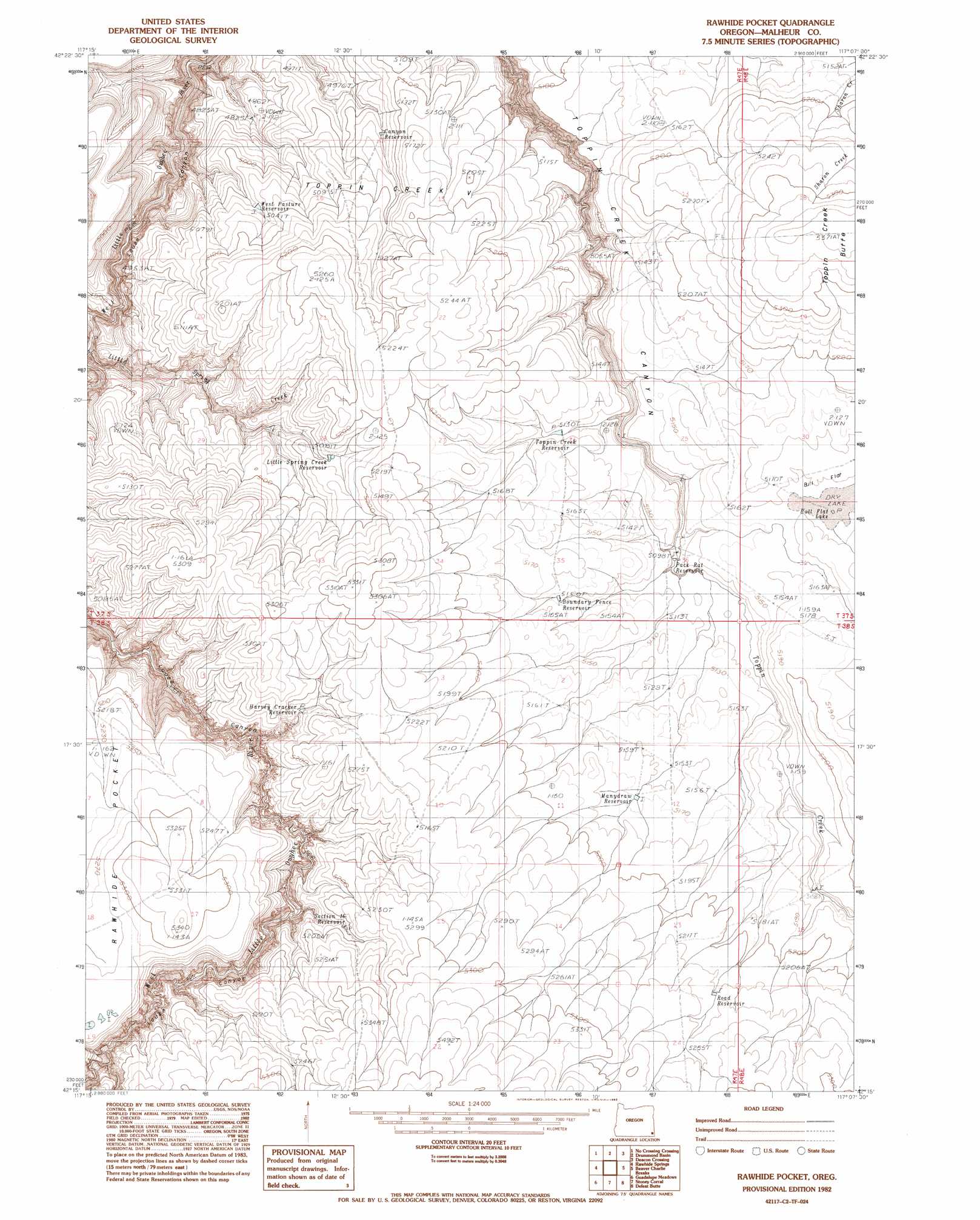
USGS Topo Quad 42117c2 - 1:24,000 scale
| Topo Map Name: | Rawhide Pocket |
| USGS Topo Quad ID: | 42117c2 |
| Print Size: | ca. 21 1/4" wide x 27" high |
| Southeast Coordinates: | 42.25° N latitude / 117.125° W longitude |
| Map Center Coordinates: | 42.3125° N latitude / 117.1875° W longitude |
| U.S. State: | OR |
| Filename: | o42117c2.jpg |
| Download Map JPG Image: | Rawhide Pocket topo map 1:24,000 scale |
| Map Type: | Topographic |
| Topo Series: | 7.5´ |
| Map Scale: | 1:24,000 |
| Source of Map Images: | United States Geological Survey (USGS) |
| Alternate Map Versions: |
Rawhide Pocket OR 1982, updated 1983 Download PDF Buy paper map Rawhide Pocket OR 2011 Download PDF Buy paper map Rawhide Pocket OR 2014 Download PDF Buy paper map |
1:24,000 Topo Quads surrounding Rawhide Pocket
Caviatta Ridge |
Squaw Flat |
Three Forks |
Brewster Reservoir |
Fairylawn |
Peacock Lake |
No Crossing Crossing |
Drummond Basin |
Deacon Crossing |
Bedstead Ridge |
Starvation Spring |
Rawhide Springs |
Rawhide Pocket |
Beaver Charlie Breaks |
Bull Basin Camp |
Chipmunk Basin |
Guadalupe Meadows |
Stoney Corral |
Defeat Butte |
Spring Creek Basin |
Deer Flat |
Oregon Butte |
Lookout Lake |
Star Valley Knoll |
Star Valley |
> Back to 42117a1 at 1:100,000 scale
> Back to 42116a1 at 1:250,000 scale
> Back to U.S. Topo Maps home
Rawhide Pocket topo map: Gazetteer
Rawhide Pocket: Lakes
Bull Flat Lake elevation 1572m 5157′Rawhide Pocket: Reservoirs
Boundary Fence Reservoir elevation 1569m 5147′Canyon Reservoir elevation 1534m 5032′
Harvey Cracker Reservoir elevation 1570m 5150′
Little Spring Creek Reservoir elevation 1564m 5131′
Manydraw Reservoir elevation 1577m 5173′
Pack Rat Reservoir elevation 1555m 5101′
Road Reservoir elevation 1594m 5229′
Section Sixteen Reservoir elevation 1581m 5187′
Toppin Creek Reservoir elevation 1566m 5137′
West Pasture Reservoir elevation 1531m 5022′
Rawhide Pocket: Summits
Toppin Creek Butte elevation 1633m 5357′Rawhide Pocket digital topo map on disk
Buy this Rawhide Pocket topo map showing relief, roads, GPS coordinates and other geographical features, as a high-resolution digital map file on DVD: