Rockhouse Reservoir Topo Map Oregon
To zoom in, hover over the map of Rockhouse Reservoir
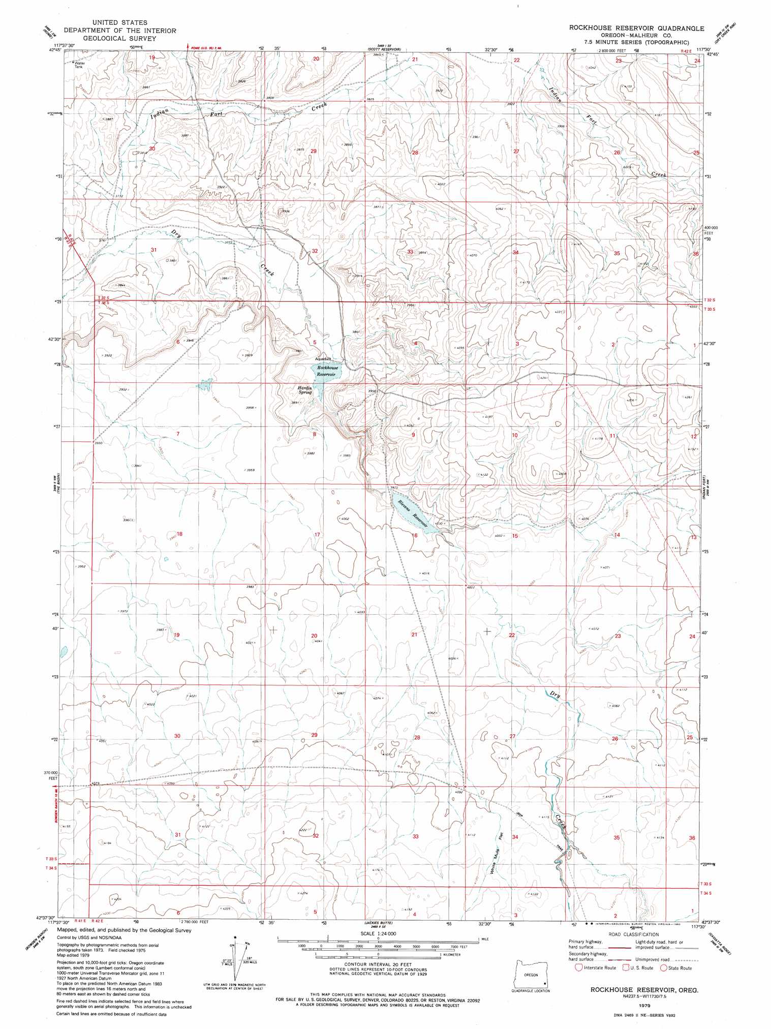
USGS Topo Quad 42117f5 - 1:24,000 scale
| Topo Map Name: | Rockhouse Reservoir |
| USGS Topo Quad ID: | 42117f5 |
| Print Size: | ca. 21 1/4" wide x 27" high |
| Southeast Coordinates: | 42.625° N latitude / 117.5° W longitude |
| Map Center Coordinates: | 42.6875° N latitude / 117.5625° W longitude |
| U.S. State: | OR |
| Filename: | o42117f5.jpg |
| Download Map JPG Image: | Rockhouse Reservoir topo map 1:24,000 scale |
| Map Type: | Topographic |
| Topo Series: | 7.5´ |
| Map Scale: | 1:24,000 |
| Source of Map Images: | United States Geological Survey (USGS) |
| Alternate Map Versions: |
Rockhouse Reservoir OR 1979, updated 1980 Download PDF Buy paper map Rockhouse Reservoir OR 2011 Download PDF Buy paper map Rockhouse Reservoir OR 2014 Download PDF Buy paper map |
1:24,000 Topo Quads surrounding Rockhouse Reservoir
Iron Mountain |
Owyhee Butte |
Arock |
Threemile Hill |
Danner |
Burns Junction |
Rome |
Scott Reservoir |
Dry Creek Rim |
Little Grassy Mountain |
Anderson Reservoir |
The Basin |
Rockhouse Reservoir |
Indian Fort |
Skull Creek |
Flat Top Mountain Se |
Bowden Ranch |
Jackies Butte |
Caviatta Ridge |
Squaw Flat |
Basque |
Battle Creek Ranch |
Rattlesnake Canyon |
Peacock Lake |
No Crossing Crossing |
> Back to 42117e1 at 1:100,000 scale
> Back to 42116a1 at 1:250,000 scale
> Back to U.S. Topo Maps home
Rockhouse Reservoir topo map: Gazetteer
Rockhouse Reservoir: Dams
Blevins Dam elevation 1215m 3986′Rock House Dam elevation 1163m 3815′
Rockhouse Reservoir: Flats
White Mule Flat elevation 1254m 4114′Rockhouse Reservoir: Reservoirs
Blevins Reservoir elevation 1215m 3986′Rock House Reservoir elevation 1163m 3815′
Rockhouse Reservoir elevation 1156m 3792′
Rockhouse Reservoir: Springs
Hardin Spring elevation 1164m 3818′Rockhouse Reservoir: Streams
Corbin Creek elevation 1212m 3976′Indian Fort Creek elevation 1153m 3782′
Rockhouse Reservoir digital topo map on disk
Buy this Rockhouse Reservoir topo map showing relief, roads, GPS coordinates and other geographical features, as a high-resolution digital map file on DVD: