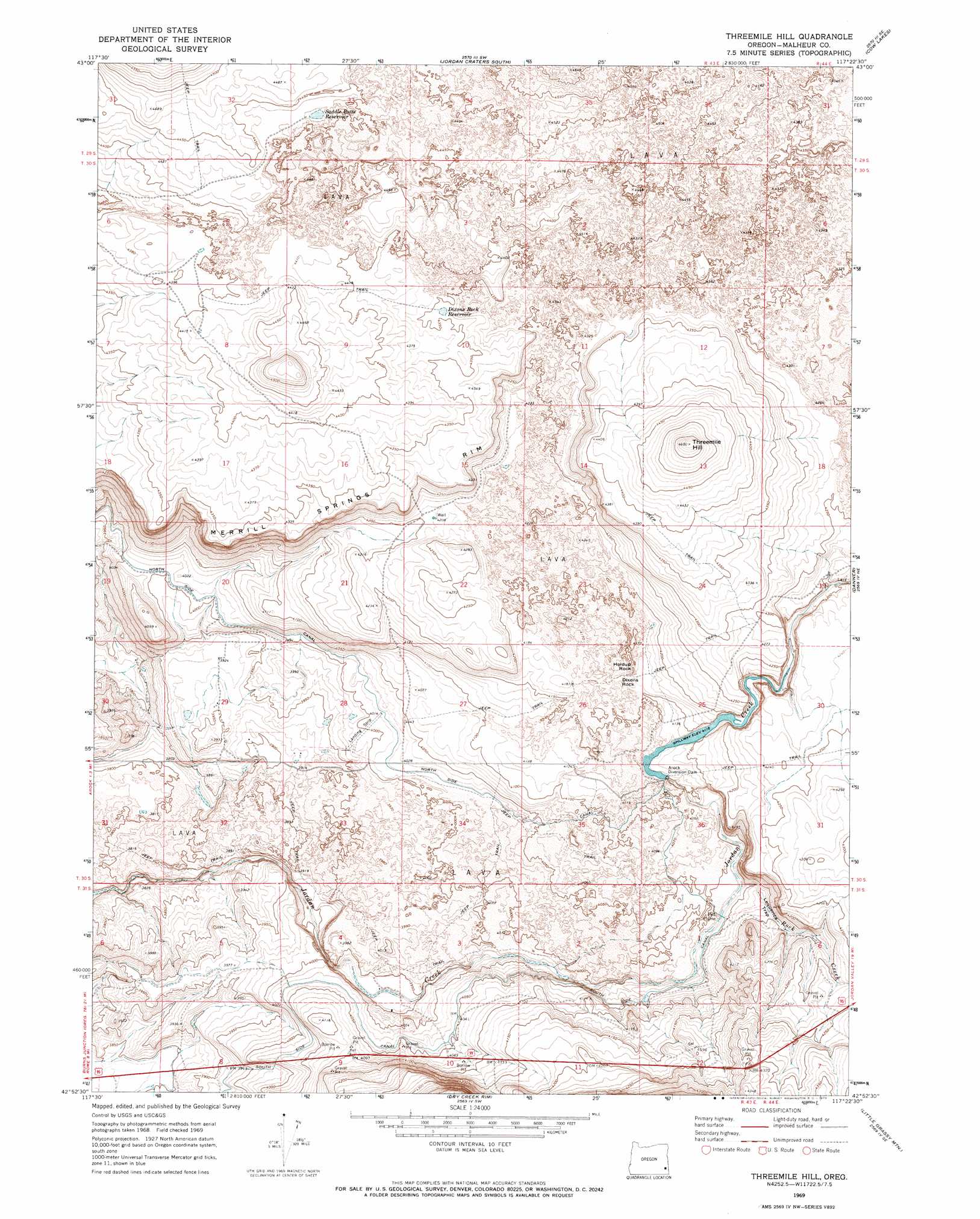
Threemile Hill Topo Map Oregon
To zoom in, hover over the map of Threemile Hill
USGS Topo Quad 42117h4 - 1:24,000 scale
| Topo Map Name: | Threemile Hill |
| USGS Topo Quad ID: | 42117h4 |
| Print Size: | ca. 21 1/4" wide x 27" high |
| Southeast Coordinates: | 42.875° N latitude / 117.375° W longitude |
| Map Center Coordinates: | 42.9375° N latitude / 117.4375° W longitude |
| U.S. State: | OR |
| Filename: | o42117h4.jpg |
| Download Map JPG Image: | Threemile Hill topo map 1:24,000 scale |
| Map Type: | Topographic |
| Topo Series: | 7.5´ |
| Map Scale: | 1:24,000 |
| Source of Map Images: | United States Geological Survey (USGS) |
| Alternate Map Versions: |
Threemile Hill OR 1969, updated 1973 Download PDF Buy paper map Threemile Hill OR 2011 Download PDF Buy paper map Threemile Hill OR 2014 Download PDF Buy paper map |
1:24,000 Topo Quads surrounding Threemile Hill
Rinehart Canyon |
The Hole In The Ground |
Jordan Craters North |
Mccain Creek |
Mahogany Gap |
Lambert Rocks |
Bogus Bench |
Jordan Craters South |
Cow Lakes |
Downey Canyon |
Owyhee Butte |
Arock |
Threemile Hill |
Danner |
Antelope Reservoir |
Rome |
Scott Reservoir |
Dry Creek Rim |
Little Grassy Mountain |
Juniper Ridge |
The Basin |
Rockhouse Reservoir |
Indian Fort |
Skull Creek |
Whitehorse Butte |
> Back to 42117e1 at 1:100,000 scale
> Back to 42116a1 at 1:250,000 scale
> Back to U.S. Topo Maps home
Threemile Hill topo map: Gazetteer
Threemile Hill: Basins
Lequerica Trap elevation 1244m 4081′Threemile Hill: Canals
South Side Canal elevation 1228m 4028′Threemile Hill: Dams
Arock Diversion Dam elevation 1255m 4117′Threemile Hill: Pillars
Dixons Rock elevation 1275m 4183′Holdup Rock elevation 1280m 4199′
Threemile Hill: Reservoirs
Alkali Reservoir elevation 1341m 4399′Dixons Rock Reservoir elevation 1325m 4347′
Saddle Butte Reservoir elevation 1351m 4432′
Threemile Hill: Streams
Rock Creek elevation 1230m 4035′Threemile Hill: Summits
Threemile Hill elevation 1402m 4599′Threemile Hill digital topo map on disk
Buy this Threemile Hill topo map showing relief, roads, GPS coordinates and other geographical features, as a high-resolution digital map file on DVD: