Owyhee Butte Topo Map Oregon
To zoom in, hover over the map of Owyhee Butte
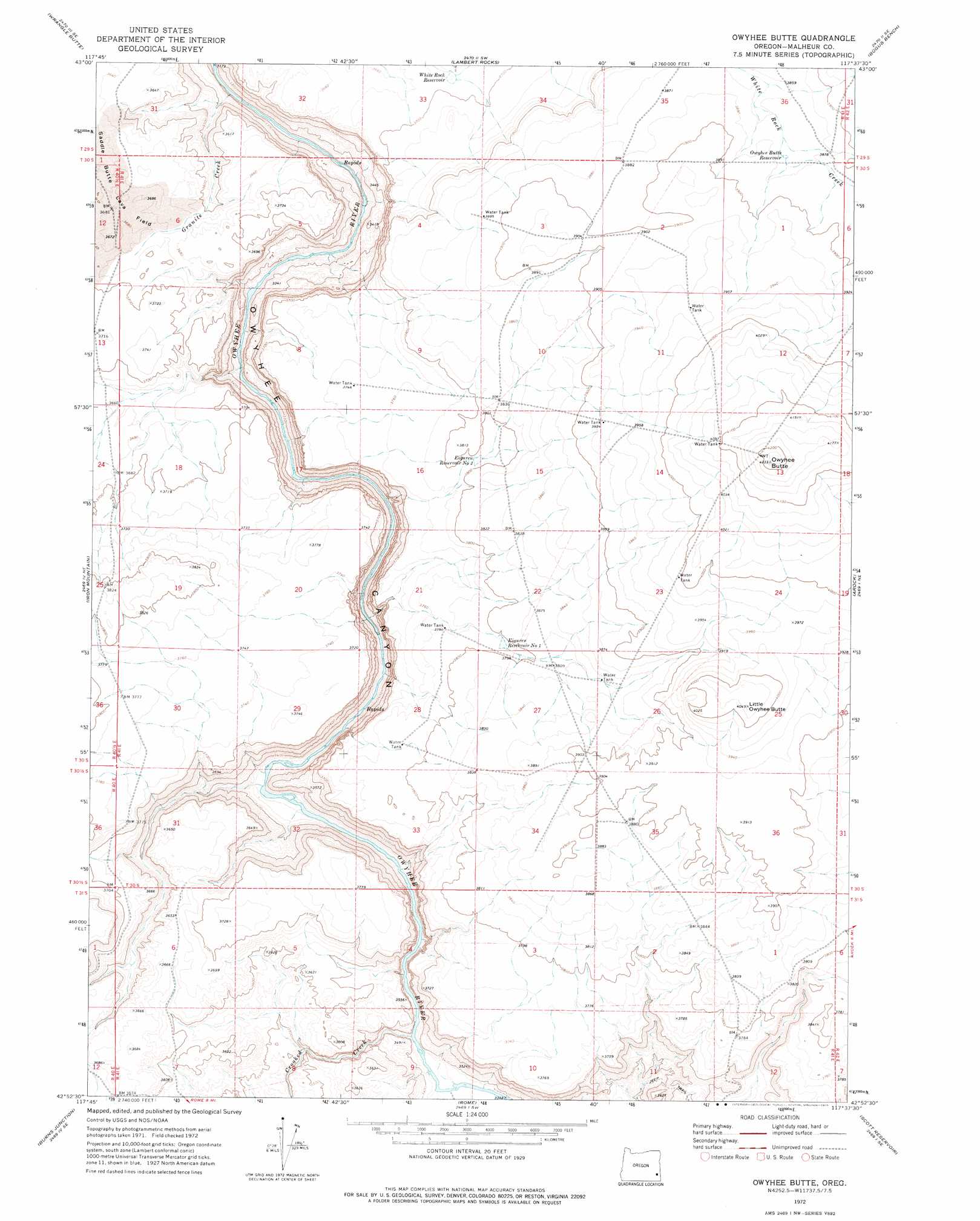
USGS Topo Quad 42117h6 - 1:24,000 scale
| Topo Map Name: | Owyhee Butte |
| USGS Topo Quad ID: | 42117h6 |
| Print Size: | ca. 21 1/4" wide x 27" high |
| Southeast Coordinates: | 42.875° N latitude / 117.625° W longitude |
| Map Center Coordinates: | 42.9375° N latitude / 117.6875° W longitude |
| U.S. State: | OR |
| Filename: | o42117h6.jpg |
| Download Map JPG Image: | Owyhee Butte topo map 1:24,000 scale |
| Map Type: | Topographic |
| Topo Series: | 7.5´ |
| Map Scale: | 1:24,000 |
| Source of Map Images: | United States Geological Survey (USGS) |
| Alternate Map Versions: |
Owyhee Butte OR 1972, updated 1975 Download PDF Buy paper map Owyhee Butte OR 2011 Download PDF Buy paper map Owyhee Butte OR 2014 Download PDF Buy paper map |
1:24,000 Topo Quads surrounding Owyhee Butte
Mustang Butte |
Sacramento Butte |
Rinehart Canyon |
The Hole In The Ground |
Jordan Craters North |
Saddle Butte |
Wrangle Butte |
Lambert Rocks |
Bogus Bench |
Jordan Craters South |
Palomino Lake |
Iron Mountain |
Owyhee Butte |
Arock |
Threemile Hill |
Palomino Hills |
Burns Junction |
Rome |
Scott Reservoir |
Dry Creek Rim |
Flat Top Mountain |
Anderson Reservoir |
The Basin |
Rockhouse Reservoir |
Indian Fort |
> Back to 42117e1 at 1:100,000 scale
> Back to 42116a1 at 1:250,000 scale
> Back to U.S. Topo Maps home
Owyhee Butte topo map: Gazetteer
Owyhee Butte: Canals
Zimmerman Ditch elevation 1203m 3946′Owyhee Butte: Post Offices
Bully Post Office (historical) elevation 1106m 3628′Owyhee Butte: Reservoirs
Eiguren Reservoir Number One elevation 1158m 3799′Eiguren Reservoir Number Two elevation 1158m 3799′
Owyhee Butte Reservoir elevation 1182m 3877′
White Rock Reservoir elevation 1123m 3684′
Owyhee Butte: Streams
Crooked Creek elevation 1019m 3343′Granite Creek elevation 970m 3182′
Owyhee Butte: Summits
Little Owyhee Butte elevation 1233m 4045′Owyhee Butte elevation 1288m 4225′
Owyhee Butte digital topo map on disk
Buy this Owyhee Butte topo map showing relief, roads, GPS coordinates and other geographical features, as a high-resolution digital map file on DVD: