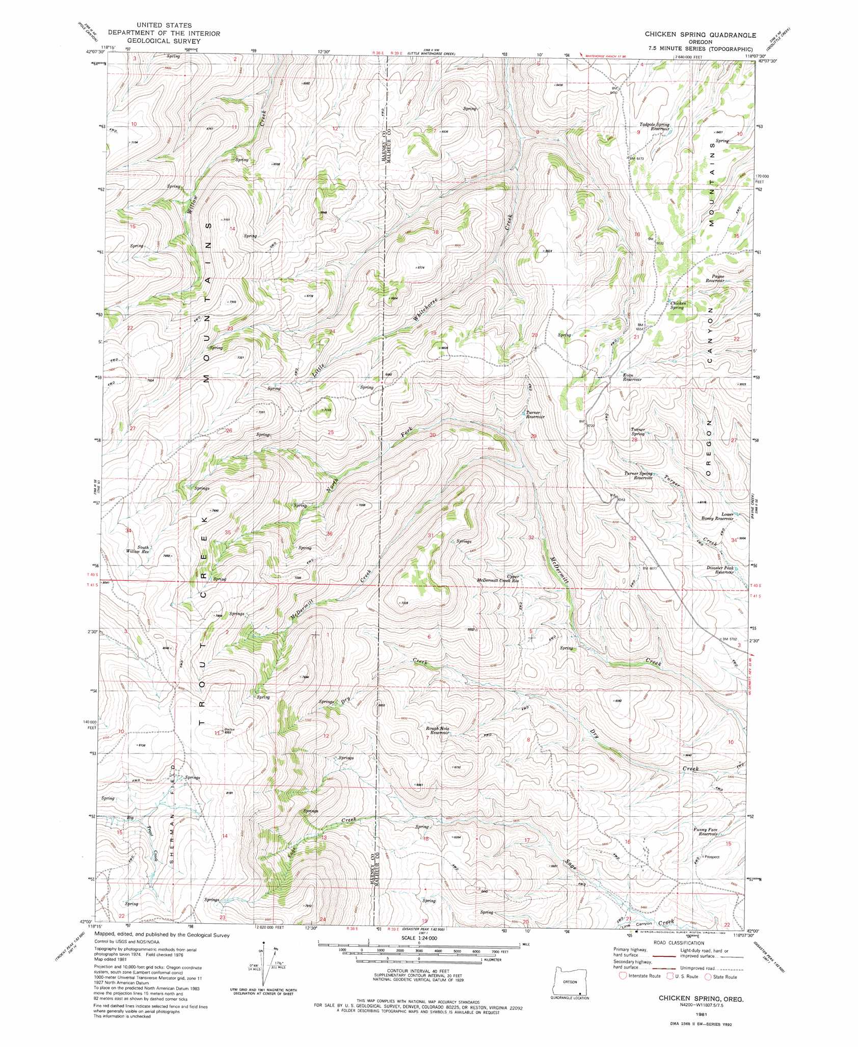
Chicken Spring Topo Map Oregon
To zoom in, hover over the map of Chicken Spring
USGS Topo Quad 42118a2 - 1:24,000 scale
| Topo Map Name: | Chicken Spring |
| USGS Topo Quad ID: | 42118a2 |
| Print Size: | ca. 21 1/4" wide x 27" high |
| Southeast Coordinates: | 42° N latitude / 118.125° W longitude |
| Map Center Coordinates: | 42.0625° N latitude / 118.1875° W longitude |
| U.S. State: | OR |
| Filename: | o42118a2.jpg |
| Download Map JPG Image: | Chicken Spring topo map 1:24,000 scale |
| Map Type: | Topographic |
| Topo Series: | 7.5´ |
| Map Scale: | 1:24,000 |
| Source of Map Images: | United States Geological Survey (USGS) |
| Alternate Map Versions: |
Chicken Spring OR 1981, updated 1982 Download PDF Buy paper map Chicken Spring OR 2011 Download PDF Buy paper map Chicken Spring OR 2014 Download PDF Buy paper map |
1:24,000 Topo Quads surrounding Chicken Spring
Red Lookout Butte |
Red Mountain |
Whitehorse Ranch |
Dry Creek Bench |
Blue Mountain Basin |
Trout Creek Canyon |
Pole Canyon |
Little Whitehorse Creek |
Doolittle Creek |
Oregon Canyon Ranch |
Windy Point |
The V |
Chicken Spring |
Payne Creek |
Bretz Mine |
Trident Peak |
Holloway Mountain |
Disaster Peak |
Washburn Basin |
Jordan Meadow Nw |
Shyster Butte |
Kings River Ranch |
Calavera Canyon |
Jordan Meadow Mountain |
Jordan Meadow |
> Back to 42118a1 at 1:100,000 scale
> Back to 42118a1 at 1:250,000 scale
> Back to U.S. Topo Maps home
Chicken Spring topo map: Gazetteer
Chicken Spring: Basins
Sherman Field elevation 2392m 7847′Chicken Spring: Reservoirs
Disaster Peak Reservoir elevation 1748m 5734′Evan Reservoir elevation 1998m 6555′
Funny Face Reservoir elevation 1644m 5393′
Lower Boney Reservoir elevation 1770m 5807′
Payne Reservoir elevation 1919m 6295′
Rough Hole Reservoir elevation 1922m 6305′
South Willow Reservoir elevation 2356m 7729′
Tadpole Spring Reservoir elevation 1933m 6341′
Turner Reservoir elevation 1877m 6158′
Turner Spring Reservoir elevation 1867m 6125′
Upper McDermitt Creek Reservoir elevation 1813m 5948′
Chicken Spring: Springs
Chicken Spring elevation 1988m 6522′Turner Spring elevation 1929m 6328′
Chicken Spring: Streams
North Fork McDermitt Creek elevation 1783m 5849′Chicken Spring digital topo map on disk
Buy this Chicken Spring topo map showing relief, roads, GPS coordinates and other geographical features, as a high-resolution digital map file on DVD: