Twelvemile Ridge Topo Map Oregon
To zoom in, hover over the map of Twelvemile Ridge
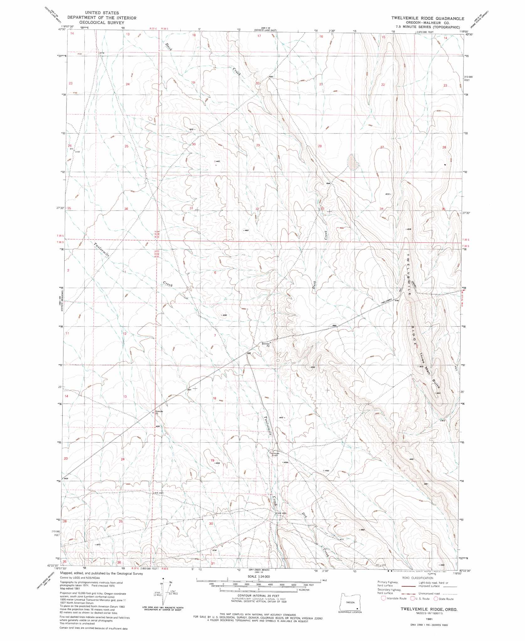
USGS Topo Quad 42118d1 - 1:24,000 scale
| Topo Map Name: | Twelvemile Ridge |
| USGS Topo Quad ID: | 42118d1 |
| Print Size: | ca. 21 1/4" wide x 27" high |
| Southeast Coordinates: | 42.375° N latitude / 118° W longitude |
| Map Center Coordinates: | 42.4375° N latitude / 118.0625° W longitude |
| U.S. State: | OR |
| Filename: | o42118d1.jpg |
| Download Map JPG Image: | Twelvemile Ridge topo map 1:24,000 scale |
| Map Type: | Topographic |
| Topo Series: | 7.5´ |
| Map Scale: | 1:24,000 |
| Source of Map Images: | United States Geological Survey (USGS) |
| Alternate Map Versions: |
Twelvemile Ridge OR 1981, updated 1981 Download PDF Buy paper map Twelvemile Ridge OR 2011 Download PDF Buy paper map Twelvemile Ridge OR 2014 Download PDF Buy paper map |
1:24,000 Topo Quads surrounding Twelvemile Ridge
Mickey Springs |
Ancient Lake Well |
Grassy Ridge Well |
Flat Top Mountain |
Anderson Reservoir |
Miranda Flat Se |
Coyote Lake West |
Coyote Lake East |
Rome State Airport |
Flat Top Mountain Se |
Tule Springs Ne |
Coyote Meadows |
Twelvemile Ridge |
Three Man Butte Well |
Basque |
Red Mountain |
Whitehorse Ranch |
Dry Creek Bench |
Blue Mountain Basin |
Blue Mountain Pass |
Pole Canyon |
Little Whitehorse Creek |
Doolittle Creek |
Oregon Canyon Ranch |
Bowden Waterhole |
> Back to 42118a1 at 1:100,000 scale
> Back to 42118a1 at 1:250,000 scale
> Back to U.S. Topo Maps home
Twelvemile Ridge topo map: Gazetteer
Twelvemile Ridge: Ridges
Twelvemile Ridge elevation 1495m 4904′Twelvemile Ridge: Slopes
Twelvemile Hill Grade elevation 1430m 4691′Twelvemile Ridge: Streams
Dry Creek elevation 1385m 4543′Twelvemile Creek elevation 1254m 4114′
Twelvemile Ridge: Summits
Three Man Butte elevation 1515m 4970′Twelvemile Ridge digital topo map on disk
Buy this Twelvemile Ridge topo map showing relief, roads, GPS coordinates and other geographical features, as a high-resolution digital map file on DVD: