Groan Canyon Topo Map Oregon
To zoom in, hover over the map of Groan Canyon
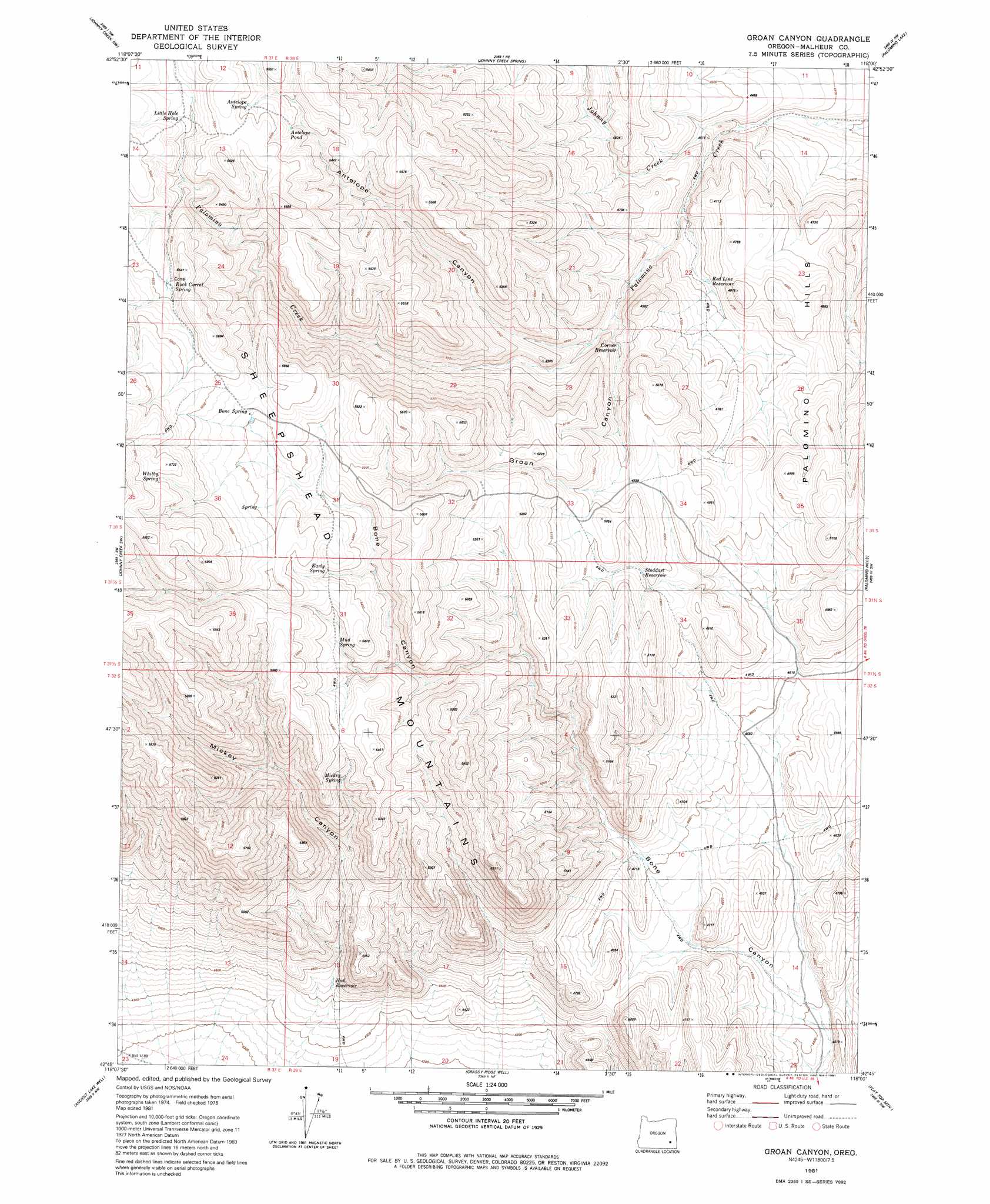
USGS Topo Quad 42118g1 - 1:24,000 scale
| Topo Map Name: | Groan Canyon |
| USGS Topo Quad ID: | 42118g1 |
| Print Size: | ca. 21 1/4" wide x 27" high |
| Southeast Coordinates: | 42.75° N latitude / 118° W longitude |
| Map Center Coordinates: | 42.8125° N latitude / 118.0625° W longitude |
| U.S. State: | OR |
| Filename: | o42118g1.jpg |
| Download Map JPG Image: | Groan Canyon topo map 1:24,000 scale |
| Map Type: | Topographic |
| Topo Series: | 7.5´ |
| Map Scale: | 1:24,000 |
| Source of Map Images: | United States Geological Survey (USGS) |
| Alternate Map Versions: |
Groan Canyon OR 1981, updated 1981 Download PDF Buy paper map Groan Canyon OR 2011 Download PDF Buy paper map Groan Canyon OR 2014 Download PDF Buy paper map |
1:24,000 Topo Quads surrounding Groan Canyon
Lambing Canyon |
Folly Farm |
Turnbull Peak |
Saddle Butte |
Wrangle Butte |
Juniper Lake |
Ryegrass Butte |
Johnny Creek Spring |
Palomino Lake |
Iron Mountain |
Coffin Butte |
Johnny Creek Sw |
Groan Canyon |
Palomino Hills |
Burns Junction |
Mickey Springs |
Ancient Lake Well |
Grassy Ridge Well |
Flat Top Mountain |
Anderson Reservoir |
Miranda Flat Se |
Coyote Lake West |
Coyote Lake East |
Rome State Airport |
Flat Top Mountain Se |
> Back to 42118e1 at 1:100,000 scale
> Back to 42118a1 at 1:250,000 scale
> Back to U.S. Topo Maps home
Groan Canyon topo map: Gazetteer
Groan Canyon: Reservoirs
Antelope Pond elevation 1650m 5413′Arrowhead Reservoir Number One elevation 1575m 5167′
Arrowhead Reservoir Number Three elevation 1493m 4898′
Arrowhead Reservoir Number Two elevation 1557m 5108′
Corner Reservoir elevation 1431m 4694′
Hub Reservoir elevation 1350m 4429′
Red Line Reservoir elevation 1396m 4580′
Stoddart Reservoir elevation 1496m 4908′
Groan Canyon: Springs
Antelope Spring elevation 1672m 5485′Bone Spring elevation 1682m 5518′
Early Spring elevation 1650m 5413′
Grasshopper Flat Spring elevation 1684m 5524′
Little Hole Spring elevation 1651m 5416′
Mickey Spring elevation 1585m 5200′
Mud Spring elevation 1628m 5341′
Whitby Spring elevation 1741m 5711′
Groan Canyon: Streams
Johnny Creek elevation 1369m 4491′Groan Canyon: Valleys
Bone Canyon elevation 1341m 4399′Groan Canyon elevation 1410m 4625′
Mickey Canyon elevation 1367m 4484′
Groan Canyon digital topo map on disk
Buy this Groan Canyon topo map showing relief, roads, GPS coordinates and other geographical features, as a high-resolution digital map file on DVD: