Krumbo Reservoir Topo Map Oregon
To zoom in, hover over the map of Krumbo Reservoir
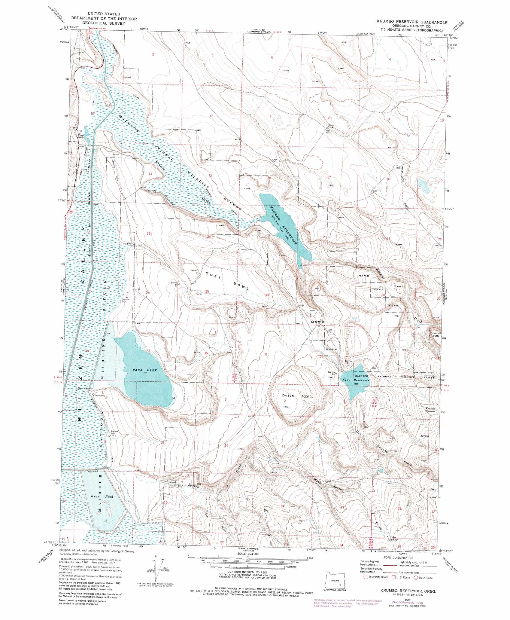
USGS Topo Quad 42118h7 - 1:24,000 scale
| Topo Map Name: | Krumbo Reservoir |
| USGS Topo Quad ID: | 42118h7 |
| Print Size: | ca. 21 1/4" wide x 27" high |
| Southeast Coordinates: | 42.875° N latitude / 118.75° W longitude |
| Map Center Coordinates: | 42.9375° N latitude / 118.8125° W longitude |
| U.S. State: | OR |
| Filename: | o42118h7.jpg |
| Download Map JPG Image: | Krumbo Reservoir topo map 1:24,000 scale |
| Map Type: | Topographic |
| Topo Series: | 7.5´ |
| Map Scale: | 1:24,000 |
| Source of Map Images: | United States Geological Survey (USGS) |
| Alternate Map Versions: |
Krumbo Reservoir OR 1967, updated 1972 Download PDF Buy paper map Krumbo Reservoir OR 1967, updated 1980 Download PDF Buy paper map Krumbo Reservoir OR 2011 Download PDF Buy paper map Krumbo Reservoir OR 2014 Download PDF Buy paper map |
1:24,000 Topo Quads surrounding Krumbo Reservoir
Southeast Harney Lake |
Coyote Buttes |
Jackass Butte Ne |
Barton Lake |
Adobe Flat |
Twin Buttes |
Jackass Butte |
Diamond Swamp |
Diamond |
Happy Valley |
Keg Sprs Valley East |
Irish Lake |
Krumbo Reservoir |
Krumbo Ridge |
Poison Springs |
Walls Lake |
Frenchglen |
Page Springs |
Mccoy Ridge |
Big Pasture Creek |
Butler Hill |
Roaring Springs |
Tombstone Canyon |
Fish Lake |
Wildhorse Lake |
> Back to 42118e1 at 1:100,000 scale
> Back to 42118a1 at 1:250,000 scale
> Back to U.S. Topo Maps home
Krumbo Reservoir topo map: Gazetteer
Krumbo Reservoir: Basins
Dust Bowl elevation 1289m 4229′Dutch Oven elevation 1350m 4429′
Krumbo Reservoir: Canals
Krumbo Canal elevation 1268m 4160′Krumbo Reservoir: Dams
Kern Brothers Dam elevation 1409m 4622′Krumbo Dam elevation 1281m 4202′
Krumbo Reservoir: Lakes
Baca Lake elevation 1265m 4150′Frazier Lake elevation 1348m 4422′
Krumbo Reservoir: Reservoirs
Bird Waterhole elevation 1267m 4156′Del Witzel Reservoir elevation 1390m 4560′
Kern Reservoir elevation 1409m 4622′
Knox Pond elevation 1269m 4163′
Krumbo Reservoir elevation 1281m 4202′
Larkspur Reservoir elevation 1301m 4268′
Lower Antelope Reservoir elevation 1427m 4681′
Lower Road Reservoir elevation 1370m 4494′
Krumbo Reservoir: Springs
Krumbo Springs elevation 1507m 4944′Webb Spring elevation 1513m 4963′
Krumbo Reservoir: Streams
Antelope Creek elevation 1348m 4422′Dry Krumbo Creek elevation 1285m 4215′
Krumbo Creek elevation 1266m 4153′
Webb Spring Creek elevation 1271m 4169′
Krumbo Reservoir: Valleys
Webb Canyon elevation 1414m 4639′Krumbo Reservoir: Wells
Hog Wallow Well elevation 1350m 4429′Krumbo Reservoir digital topo map on disk
Buy this Krumbo Reservoir topo map showing relief, roads, GPS coordinates and other geographical features, as a high-resolution digital map file on DVD: