Rabbit Hills Nw Topo Map Oregon
To zoom in, hover over the map of Rabbit Hills Nw
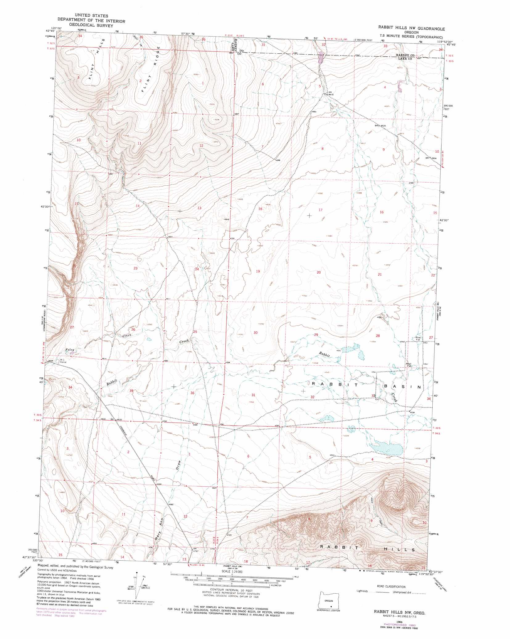
USGS Topo Quad 42119f8 - 1:24,000 scale
| Topo Map Name: | Rabbit Hills Nw |
| USGS Topo Quad ID: | 42119f8 |
| Print Size: | ca. 21 1/4" wide x 27" high |
| Southeast Coordinates: | 42.625° N latitude / 119.875° W longitude |
| Map Center Coordinates: | 42.6875° N latitude / 119.9375° W longitude |
| U.S. State: | OR |
| Filename: | o42119f8.jpg |
| Download Map JPG Image: | Rabbit Hills Nw topo map 1:24,000 scale |
| Map Type: | Topographic |
| Topo Series: | 7.5´ |
| Map Scale: | 1:24,000 |
| Source of Map Images: | United States Geological Survey (USGS) |
| Alternate Map Versions: |
Rabbit Hills NW OR 1966, updated 1969 Download PDF Buy paper map Rabbit Hills NW OR 1966, updated 1980 Download PDF Buy paper map Rabbit Hills NW OR 2011 Download PDF Buy paper map Rabbit Hills NW OR 2014 Download PDF Buy paper map |
1:24,000 Topo Quads surrounding Rabbit Hills Nw
Poverty Basin South |
Alkali Lake |
Juniper Mountain |
Turpin Knoll |
Red Bank Lakes |
Sawed Horn |
Coleman Hills |
Sagebrush Knoll |
Corn Lake |
Corporation Rim |
Lake Abert North |
Commodore Ridge |
Rabbit Hills Nw |
Rabbit Hills Ne |
Bluejoint Lake West |
Lake Abert South |
Cooper Draw |
Rabbit Hills Sw |
Flagstaff Lake |
Campbell Lake |
Little Honey Creek |
Drake Peak Ne |
Plush |
Hart Lake |
Warner Peak |
> Back to 42119e1 at 1:100,000 scale
> Back to 42118a1 at 1:250,000 scale
> Back to U.S. Topo Maps home
Rabbit Hills Nw topo map: Gazetteer
Rabbit Hills Nw: Basins
Rabbit Basin elevation 1385m 4543′Rabbit Hills Nw: Dams
Sherlock Gulch Dam elevation 1434m 4704′Rabbit Hills Nw: Reservoirs
Sherlock Gulch Reservoir elevation 1434m 4704′Rabbit Hills Nw: Streams
Foley Creek elevation 1397m 4583′Rabbit Hills Nw: Summits
Flint Hills elevation 1679m 5508′Rabbit Hills elevation 1617m 5305′
Rabbit Hills Nw: Valleys
Mary Ann Draw elevation 1393m 4570′Rabbit Hills Nw digital topo map on disk
Buy this Rabbit Hills Nw topo map showing relief, roads, GPS coordinates and other geographical features, as a high-resolution digital map file on DVD: