Orejana Canyon Topo Map Oregon
To zoom in, hover over the map of Orejana Canyon
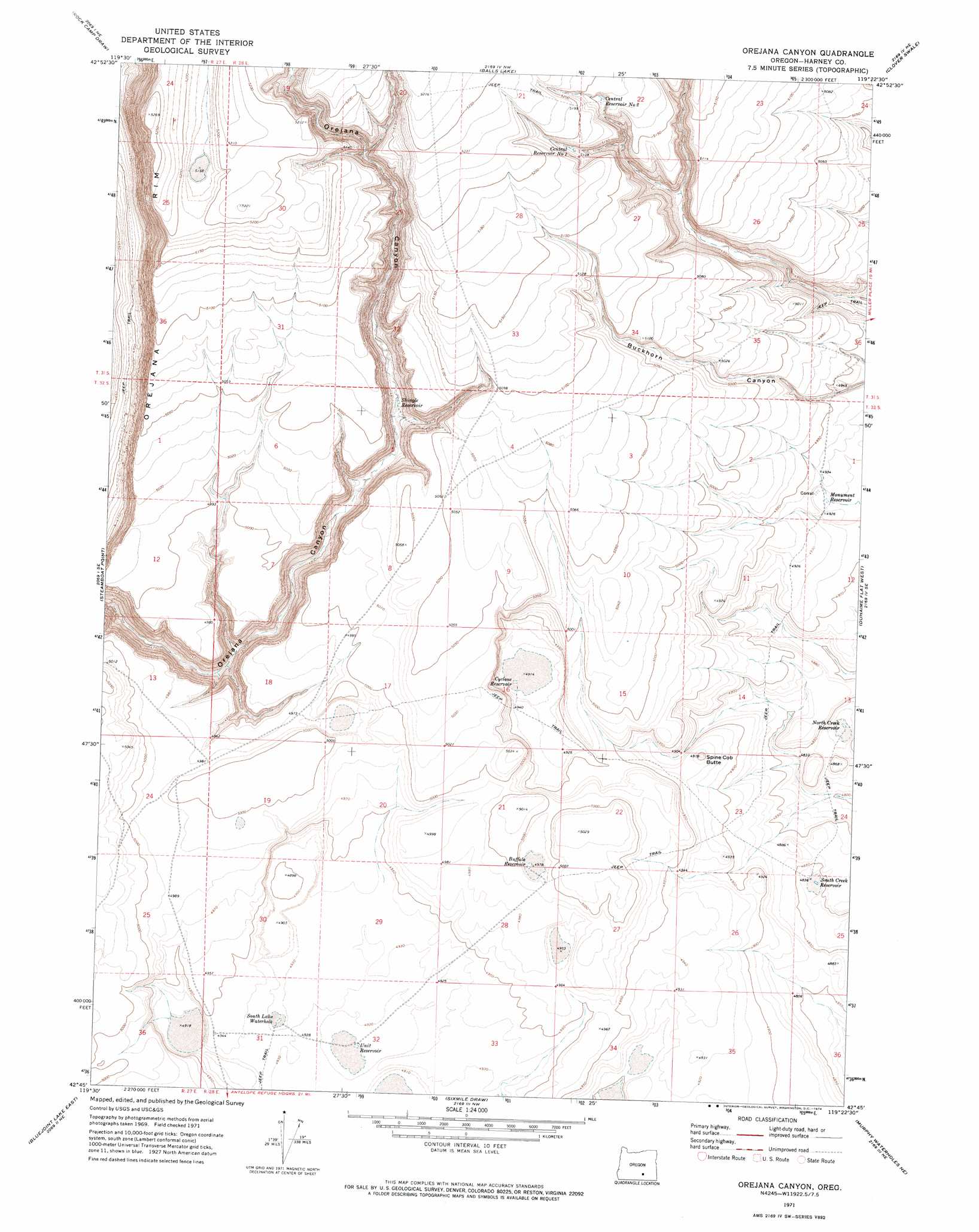
USGS Topo Quad 42119g4 - 1:24,000 scale
| Topo Map Name: | Orejana Canyon |
| USGS Topo Quad ID: | 42119g4 |
| Print Size: | ca. 21 1/4" wide x 27" high |
| Southeast Coordinates: | 42.75° N latitude / 119.375° W longitude |
| Map Center Coordinates: | 42.8125° N latitude / 119.4375° W longitude |
| U.S. State: | OR |
| Filename: | o42119g4.jpg |
| Download Map JPG Image: | Orejana Canyon topo map 1:24,000 scale |
| Map Type: | Topographic |
| Topo Series: | 7.5´ |
| Map Scale: | 1:24,000 |
| Source of Map Images: | United States Geological Survey (USGS) |
| Alternate Map Versions: |
Orejana Canyon OR 1971, updated 1974 Download PDF Buy paper map Orejana Canyon OR 2011 Download PDF Buy paper map Orejana Canyon OR 2014 Download PDF Buy paper map |
1:24,000 Topo Quads surrounding Orejana Canyon
Dry Valley Rim |
Rawhide Canyon |
Flybee Lake |
Meadow Lake |
Weed Lake Butte |
Red Bank Lakes |
Rock Camp Draw |
Balls Lake |
Clover Swale |
Keg Sprs Valley West |
Corporation Rim |
Steamboat Point |
Orejana Canyon |
Duhaime Flat West |
Duhaime Flat East |
Bluejoint Lake West |
Bluejoint Lake East |
Sixmile Draw |
Murphy Waterholes Ne |
Blitzen Nw |
Campbell Lake |
Flook Lake |
Murphy Waterholes |
Guano Reservoir |
Blitzen Sw |
> Back to 42119e1 at 1:100,000 scale
> Back to 42118a1 at 1:250,000 scale
> Back to U.S. Topo Maps home
Orejana Canyon topo map: Gazetteer
Orejana Canyon: Cliffs
Orejana Rim elevation 1465m 4806′Orejana Canyon: Lakes
South Lake Waterhole elevation 1504m 4934′Orejana Canyon: Reservoirs
Buffalo Reservoir elevation 1518m 4980′Central Reservoir Number One elevation 1565m 5134′
Central Reservoir Number Two elevation 1573m 5160′
Cyclone Reservoir elevation 1504m 4934′
Monument Reservoir elevation 1501m 4924′
North Creek Reservoir elevation 1469m 4819′
Shingle Reservoir elevation 1477m 4845′
South Creek Reservoir elevation 1476m 4842′
Unit Reservoir elevation 1499m 4917′
Orejana Canyon: Summits
Spine Cob Butte elevation 1509m 4950′Orejana Canyon digital topo map on disk
Buy this Orejana Canyon topo map showing relief, roads, GPS coordinates and other geographical features, as a high-resolution digital map file on DVD: