Steamboat Point Topo Map Oregon
To zoom in, hover over the map of Steamboat Point
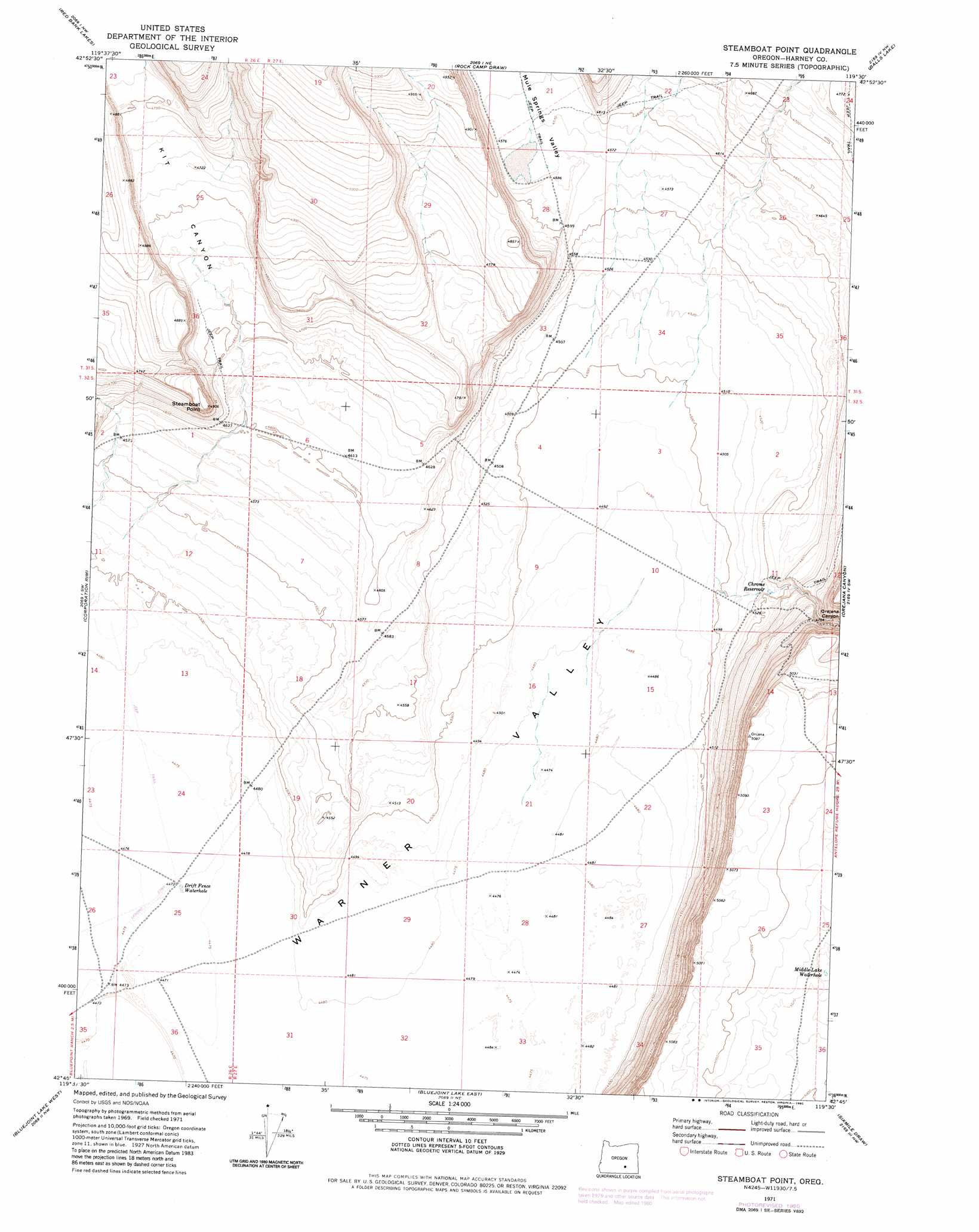
USGS Topo Quad 42119g5 - 1:24,000 scale
| Topo Map Name: | Steamboat Point |
| USGS Topo Quad ID: | 42119g5 |
| Print Size: | ca. 21 1/4" wide x 27" high |
| Southeast Coordinates: | 42.75° N latitude / 119.5° W longitude |
| Map Center Coordinates: | 42.8125° N latitude / 119.5625° W longitude |
| U.S. State: | OR |
| Filename: | o42119g5.jpg |
| Download Map JPG Image: | Steamboat Point topo map 1:24,000 scale |
| Map Type: | Topographic |
| Topo Series: | 7.5´ |
| Map Scale: | 1:24,000 |
| Source of Map Images: | United States Geological Survey (USGS) |
| Alternate Map Versions: |
Steamboat Point OR 1971, updated 1974 Download PDF Buy paper map Steamboat Point OR 1971, updated 1980 Download PDF Buy paper map Steamboat Point OR 2011 Download PDF Buy paper map Steamboat Point OR 2014 Download PDF Buy paper map |
1:24,000 Topo Quads surrounding Steamboat Point
Cox Canyon |
Dry Valley Rim |
Rawhide Canyon |
Flybee Lake |
Meadow Lake |
Turpin Knoll |
Red Bank Lakes |
Rock Camp Draw |
Balls Lake |
Clover Swale |
Corn Lake |
Corporation Rim |
Steamboat Point |
Orejana Canyon |
Duhaime Flat West |
Rabbit Hills Ne |
Bluejoint Lake West |
Bluejoint Lake East |
Sixmile Draw |
Murphy Waterholes Ne |
Flagstaff Lake |
Campbell Lake |
Flook Lake |
Murphy Waterholes |
Guano Reservoir |
> Back to 42119e1 at 1:100,000 scale
> Back to 42118a1 at 1:250,000 scale
> Back to U.S. Topo Maps home
Steamboat Point topo map: Gazetteer
Steamboat Point: Lakes
Middle Lake Waterhole elevation 1528m 5013′Steamboat Point: Reservoirs
Chrome Reservoir elevation 1382m 4534′Drift Fence Waterhole elevation 1365m 4478′
Steamboat Point: Summits
Steamboat Point elevation 1496m 4908′Steamboat Point: Valleys
Kit Canyon elevation 1403m 4603′Orejana Canyon elevation 1385m 4543′
Steamboat Point digital topo map on disk
Buy this Steamboat Point topo map showing relief, roads, GPS coordinates and other geographical features, as a high-resolution digital map file on DVD: