Keg Sprs Valley East Topo Map Oregon
To zoom in, hover over the map of Keg Sprs Valley East
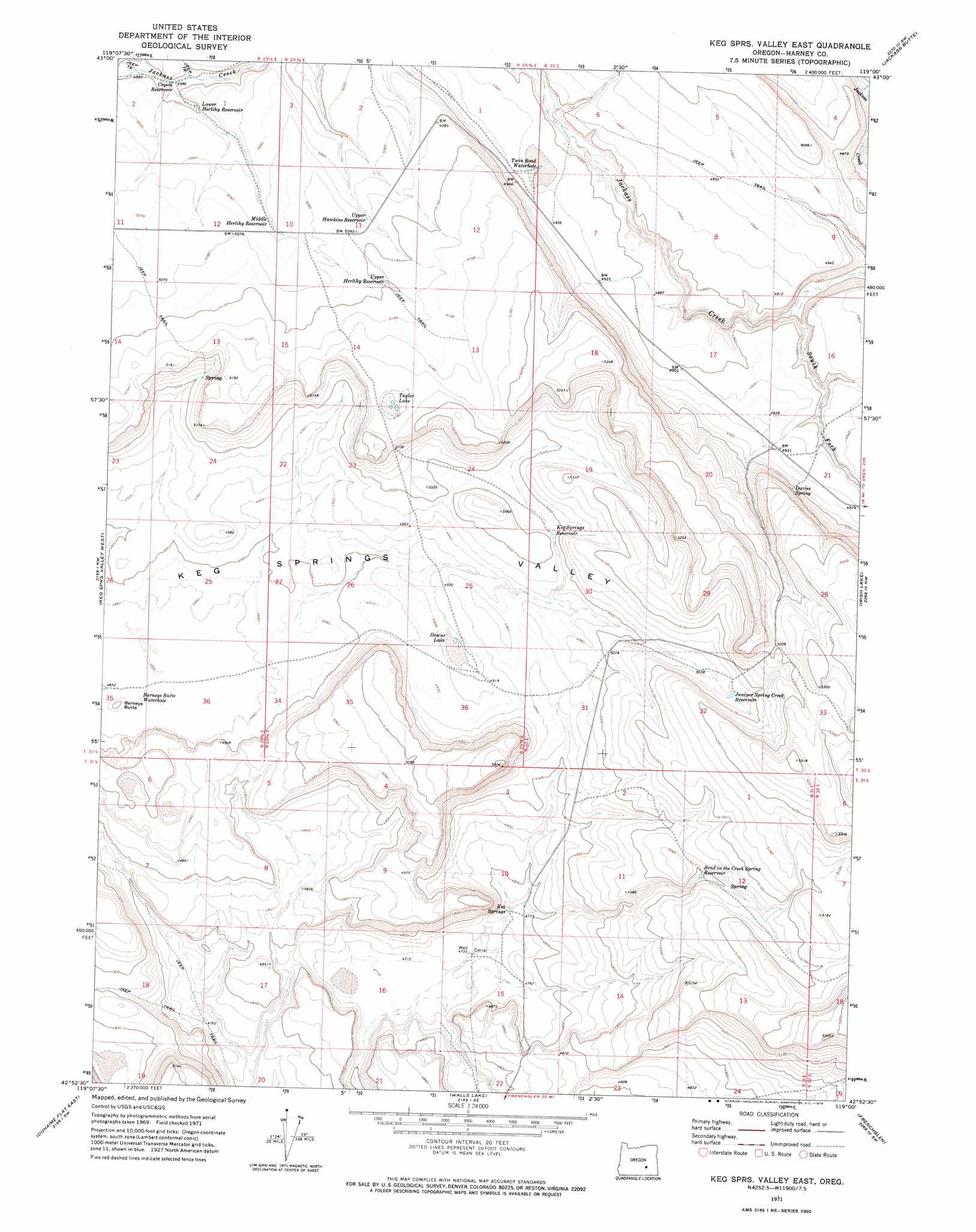
USGS Topo Quad 42119h1 - 1:24,000 scale
| Topo Map Name: | Keg Sprs Valley East |
| USGS Topo Quad ID: | 42119h1 |
| Print Size: | ca. 21 1/4" wide x 27" high |
| Southeast Coordinates: | 42.875° N latitude / 119° W longitude |
| Map Center Coordinates: | 42.9375° N latitude / 119.0625° W longitude |
| U.S. State: | OR |
| Filename: | o42119h1.jpg |
| Download Map JPG Image: | Keg Sprs Valley East topo map 1:24,000 scale |
| Map Type: | Topographic |
| Topo Series: | 7.5´ |
| Map Scale: | 1:24,000 |
| Source of Map Images: | United States Geological Survey (USGS) |
| Alternate Map Versions: |
Keg Sprs Valley East OR 1971, updated 1974 Download PDF Buy paper map Keg Springs Valley East OR 2011 Download PDF Buy paper map Keg Springs Valley East OR 2014 Download PDF Buy paper map |
1:24,000 Topo Quads surrounding Keg Sprs Valley East
Hughet Spring |
Southwest Harney Lake |
Southeast Harney Lake |
Coyote Buttes |
Jackass Butte Ne |
Meadow Lake |
Weed Lake Butte |
Twin Buttes |
Jackass Butte |
Diamond Swamp |
Clover Swale |
Keg Sprs Valley West |
Keg Sprs Valley East |
Irish Lake |
Krumbo Reservoir |
Duhaime Flat West |
Duhaime Flat East |
Walls Lake |
Frenchglen |
Page Springs |
Murphy Waterholes Ne |
Blitzen Nw |
Butler Hill |
Roaring Springs |
Tombstone Canyon |
> Back to 42119e1 at 1:100,000 scale
> Back to 42118a1 at 1:250,000 scale
> Back to U.S. Topo Maps home
Keg Sprs Valley East topo map: Gazetteer
Keg Sprs Valley East: Basins
Keg Springs Valley elevation 1489m 4885′Keg Sprs Valley East: Dams
Oscar Dam Number 4429 elevation 1471m 4826′Keg Sprs Valley East: Flats
Downs Lake elevation 1500m 4921′Keg Sprs Valley East: Lakes
Barneys Butte Waterhole elevation 1487m 4878′Taylor Lake elevation 1574m 5164′
Twin Road Waterhole elevation 1498m 4914′
Keg Sprs Valley East: Reservoirs
Bend in the Creek Spring Reservoir elevation 1523m 4996′Coyote Reservoir elevation 1522m 4993′
Juniper Spring Creek Reservoir elevation 1547m 5075′
Keg Springs Reservoir elevation 1525m 5003′
Lower Herlihy Reservoir elevation 1524m 5000′
Middle Herlihy Reservoir elevation 1544m 5065′
Oscar Reservoir Number 4429 elevation 1471m 4826′
Upper Hawkins Reservoir elevation 1550m 5085′
Upper Herlihy Reservoir elevation 1556m 5104′
Keg Sprs Valley East: Springs
Davies Spring elevation 1518m 4980′Keg Springs elevation 1454m 4770′
Keg Sprs Valley East: Streams
Juniper Creek elevation 1497m 4911′South Fork Jackass Creek elevation 1461m 4793′
Keg Sprs Valley East: Summits
Barneys Butte elevation 1496m 4908′Keg Sprs Valley East digital topo map on disk
Buy this Keg Sprs Valley East topo map showing relief, roads, GPS coordinates and other geographical features, as a high-resolution digital map file on DVD: