Lake Abert South Topo Map Oregon
To zoom in, hover over the map of Lake Abert South
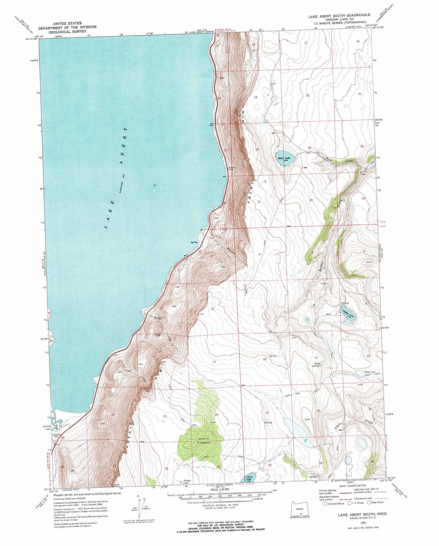
USGS Topo Quad 42120e2 - 1:24,000 scale
| Topo Map Name: | Lake Abert South |
| USGS Topo Quad ID: | 42120e2 |
| Print Size: | ca. 21 1/4" wide x 27" high |
| Southeast Coordinates: | 42.5° N latitude / 120.125° W longitude |
| Map Center Coordinates: | 42.5625° N latitude / 120.1875° W longitude |
| U.S. State: | OR |
| Filename: | o42120e2.jpg |
| Download Map JPG Image: | Lake Abert South topo map 1:24,000 scale |
| Map Type: | Topographic |
| Topo Series: | 7.5´ |
| Map Scale: | 1:24,000 |
| Source of Map Images: | United States Geological Survey (USGS) |
| Alternate Map Versions: |
Lake Abert South OR 1968, updated 1972 Download PDF Buy paper map Lake Abert South OR 1968, updated 1972 Download PDF Buy paper map Lake Abert South OR 2011 Download PDF Buy paper map Lake Abert South OR 2014 Download PDF Buy paper map |
1:24,000 Topo Quads surrounding Lake Abert South
Sharp Top |
Biscuit Point |
Sawed Horn |
Coleman Hills |
Sagebrush Knoll |
Coglan Buttes |
Coglan Buttes Ne |
Lake Abert North |
Commodore Ridge |
Rabbit Hills Nw |
Tucker Hill |
Coglan Buttes Se |
Lake Abert South |
Cooper Draw |
Rabbit Hills Sw |
Clover Flat |
Valley Falls |
Little Honey Creek |
Drake Peak Ne |
Plush |
Big Baldy |
Crooked Creek Valley |
Crook Peak |
Drake Peak |
Priday Reservoir |
> Back to 42120e1 at 1:100,000 scale
> Back to 42120a1 at 1:250,000 scale
> Back to U.S. Topo Maps home
Lake Abert South topo map: Gazetteer
Lake Abert South: Cliffs
Abert Rim elevation 1778m 5833′Lake Abert South: Lakes
Mule Lake elevation 1711m 5613′Priday Lake elevation 1992m 6535′
Webb Lake elevation 1819m 5967′
Lake Abert South: Parks
Abert Rim Historical Marker elevation 1311m 4301′Lake Abert South: Reservoirs
Colvin Lake elevation 1926m 6318′Fish Creek Waterhole Number Forty elevation 1908m 6259′
Fish Creek Waterhole Number Forty-seven elevation 1991m 6532′
Juniper Waterhole elevation 1943m 6374′
Lower Basin Draw Reservoir elevation 1737m 5698′
Paddys Lake elevation 1761m 5777′
Spawn Reservoir elevation 1955m 6414′
Lake Abert South: Springs
Sheep Creek Spring elevation 1734m 5688′Webb Springs elevation 1855m 6085′
Lake Abert South: Streams
Chewaucan River elevation 1298m 4258′Cold Creek elevation 1355m 4445′
Juniper Creek elevation 1298m 4258′
Poison Creek elevation 1298m 4258′
Lake Abert South: Valleys
Mule Draw elevation 1627m 5337′Lake Abert South: Woods
Colvin Timbers elevation 2003m 6571′Lake Abert South digital topo map on disk
Buy this Lake Abert South topo map showing relief, roads, GPS coordinates and other geographical features, as a high-resolution digital map file on DVD: