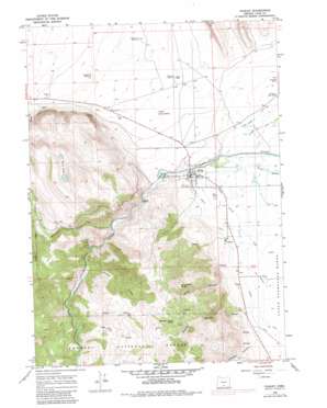
Paisley Topo Map Oregon
To zoom in, hover over the map of Paisley
USGS Topo Quad 42120f5 - 1:24,000 scale
| Topo Map Name: | Paisley |
| USGS Topo Quad ID: | 42120f5 |
| Print Size: | ca. 21 1/4" wide x 27" high |
| Southeast Coordinates: | 42.625° N latitude / 120.5° W longitude |
| Map Center Coordinates: | 42.6875° N latitude / 120.5625° W longitude |
| U.S. State: | OR |
| Filename: | o42120f5.jpg |
| Download Map JPG Image: | Paisley topo map 1:24,000 scale |
| Map Type: | Topographic |
| Topo Series: | 7.5´ |
| Map Scale: | 1:24,000 |
| Source of Map Images: | United States Geological Survey (USGS) |
| Alternate Map Versions: |
Paisley OR 1966, updated 1968 Download PDF Buy paper map Paisley OR 1966, updated 1980 Download PDF Buy paper map Paisley OR 1966, updated 1984 Download PDF Buy paper map Paisley OR 2004, updated 2007 Download PDF Buy paper map Paisley OR 2011 Download PDF Buy paper map Paisley OR 2014 Download PDF Buy paper map |
| FStopo: | US Forest Service topo Paisley is available: Download FStopo PDF Download FStopo TIF |
1:24,000 Topo Quads surrounding Paisley
> Back to 42120e1 at 1:100,000 scale
> Back to 42120a1 at 1:250,000 scale
> Back to U.S. Topo Maps home
Paisley topo map: Gazetteer
Paisley: Airports
Paisley State Airport elevation 1338m 4389′Paisley: Canals
Bagley Ditch elevation 1324m 4343′Conn Ditch elevation 1366m 4481′
Jones Canal elevation 1314m 4311′
Red House Ditch elevation 1321m 4333′
ZX Brattain Ditch elevation 1315m 4314′
Paisley: Flats
Paisley Flat elevation 1336m 4383′Paisley: Lakes
Twin Lakes elevation 1706m 5597′Paisley: Populated Places
Chewaucan (historical) elevation 1324m 4343′Paisley elevation 1332m 4370′
Paisley: Post Offices
Chewaucan Post Office (historical) elevation 1324m 4343′Paisley Post Office elevation 1332m 4370′
Paisley: Reservoirs
Admans Mill Pond elevation 1344m 4409′Paisley: Springs
Brattain Canyon Spring elevation 1786m 5859′Paisley: Streams
Juniper Creek elevation 1410m 4625′Mill Creek elevation 1387m 4550′
Sage Hen Creek elevation 1440m 4724′
Small Creek elevation 1338m 4389′
Paisley: Summits
Fir Timber Butte elevation 1935m 6348′Paisley: Valleys
Brattain Canyon elevation 1376m 4514′Coon Hollow elevation 1429m 4688′
Johnson Canyon elevation 1342m 4402′
Jones Canyon elevation 1385m 4543′
Paisley: Wells
Paisley Flat Well Number One elevation 1337m 4386′Paisley Flat Well Number Three elevation 1321m 4333′
Paisley Flat Well Number Two elevation 1328m 4356′
Paisley digital topo map on disk
Buy this Paisley topo map showing relief, roads, GPS coordinates and other geographical features, as a high-resolution digital map file on DVD:


