Slide Mountain Topo Map Oregon
To zoom in, hover over the map of Slide Mountain
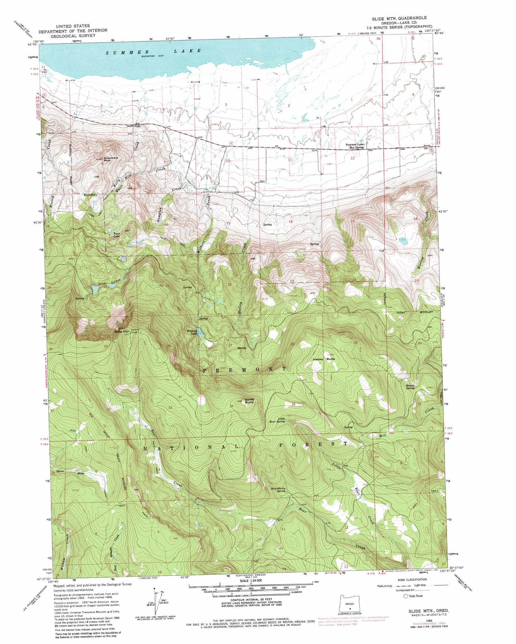
USGS Topo Quad 42120f6 - 1:24,000 scale
| Topo Map Name: | Slide Mountain |
| USGS Topo Quad ID: | 42120f6 |
| Print Size: | ca. 21 1/4" wide x 27" high |
| Southeast Coordinates: | 42.625° N latitude / 120.625° W longitude |
| Map Center Coordinates: | 42.6875° N latitude / 120.6875° W longitude |
| U.S. State: | OR |
| Filename: | o42120f6.jpg |
| Download Map JPG Image: | Slide Mountain topo map 1:24,000 scale |
| Map Type: | Topographic |
| Topo Series: | 7.5´ |
| Map Scale: | 1:24,000 |
| Source of Map Images: | United States Geological Survey (USGS) |
| Alternate Map Versions: |
Slide Mtn OR 1966, updated 1968 Download PDF Buy paper map Slide Mtn OR 1966, updated 1980 Download PDF Buy paper map Slide Mountain OR 2004, updated 2007 Download PDF Buy paper map Slide Mountain OR 2011 Download PDF Buy paper map Slide Mountain OR 2014 Download PDF Buy paper map |
| FStopo: | US Forest Service topo Slide Mountain is available: Download FStopo PDF Download FStopo TIF |
1:24,000 Topo Quads surrounding Slide Mountain
Foster Butte |
Summer Lake |
Ana River |
Diablo Peak |
Bull Lake |
Pole Butte |
Fremont Point |
South Of Ana River |
Loco Lake |
Sharp Top |
Shake Butte |
Harvey Creek |
Slide Mountain |
Paisley |
Coglan Buttes |
Sandhill Crossing |
Lee Thomas Crossing |
Coffeepot Creek |
Morgan Butte |
Tucker Hill |
Campbell Reservoir |
Gearhart Mountain |
Coleman Point |
Shoestring Butte |
Clover Flat |
> Back to 42120e1 at 1:100,000 scale
> Back to 42120a1 at 1:250,000 scale
> Back to U.S. Topo Maps home
Slide Mountain topo map: Gazetteer
Slide Mountain: Dams
Withers Dam elevation 1882m 6174′Slide Mountain: Lakes
Blue Lake elevation 1771m 5810′Slide Lakes elevation 1801m 5908′
Slide Mountain: Pillars
Monument Rock elevation 1663m 5456′Slide Mountain: Post Offices
Whitehill Post Office (historical) elevation 1286m 4219′Slide Mountain: Reservoirs
Potts Lake elevation 1701m 5580′Withers Lake elevation 1882m 6174′
Woodward Reservoir Number One elevation 1343m 4406′
Woodward Reservoir Number Two elevation 1331m 4366′
Slide Mountain: Springs
Gibson Hot Spring elevation 1278m 4192′Hanan Spring elevation 1884m 6181′
Little Bear Spring elevation 2090m 6856′
Strawberry Spring elevation 1924m 6312′
Summer Lake Hot Springs elevation 1301m 4268′
Slide Mountain: Streams
Hadley Creek elevation 1480m 4855′Hampton Creek elevation 1278m 4192′
Kelly Creek elevation 1265m 4150′
White Hill Creek elevation 1278m 4192′
Withers Creek elevation 1265m 4150′
Worlow Creek elevation 1312m 4304′
Slide Mountain: Summits
Hadley Butte elevation 2129m 6984′Sandy Butte elevation 2271m 7450′
Slide Mountain elevation 2366m 7762′
Slide Mountain: Trails
Hanan Trail elevation 2250m 7381′Slide Mountain digital topo map on disk
Buy this Slide Mountain topo map showing relief, roads, GPS coordinates and other geographical features, as a high-resolution digital map file on DVD: