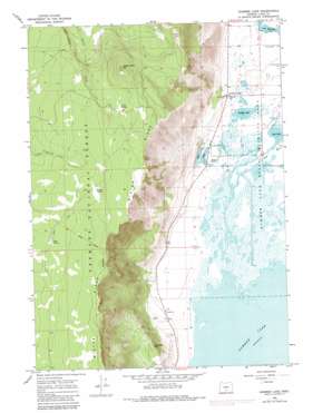
Summer Lake Topo Map Oregon
To zoom in, hover over the map of Summer Lake
USGS Topo Quad 42120h7 - 1:24,000 scale
| Topo Map Name: | Summer Lake |
| USGS Topo Quad ID: | 42120h7 |
| Print Size: | ca. 21 1/4" wide x 27" high |
| Southeast Coordinates: | 42.875° N latitude / 120.75° W longitude |
| Map Center Coordinates: | 42.9375° N latitude / 120.8125° W longitude |
| U.S. State: | OR |
| Filename: | o42120h7.jpg |
| Download Map JPG Image: | Summer Lake topo map 1:24,000 scale |
| Map Type: | Topographic |
| Topo Series: | 7.5´ |
| Map Scale: | 1:24,000 |
| Source of Map Images: | United States Geological Survey (USGS) |
| Alternate Map Versions: |
Summer Lake OR 1966, updated 1968 Download PDF Buy paper map Summer Lake OR 1966, updated 1980 Download PDF Buy paper map Summer Lake OR 1966, updated 1984 Download PDF Buy paper map Summer Lake OR 2004, updated 2007 Download PDF Buy paper map Summer Lake OR 2011 Download PDF Buy paper map Summer Lake OR 2014 Download PDF Buy paper map |
| FStopo: | US Forest Service topo Summer Lake is available: Download FStopo PDF Download FStopo TIF |
1:24,000 Topo Quads surrounding Summer Lake
> Back to 42120e1 at 1:100,000 scale
> Back to 42120a1 at 1:250,000 scale
> Back to U.S. Topo Maps home
Summer Lake topo map: Gazetteer
Summer Lake: Canals
Summer Lake I D Canal elevation 1303m 4274′Summer Lake: Cliffs
Dead Indian Rim elevation 1877m 6158′Summer Lake: Lakes
Dutchy Lake elevation 1272m 4173′Jacks Lakes elevation 1274m 4179′
Leyva Lakes elevation 1275m 4183′
Rest Lake elevation 1267m 4156′
Summer Lake: Levees
Bullgate Dike elevation 1266m 4153′Summer Lake: Parks
Summer Lake State Wildlife Area elevation 1268m 4160′Summer Lake: Populated Places
Summer Lake elevation 1289m 4229′Summer Lake: Post Offices
Summer Lake Post Office elevation 1289m 4229′Summer Lake: Reservoirs
Foster Reservoirs elevation 1271m 4169′Summer Lake: Springs
Bagley Spring elevation 2026m 6646′Bottle Spring elevation 1982m 6502′
Dead Indian Spring elevation 1930m 6332′
Foster Spring elevation 1295m 4248′
Lewis Spring elevation 2020m 6627′
Summer Lake: Streams
Ana River elevation 1265m 4150′Summer Lake: Summits
Campbell Hill elevation 1536m 5039′Dead Indian Mountain elevation 2137m 7011′
Summer Lake digital topo map on disk
Buy this Summer Lake topo map showing relief, roads, GPS coordinates and other geographical features, as a high-resolution digital map file on DVD:


