Klamath Falls Topo Map Oregon
To zoom in, hover over the map of Klamath Falls
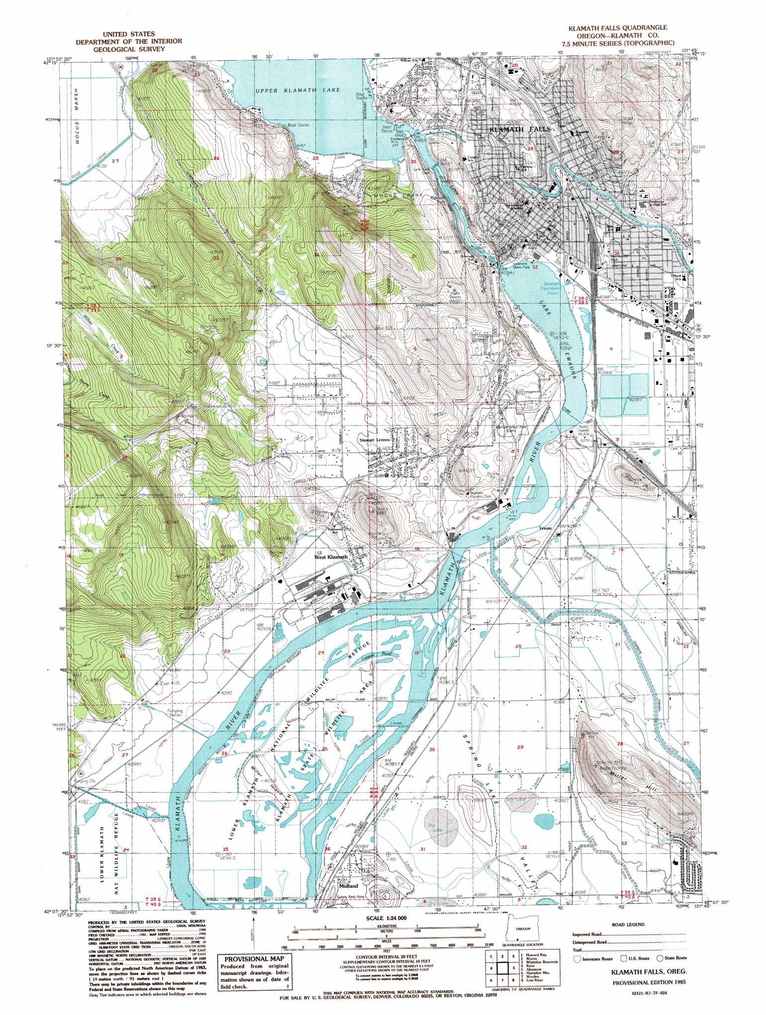
USGS Topo Quad 42121b7 - 1:24,000 scale
| Topo Map Name: | Klamath Falls |
| USGS Topo Quad ID: | 42121b7 |
| Print Size: | ca. 21 1/4" wide x 27" high |
| Southeast Coordinates: | 42.125° N latitude / 121.75° W longitude |
| Map Center Coordinates: | 42.1875° N latitude / 121.8125° W longitude |
| U.S. State: | OR |
| Filename: | o42121b7.jpg |
| Download Map JPG Image: | Klamath Falls topo map 1:24,000 scale |
| Map Type: | Topographic |
| Topo Series: | 7.5´ |
| Map Scale: | 1:24,000 |
| Source of Map Images: | United States Geological Survey (USGS) |
| Alternate Map Versions: |
Klamath Falls NE OR 1975, updated 1981 Download PDF Buy paper map Klamath Falls OR 1985, updated 1985 Download PDF Buy paper map Klamath Falls OR 2011 Download PDF Buy paper map Klamath Falls OR 2014 Download PDF Buy paper map |
1:24,000 Topo Quads surrounding Klamath Falls
Pelican Bay |
Shoalwater Bay |
Modoc Point |
Swan Lake Point |
Sprague River West |
Aspen Lake |
Howard Bay |
Wocus |
Whiteline Reservoir |
Swan Lake |
Spencer Creek |
Keno |
Klamath Falls |
Altamont |
Dairy |
Chicken Hills |
Hamaker Mountain |
Worden |
Lost River |
Merrill |
Sams Neck |
Dorris |
Sheepy Lake |
Lower Klamath Lake |
Hatfield |
> Back to 42121a1 at 1:100,000 scale
> Back to 42120a1 at 1:250,000 scale
> Back to U.S. Topo Maps home
Klamath Falls topo map: Gazetteer
Klamath Falls: Bridges
Fremont Bridge elevation 1264m 4146′Klamath Falls: Canals
Keno Canal elevation 1258m 4127′Plevna Ditch elevation 1256m 4120′
Klamath Falls: Dams
Link River Dam elevation 1249m 4097′Klamath Falls: Falls
Klamath Falls elevation 1254m 4114′Klamath Falls: Islands
Miller Island elevation 1249m 4097′Klamath Falls: Lakes
Lake Ewauna elevation 1247m 4091′Klamath Falls: Parks
Conger Heights Park elevation 1306m 4284′Conger School Park elevation 1270m 4166′
Eldorado Park elevation 1259m 4130′
Ella Redkey Municipal Pool elevation 1257m 4124′
Fairview Park elevation 1277m 4189′
Henderson Park elevation 1265m 4150′
Kit Carson Park elevation 1273m 4176′
Klamath Game Management Area elevation 1248m 4094′
Klein Park elevation 1248m 4094′
Krause Park elevation 1292m 4238′
Mills Little League Park elevation 1249m 4097′
Mills-Kiwanis Park elevation 1252m 4107′
Moore Park elevation 1328m 4356′
Pacific Terrace Park elevation 1278m 4192′
Putnams Point elevation 1265m 4150′
Richmond Park elevation 1268m 4160′
Stukel Park elevation 1256m 4120′
Veterans Memorial Park elevation 1248m 4094′
Warford Park elevation 1287m 4222′
Wocus Bay Boat Launch elevation 1287m 4222′
Klamath Falls: Populated Places
Fairhaven elevation 1286m 4219′Falcon Heights elevation 1346m 4416′
Klamath Falls elevation 1252m 4107′
Merganser (historical) elevation 1253m 4110′
Midland elevation 1250m 4101′
Stewart Lenox elevation 1291m 4235′
West Klamath (historical) elevation 1252m 4107′
Klamath Falls: Post Offices
Klamath Falls Post Office elevation 1250m 4101′Merganser Post Office (historical) elevation 1253m 4110′
Midland Post Office elevation 1250m 4101′
Klamath Falls: Reservoirs
Botens Reservoir elevation 1270m 4166′Klamath Falls: Streams
Link River elevation 1247m 4091′Klamath Falls: Summits
Miller Hill elevation 1369m 4491′Klamath Falls: Trails
OC&E Woods Line State Trail elevation 1252m 4107′Klamath Falls: Valleys
Spring Lake Valley elevation 1248m 4094′Klamath Falls digital topo map on disk
Buy this Klamath Falls topo map showing relief, roads, GPS coordinates and other geographical features, as a high-resolution digital map file on DVD: