Dry Prairie Topo Map Oregon
To zoom in, hover over the map of Dry Prairie
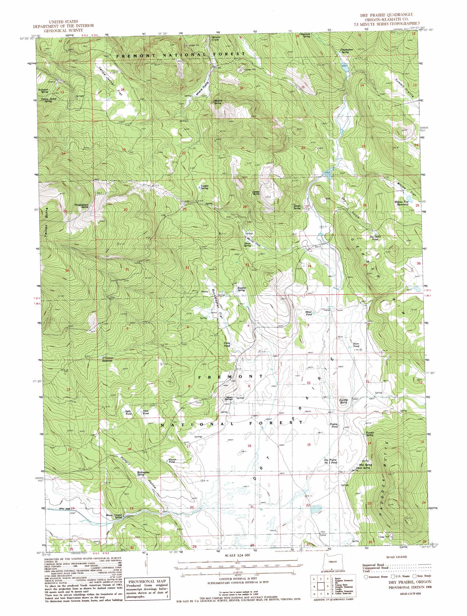
USGS Topo Quad 42121c2 - 1:24,000 scale
| Topo Map Name: | Dry Prairie |
| USGS Topo Quad ID: | 42121c2 |
| Print Size: | ca. 21 1/4" wide x 27" high |
| Southeast Coordinates: | 42.25° N latitude / 121.125° W longitude |
| Map Center Coordinates: | 42.3125° N latitude / 121.1875° W longitude |
| U.S. State: | OR |
| Filename: | o42121c2.jpg |
| Download Map JPG Image: | Dry Prairie topo map 1:24,000 scale |
| Map Type: | Topographic |
| Topo Series: | 7.5´ |
| Map Scale: | 1:24,000 |
| Source of Map Images: | United States Geological Survey (USGS) |
| Alternate Map Versions: |
Dry Prairie OR 1988, updated 1988 Download PDF Buy paper map Dry Prairie OR 2011 Download PDF Buy paper map Dry Prairie OR 2014 Download PDF Buy paper map |
| FStopo: | US Forest Service topo Dry Prairie is available: Download FStopo PDF Download FStopo TIF |
1:24,000 Topo Quads surrounding Dry Prairie
Cooks Mountain |
Spodue Mountain |
Ponina Butte |
Rodeo Butte |
Sandhill Crossing |
Sprague River East |
Beatty |
Ferguson Mountain |
Bly |
Campbell Reservoir |
Yonna |
Yainax Butte |
Dry Prairie |
Horsefly Mountain |
Paradise Mountain |
Bonanza |
Lorella |
Goodlow Mountain |
Gerber Reservoir |
Barnes Valley |
Malin |
Bryant Mountain |
Langell Valley |
Brady Butte |
Antler Point |
> Back to 42121a1 at 1:100,000 scale
> Back to 42120a1 at 1:250,000 scale
> Back to U.S. Topo Maps home
Dry Prairie topo map: Gazetteer
Dry Prairie: Cliffs
Gerber Rim elevation 1563m 5127′Dry Prairie: Flats
Dry Prairie elevation 1479m 4852′Mineral Prairie elevation 1528m 5013′
Murray Field elevation 1531m 5022′
Summit Prairie elevation 1605m 5265′
Willow Flat elevation 1558m 5111′
Yellow Jacket Flat elevation 1619m 5311′
Dry Prairie: Lakes
Dry Gulch Pond elevation 1561m 5121′Dry Prairie Number One Pond elevation 1480m 4855′
Forty Pond elevation 1488m 4881′
Gully Pond elevation 1543m 5062′
Horn Pond elevation 1484m 4868′
Miner Pond elevation 1485m 4872′
Prairie Pond elevation 1481m 4858′
Vinson Pond elevation 1495m 4904′
Dry Prairie: Post Offices
Royston Post Office (historical) elevation 1504m 4934′Dry Prairie: Reservoirs
Near Pond elevation 1533m 5029′O'Connor Reservoir elevation 1610m 5282′
Willow Flat Reservoir elevation 1558m 5111′
Dry Prairie: Springs
Buckmaster Spring elevation 1500m 4921′Chipmunk Spring elevation 1579m 5180′
Dead Spring elevation 1495m 4904′
Goop Spring elevation 1505m 4937′
Horse Canyon Spring elevation 1499m 4917′
James Spring elevation 1497m 4911′
Manhattan Spring elevation 1588m 5209′
Mineral Spring elevation 1585m 5200′
Nuthatch Springs elevation 1570m 5150′
Painter Spring elevation 1506m 4940′
Royston Spring elevation 1500m 4921′
Seven Springs elevation 1482m 4862′
Thimbleberry Spring elevation 1790m 5872′
Tumble Spring elevation 1574m 5164′
Wild Spring elevation 1494m 4901′
Yellow Jacket Spring elevation 1594m 5229′
Dry Prairie: Summits
Coyote Butte elevation 1496m 4908′James Butte elevation 1633m 5357′
Paddock Butte elevation 1675m 5495′
Dry Prairie: Swamps
Buckmaster Flat elevation 1495m 4904′Dry Prairie: Valleys
Dry Gulch elevation 1509m 4950′Hungry Hollow elevation 1484m 4868′
Dry Prairie: Wells
Deadman Well elevation 1538m 5045′Dry Prairie digital topo map on disk
Buy this Dry Prairie topo map showing relief, roads, GPS coordinates and other geographical features, as a high-resolution digital map file on DVD: