Howard Bay Topo Map Oregon
To zoom in, hover over the map of Howard Bay
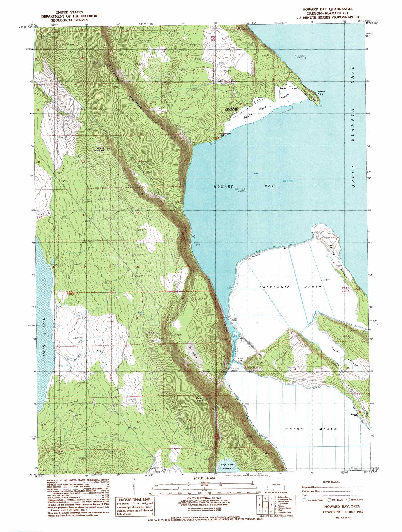
USGS Topo Quad 42121c8 - 1:24,000 scale
| Topo Map Name: | Howard Bay |
| USGS Topo Quad ID: | 42121c8 |
| Print Size: | ca. 21 1/4" wide x 27" high |
| Southeast Coordinates: | 42.25° N latitude / 121.875° W longitude |
| Map Center Coordinates: | 42.3125° N latitude / 121.9375° W longitude |
| U.S. State: | OR |
| Filename: | o42121c8.jpg |
| Download Map JPG Image: | Howard Bay topo map 1:24,000 scale |
| Map Type: | Topographic |
| Topo Series: | 7.5´ |
| Map Scale: | 1:24,000 |
| Source of Map Images: | United States Geological Survey (USGS) |
| Alternate Map Versions: |
Howard Bay OR 1985, updated 1985 Download PDF Buy paper map Howard Bay OR 2011 Download PDF Buy paper map Howard Bay OR 2014 Download PDF Buy paper map |
1:24,000 Topo Quads surrounding Howard Bay
Pelican Butte |
Crystal Spring |
Agency Lake |
Chiloquin |
S'Ocholis Canyon |
Lake Of The Woods North |
Pelican Bay |
Shoalwater Bay |
Modoc Point |
Swan Lake Point |
Lake Of The Woods South |
Aspen Lake |
Howard Bay |
Wocus |
Whiteline Reservoir |
Surveyor Mountain |
Spencer Creek |
Keno |
Klamath Falls |
Altamont |
Mule Hill |
Chicken Hills |
Hamaker Mountain |
Worden |
Lost River |
> Back to 42121a1 at 1:100,000 scale
> Back to 42120a1 at 1:250,000 scale
> Back to U.S. Topo Maps home
Howard Bay topo map: Gazetteer
Howard Bay: Basins
Bear Wallow elevation 1327m 4353′Howard Bay: Bays
Howard Bay elevation 1264m 4146′Howard Bay: Canals
Caledonia Canal elevation 1264m 4146′Howard Bay: Capes
Sesti Tgawaals Point elevation 1291m 4235′Skillet Handle elevation 1270m 4166′
Howard Bay: Levees
Caledonia Dike elevation 1264m 4146′Cross Dike elevation 1263m 4143′
Howard Bay: Parks
Howard Bay Park elevation 1264m 4146′Howard Bay: Reservoirs
Melvins Pond elevation 1264m 4146′Howard Bay: Streams
Lajeunesse Creek elevation 1318m 4324′Howard Bay: Summits
Doak Mountain elevation 1456m 4776′Porter Butte elevation 1691m 5547′
Spence Mountain elevation 1783m 5849′
Howard Bay: Swamps
Caledonia Marsh elevation 1261m 4137′Sesti Tgawaals Marsh elevation 1266m 4153′
Wocus Marsh elevation 1260m 4133′
Howard Bay: Valleys
Payne Canyon elevation 1260m 4133′Howard Bay digital topo map on disk
Buy this Howard Bay topo map showing relief, roads, GPS coordinates and other geographical features, as a high-resolution digital map file on DVD: