Shoalwater Bay Topo Map Oregon
To zoom in, hover over the map of Shoalwater Bay
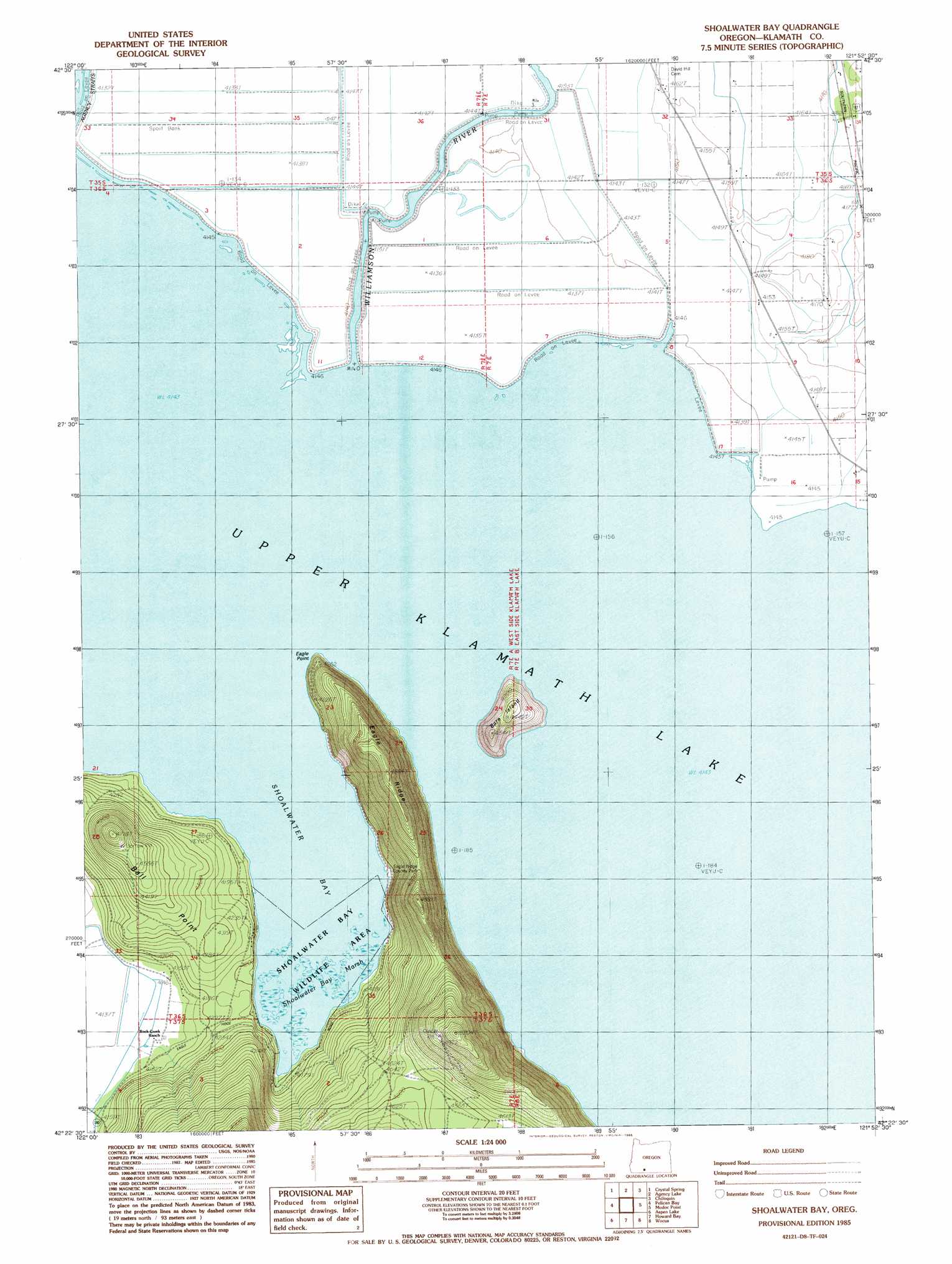
USGS Topo Quad 42121d8 - 1:24,000 scale
| Topo Map Name: | Shoalwater Bay |
| USGS Topo Quad ID: | 42121d8 |
| Print Size: | ca. 21 1/4" wide x 27" high |
| Southeast Coordinates: | 42.375° N latitude / 121.875° W longitude |
| Map Center Coordinates: | 42.4375° N latitude / 121.9375° W longitude |
| U.S. State: | OR |
| Filename: | o42121d8.jpg |
| Download Map JPG Image: | Shoalwater Bay topo map 1:24,000 scale |
| Map Type: | Topographic |
| Topo Series: | 7.5´ |
| Map Scale: | 1:24,000 |
| Source of Map Images: | United States Geological Survey (USGS) |
| Alternate Map Versions: |
Shoalwater Bay OR 1985, updated 1985 Download PDF Buy paper map Shoalwater Bay OR 2011 Download PDF Buy paper map Shoalwater Bay OR 2014 Download PDF Buy paper map |
| FStopo: | US Forest Service topo Shoalwater Bay is available: Download FStopo PDF Download FStopo TIF |
1:24,000 Topo Quads surrounding Shoalwater Bay
Devils Peak |
Mares Egg Spring |
Fort Klamath |
Soloman Butte |
Applegate Butte |
Pelican Butte |
Crystal Spring |
Agency Lake |
Chiloquin |
S'Ocholis Canyon |
Lake Of The Woods North |
Pelican Bay |
Shoalwater Bay |
Modoc Point |
Swan Lake Point |
Lake Of The Woods South |
Aspen Lake |
Howard Bay |
Wocus |
Whiteline Reservoir |
Surveyor Mountain |
Spencer Creek |
Keno |
Klamath Falls |
Altamont |
> Back to 42121a1 at 1:100,000 scale
> Back to 42120a1 at 1:250,000 scale
> Back to U.S. Topo Maps home
Shoalwater Bay topo map: Gazetteer
Shoalwater Bay: Bays
Shoalwater Bay elevation 1264m 4146′Shoalwater Bay: Capes
Eagle Point elevation 1293m 4242′Shoalwater Bay: Islands
Bare Island elevation 1348m 4422′Shoalwater Bay: Lakes
Upper Klamath Lake elevation 1264m 4146′Shoalwater Bay: Parks
Eagle Ridge County Park elevation 1269m 4163′Shoalwater Bay: Pillars
Jumping Rock elevation 1264m 4146′Shoalwater Bay: Ridges
Eagle Ridge elevation 1481m 4858′Shoalwater Bay: Streams
Williamson River elevation 1264m 4146′Shoalwater Bay: Swamps
Shoalwater Bay Marsh elevation 1264m 4146′Shoalwater Bay digital topo map on disk
Buy this Shoalwater Bay topo map showing relief, roads, GPS coordinates and other geographical features, as a high-resolution digital map file on DVD: