Chiloquin Topo Map Oregon
To zoom in, hover over the map of Chiloquin
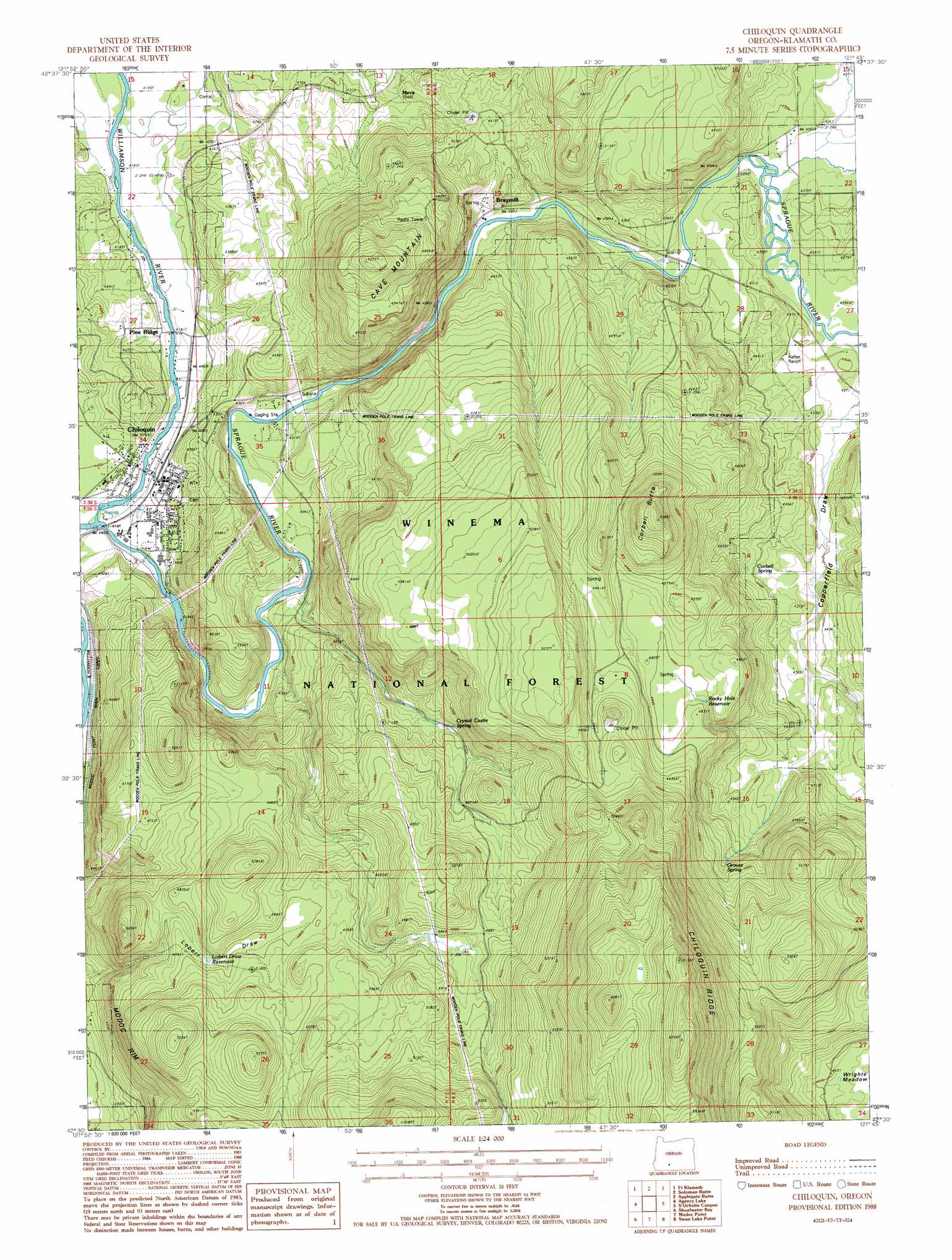
USGS Topo Quad 42121e7 - 1:24,000 scale
| Topo Map Name: | Chiloquin |
| USGS Topo Quad ID: | 42121e7 |
| Print Size: | ca. 21 1/4" wide x 27" high |
| Southeast Coordinates: | 42.5° N latitude / 121.75° W longitude |
| Map Center Coordinates: | 42.5625° N latitude / 121.8125° W longitude |
| U.S. State: | OR |
| Filename: | o42121e7.jpg |
| Download Map JPG Image: | Chiloquin topo map 1:24,000 scale |
| Map Type: | Topographic |
| Topo Series: | 7.5´ |
| Map Scale: | 1:24,000 |
| Source of Map Images: | United States Geological Survey (USGS) |
| Alternate Map Versions: |
Chiloquin OR 1988, updated 1988 Download PDF Buy paper map Chiloquin OR 1998, updated 2000 Download PDF Buy paper map Chiloquin OR 2011 Download PDF Buy paper map Chiloquin OR 2014 Download PDF Buy paper map |
| FStopo: | US Forest Service topo Chiloquin is available: Download FStopo PDF Download FStopo TIF |
1:24,000 Topo Quads surrounding Chiloquin
Maklaks Crater |
Sun Pass |
Fuego |
Wocus Bay |
Buckhorn Springs |
Mares Egg Spring |
Fort Klamath |
Soloman Butte |
Applegate Butte |
Calimus Butte |
Crystal Spring |
Agency Lake |
Chiloquin |
S'Ocholis Canyon |
Buttes Of The Gods |
Pelican Bay |
Shoalwater Bay |
Modoc Point |
Swan Lake Point |
Sprague River West |
Aspen Lake |
Howard Bay |
Wocus |
Whiteline Reservoir |
Swan Lake |
> Back to 42121e1 at 1:100,000 scale
> Back to 42120a1 at 1:250,000 scale
> Back to U.S. Topo Maps home
Chiloquin topo map: Gazetteer
Chiloquin: Areas
Special Trust Land elevation 1350m 4429′Chiloquin: Channels
Chiloquin Narrows elevation 1380m 4527′Chiloquin: Mines
Braymill Cinder Pit elevation 1351m 4432′Corbell Cinder Pit elevation 1537m 5042′
Chiloquin: Populated Places
Chiloquin elevation 1275m 4183′Chiloquin: Post Offices
Braymill Post Office (historical) elevation 1315m 4314′Chiloquin Post Office elevation 1275m 4183′
Pine Ridge Post Office (historical) elevation 1276m 4186′
Chiloquin: Ranges
Canby Mountains elevation 1505m 4937′Chiloquin: Rapids
Chiloquin Rapids elevation 1295m 4248′Chiloquin: Reservoirs
Lobert Draw Reservoir elevation 1328m 4356′Rocky Hole Reservoir elevation 1457m 4780′
Chiloquin: Springs
Corbell Spring elevation 1353m 4438′Crystal Castle Spring elevation 1423m 4668′
Grouse Spring elevation 1444m 4737′
Chiloquin: Streams
Sprague River elevation 1269m 4163′Chiloquin: Summits
Cave Mountain elevation 1599m 5246′Corbell Butte elevation 1641m 5383′
Chiloquin: Valleys
Copperfield Draw elevation 1301m 4268′Lobert Draw elevation 1322m 4337′
Chiloquin digital topo map on disk
Buy this Chiloquin topo map showing relief, roads, GPS coordinates and other geographical features, as a high-resolution digital map file on DVD: