Fuego Mountain Topo Map Oregon
To zoom in, hover over the map of Fuego Mountain
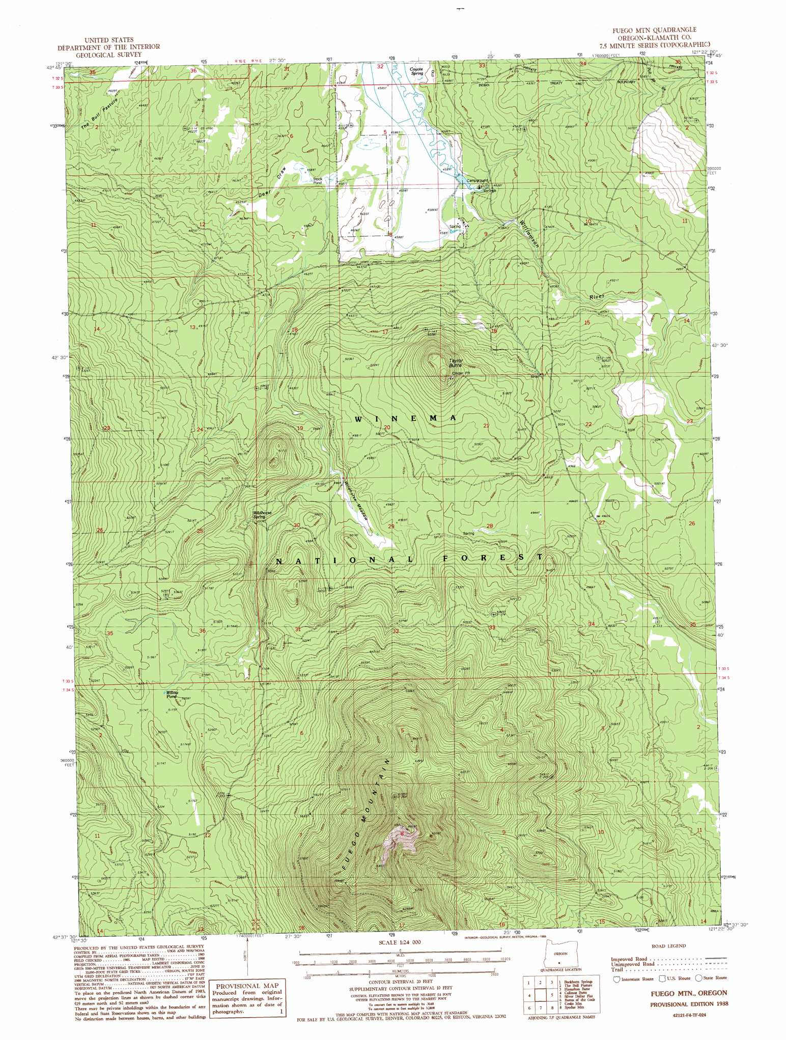
USGS Topo Quad 42121f4 - 1:24,000 scale
| Topo Map Name: | Fuego Mountain |
| USGS Topo Quad ID: | 42121f4 |
| Print Size: | ca. 21 1/4" wide x 27" high |
| Southeast Coordinates: | 42.625° N latitude / 121.375° W longitude |
| Map Center Coordinates: | 42.6875° N latitude / 121.4375° W longitude |
| U.S. State: | OR |
| Filename: | o42121f4.jpg |
| Download Map JPG Image: | Fuego Mountain topo map 1:24,000 scale |
| Map Type: | Topographic |
| Topo Series: | 7.5´ |
| Map Scale: | 1:24,000 |
| Source of Map Images: | United States Geological Survey (USGS) |
| Alternate Map Versions: |
Fuego Mountain OR 1988, updated 1988 Download PDF Buy paper map Fuego Mountain OR 1998, updated 2000 Download PDF Buy paper map Fuego Mountain OR 2011 Download PDF Buy paper map Fuego Mountain OR 2014 Download PDF Buy paper map |
| FStopo: | US Forest Service topo Fuego Mountain is available: Download FStopo PDF Download FStopo TIF |
1:24,000 Topo Quads surrounding Fuego Mountain
Military Crossing |
Wildhorse Ridge |
Gordon Lake |
Yamsay Mountain |
Partin Butte |
Wocus Bay |
Buckhorn Springs |
The Bull Pasture |
Hamelton Butte |
Sycan Marsh West |
Applegate Butte |
Calimus Butte |
Fuego Mountain |
Silver Dollar Flat |
Riverbed Butte Spring |
S'Ocholis Canyon |
Buttes Of The Gods |
Cooks Mountain |
Spodue Mountain |
Ponina Butte |
Swan Lake Point |
Sprague River West |
Sprague River East |
Beatty |
Ferguson Mountain |
> Back to 42121e1 at 1:100,000 scale
> Back to 42120a1 at 1:250,000 scale
> Back to U.S. Topo Maps home
Fuego Mountain topo map: Gazetteer
Fuego Mountain: Flats
Wildhorse Meadow elevation 1493m 4898′Fuego Mountain: Reservoirs
Airstrip Pond elevation 1580m 5183′Wildhorse Reservoir elevation 1487m 4878′
Willow Pond elevation 1578m 5177′
Yamsi Reservoir elevation 1498m 4914′
Fuego Mountain: Springs
Coyote Spring elevation 1401m 4596′Wildhorse Spring elevation 1511m 4957′
Williamson River Spring elevation 1406m 4612′
Yamsay Spring elevation 1401m 4596′
Fuego Mountain: Summits
Fuego Mountain elevation 2080m 6824′Taylor Butte elevation 1650m 5413′
Fuego Mountain: Valleys
Deer Draw elevation 1401m 4596′Fuego Mountain digital topo map on disk
Buy this Fuego Mountain topo map showing relief, roads, GPS coordinates and other geographical features, as a high-resolution digital map file on DVD: