Thompson Reservoir Topo Map Oregon
To zoom in, hover over the map of Thompson Reservoir
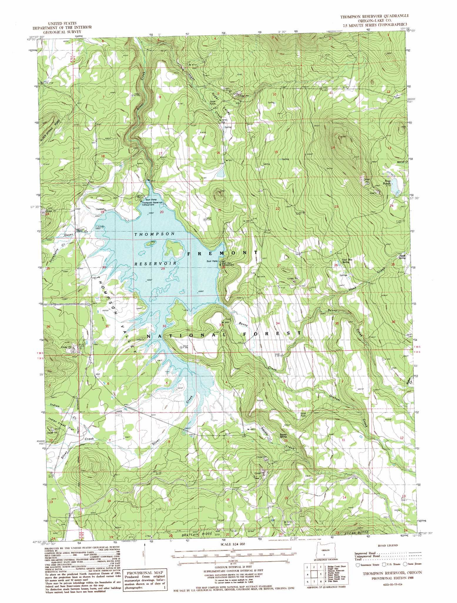
USGS Topo Quad 42121h1 - 1:24,000 scale
| Topo Map Name: | Thompson Reservoir |
| USGS Topo Quad ID: | 42121h1 |
| Print Size: | ca. 21 1/4" wide x 27" high |
| Southeast Coordinates: | 42.875° N latitude / 121° W longitude |
| Map Center Coordinates: | 42.9375° N latitude / 121.0625° W longitude |
| U.S. State: | OR |
| Filename: | o42121h1.jpg |
| Download Map JPG Image: | Thompson Reservoir topo map 1:24,000 scale |
| Map Type: | Topographic |
| Topo Series: | 7.5´ |
| Map Scale: | 1:24,000 |
| Source of Map Images: | United States Geological Survey (USGS) |
| Alternate Map Versions: |
Thompson Reservoir OR 1988, updated 1988 Download PDF Buy paper map Thompson Reservoir OR 2004, updated 2007 Download PDF Buy paper map Thompson Reservoir OR 2011 Download PDF Buy paper map Thompson Reservoir OR 2014 Download PDF Buy paper map |
| FStopo: | US Forest Service topo Thompson Reservoir is available: Download FStopo PDF Download FStopo TIF |
1:24,000 Topo Quads surrounding Thompson Reservoir
Antelope Mountain |
Oatman Flat |
Silver Lake |
Tuff Butte |
Thorn Lake |
Rodman Rock |
Bridge Creek Draw |
Hager Mountain |
Duncan Reservoir |
Egli Rim |
Yamsay Mountain |
Partin Butte |
Thompson Reservoir |
Foster Butte |
Summer Lake |
Hamelton Butte |
Sycan Marsh West |
Sycan Marsh East |
Pole Butte |
Fremont Point |
Silver Dollar Flat |
Riverbed Butte Spring |
Riverbed Butte |
Shake Butte |
Harvey Creek |
> Back to 42121e1 at 1:100,000 scale
> Back to 42120a1 at 1:250,000 scale
> Back to U.S. Topo Maps home
Thompson Reservoir topo map: Gazetteer
Thompson Reservoir: Dams
Thompson Dam elevation 1512m 4960′Thompson Reservoir: Lakes
Frog Ponds elevation 1762m 5780′Thompson Reservoir: Reservoirs
Thompson Reservoir elevation 1514m 4967′Thompson Reservoir: Springs
Hawk Spring elevation 1746m 5728′Squaw Spring elevation 1541m 5055′
Toolbox Spring elevation 1655m 5429′
Thompson Reservoir: Streams
Auger Creek elevation 1440m 4724′Benny Creek elevation 1513m 4963′
Graham Creek elevation 1525m 5003′
Guyer Creek elevation 1512m 4960′
Hawk Creek elevation 1585m 5200′
Indian Creek elevation 1523m 4996′
Squaw Creek elevation 1512m 4960′
Strawberry Creek elevation 1517m 4977′
Welker Creek elevation 1664m 5459′
Thompson Reservoir: Valleys
Auger Valley elevation 1534m 5032′Thompson Valley elevation 1512m 4960′
Thompson Reservoir digital topo map on disk
Buy this Thompson Reservoir topo map showing relief, roads, GPS coordinates and other geographical features, as a high-resolution digital map file on DVD: