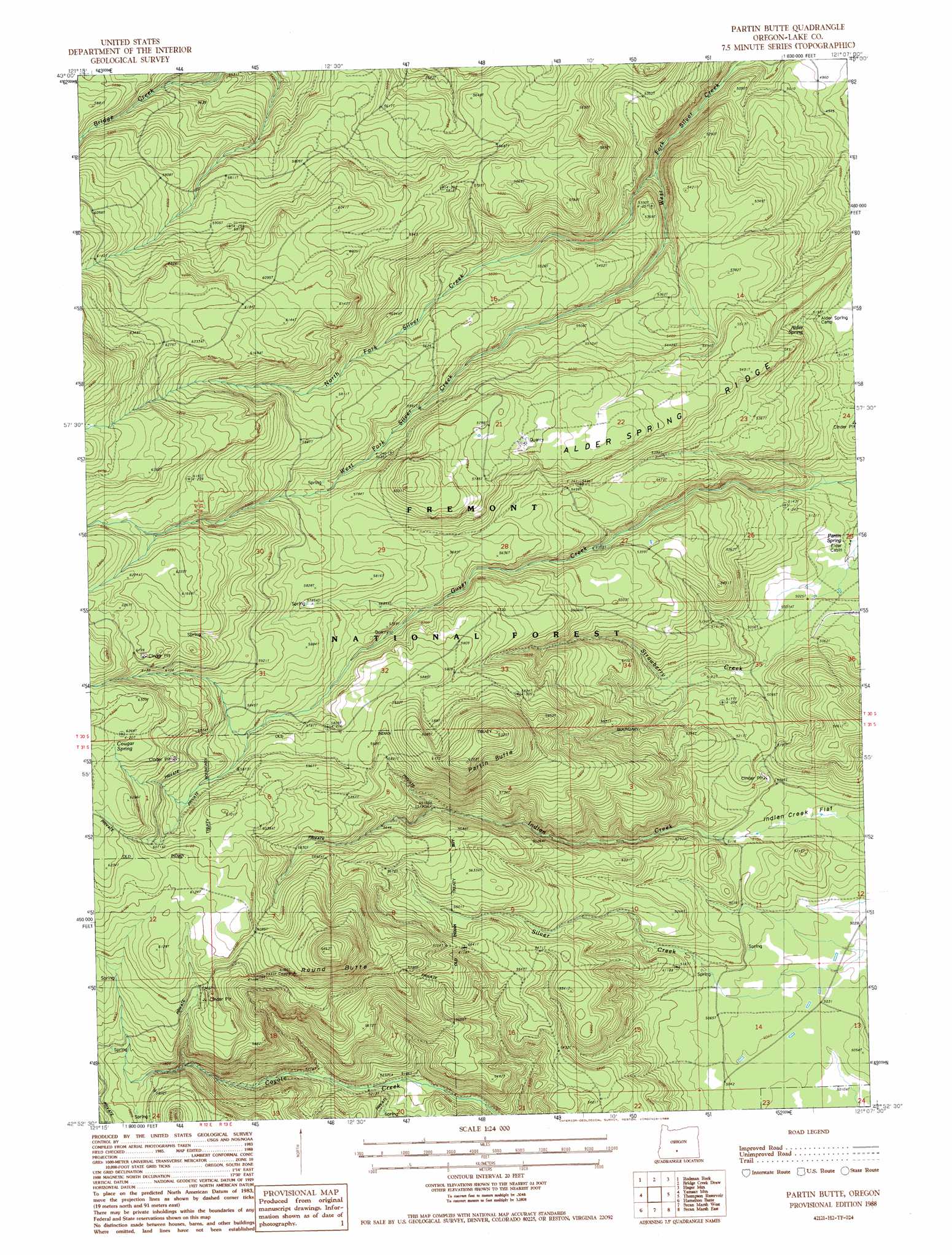
Partin Butte Topo Map Oregon
To zoom in, hover over the map of Partin Butte
USGS Topo Quad 42121h2 - 1:24,000 scale
| Topo Map Name: | Partin Butte |
| USGS Topo Quad ID: | 42121h2 |
| Print Size: | ca. 21 1/4" wide x 27" high |
| Southeast Coordinates: | 42.875° N latitude / 121.125° W longitude |
| Map Center Coordinates: | 42.9375° N latitude / 121.1875° W longitude |
| U.S. State: | OR |
| Filename: | o42121h2.jpg |
| Download Map JPG Image: | Partin Butte topo map 1:24,000 scale |
| Map Type: | Topographic |
| Topo Series: | 7.5´ |
| Map Scale: | 1:24,000 |
| Source of Map Images: | United States Geological Survey (USGS) |
| Alternate Map Versions: |
Partin Butte OR 1988, updated 1988 Download PDF Buy paper map Partin Butte OR 2004, updated 2007 Download PDF Buy paper map Partin Butte OR 2011 Download PDF Buy paper map Partin Butte OR 2014 Download PDF Buy paper map |
| FStopo: | US Forest Service topo Partin Butte is available: Download FStopo PDF Download FStopo TIF |
1:24,000 Topo Quads surrounding Partin Butte
Location Butte |
Antelope Mountain |
Oatman Flat |
Silver Lake |
Tuff Butte |
Bear Butte |
Rodman Rock |
Bridge Creek Draw |
Hager Mountain |
Duncan Reservoir |
Gordon Lake |
Yamsay Mountain |
Partin Butte |
Thompson Reservoir |
Foster Butte |
The Bull Pasture |
Hamelton Butte |
Sycan Marsh West |
Sycan Marsh East |
Pole Butte |
Fuego Mountain |
Silver Dollar Flat |
Riverbed Butte Spring |
Riverbed Butte |
Shake Butte |
> Back to 42121e1 at 1:100,000 scale
> Back to 42120a1 at 1:250,000 scale
> Back to U.S. Topo Maps home
Partin Butte topo map: Gazetteer
Partin Butte: Flats
Indian Creek Flat elevation 1540m 5052′Partin Butte: Ridges
Alder Spring Ridge elevation 1696m 5564′Partin Butte: Springs
Alder Spring elevation 1588m 5209′Partin Spring elevation 1523m 4996′
Partin Butte: Streams
North Fork Silver Creek elevation 1551m 5088′Partin Butte: Summits
Partin Butte elevation 1921m 6302′Round Butte elevation 1971m 6466′
Partin Butte digital topo map on disk
Buy this Partin Butte topo map showing relief, roads, GPS coordinates and other geographical features, as a high-resolution digital map file on DVD: