Siskiyou Pass Topo Map Oregon
To zoom in, hover over the map of Siskiyou Pass
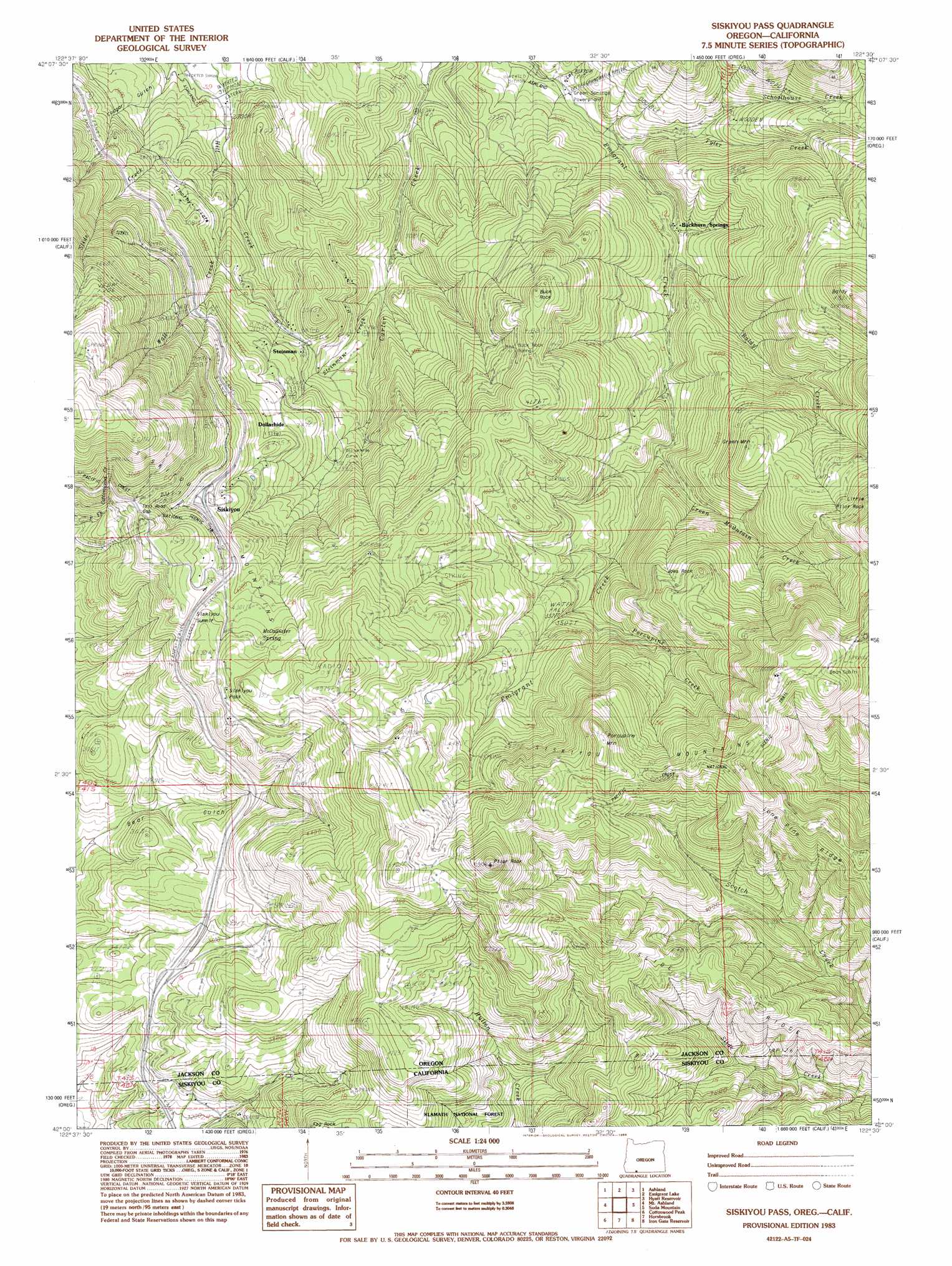
USGS Topo Quad 42122a5 - 1:24,000 scale
| Topo Map Name: | Siskiyou Pass |
| USGS Topo Quad ID: | 42122a5 |
| Print Size: | ca. 21 1/4" wide x 27" high |
| Southeast Coordinates: | 42° N latitude / 122.5° W longitude |
| Map Center Coordinates: | 42.0625° N latitude / 122.5625° W longitude |
| U.S. States: | OR, CA |
| Filename: | o42122a5.jpg |
| Download Map JPG Image: | Siskiyou Pass topo map 1:24,000 scale |
| Map Type: | Topographic |
| Topo Series: | 7.5´ |
| Map Scale: | 1:24,000 |
| Source of Map Images: | United States Geological Survey (USGS) |
| Alternate Map Versions: |
Siskiyou Pass OR 1983, updated 1983 Download PDF Buy paper map Siskiyou Pass OR 1983, updated 1988 Download PDF Buy paper map Siskiyou Pass OR 1983, updated 1988 Download PDF Buy paper map Siskiyou Pass OR 2001, updated 2004 Download PDF Buy paper map Siskiyou Pass OR 2012 Download PDF Buy paper map Siskiyou Pass OR 2014 Download PDF Buy paper map |
| FStopo: | US Forest Service topo Siskiyou Pass is available: Download FStopo PDF Download FStopo TIF |
1:24,000 Topo Quads surrounding Siskiyou Pass
Medford East |
Rio Canyon |
Grizzly Peak |
Robinson Butte |
Brown Mountain |
Talent |
Ashland |
Emigrant Lake |
Hyatt Reservoir |
Little Chinquapin Mountain |
Siskiyou Peak |
Mount Ashland |
Siskiyou Pass |
Soda Mountain |
Parker Mountain |
Buckhorn Bally |
Cottonwood Peak |
Hornbrook |
Iron Gate Reservoir |
Copco |
Mckinley Mountain |
Badger Mountain |
Hawkinsville |
Bogus Mountain |
Dewey Gulch |
> Back to 42122a1 at 1:100,000 scale
> Back to 42122a1 at 1:250,000 scale
> Back to U.S. Topo Maps home
Siskiyou Pass topo map: Gazetteer
Siskiyou Pass: Flats
Timothy Flats elevation 900m 2952′Siskiyou Pass: Gaps
Siskiyou Pass elevation 1369m 4491′Toll Road Gap elevation 1387m 4550′
Siskiyou Pass: Mines
Buck Rock Tunnel elevation 1113m 3651′Siskiyou Pass: Pillars
Buck Rock elevation 1261m 4137′Pilot Rock elevation 1759m 5770′
Siskiyou Pass: Populated Places
Buckhorn Springs elevation 810m 2657′Siskiyou Pass: Post Offices
Resort Post Office (historical) elevation 810m 2657′Siskiyou Post Office (historical) elevation 1246m 4087′
Soda Springs Post Office (historical) elevation 735m 2411′
Steinman Post Office (historical) elevation 948m 3110′
Siskiyou Pass: Reservoirs
Barrats Reservoir elevation 768m 2519′Porcupine Reservoir elevation 1539m 5049′
Siskiyou Pass: Ridges
Slide Ridge elevation 1249m 4097′Siskiyou Pass: Springs
Buckhorn Springs elevation 823m 2700′Dollarhide Spring elevation 1113m 3651′
McAllister Spring elevation 1370m 4494′
Powder Springs elevation 1302m 4271′
Shady Spring elevation 1172m 3845′
Siskiyou Pass: Streams
Baldy Creek elevation 825m 2706′Green Mountain Creek elevation 941m 3087′
North Fork Barron Creek elevation 765m 2509′
Porcupine Creek elevation 1048m 3438′
Schoolhouse Creek elevation 767m 2516′
Slide Creek elevation 717m 2352′
South Fork Barron Creek elevation 759m 2490′
Spring Creek elevation 1465m 4806′
Steinman Creek elevation 980m 3215′
Tyler Creek elevation 768m 2519′
Viaduct Creek elevation 979m 3211′
Wall Creek elevation 787m 2582′
West Branch Carter Creek elevation 1018m 3339′
Siskiyou Pass: Summits
Baldy elevation 1479m 4852′Green Mountain elevation 1297m 4255′
Joes Rock elevation 1399m 4589′
Little Pilot Rock elevation 1489m 4885′
Porcupine Mountain elevation 1605m 5265′
Siskiyou Pass: Valleys
Bear Gulch elevation 802m 2631′Cougar Gulch elevation 904m 2965′
Siskiyou Pass digital topo map on disk
Buy this Siskiyou Pass topo map showing relief, roads, GPS coordinates and other geographical features, as a high-resolution digital map file on DVD: