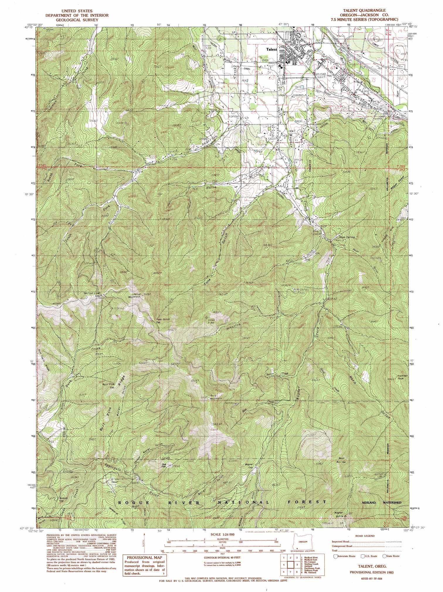
Talent Topo Map Oregon
To zoom in, hover over the map of Talent
USGS Topo Quad 42122b7 - 1:24,000 scale
| Topo Map Name: | Talent |
| USGS Topo Quad ID: | 42122b7 |
| Print Size: | ca. 21 1/4" wide x 27" high |
| Southeast Coordinates: | 42.125° N latitude / 122.75° W longitude |
| Map Center Coordinates: | 42.1875° N latitude / 122.8125° W longitude |
| U.S. State: | OR |
| Filename: | o42122b7.jpg |
| Download Map JPG Image: | Talent topo map 1:24,000 scale |
| Map Type: | Topographic |
| Topo Series: | 7.5´ |
| Map Scale: | 1:24,000 |
| Source of Map Images: | United States Geological Survey (USGS) |
| Alternate Map Versions: |
Talent OR 1983, updated 1983 Download PDF Buy paper map Talent OR 1996, updated 1998 Download PDF Buy paper map Talent OR 2011 Download PDF Buy paper map Talent OR 2014 Download PDF Buy paper map |
| FStopo: | US Forest Service topo Talent is available: Download FStopo PDF Download FStopo TIF |
1:24,000 Topo Quads surrounding Talent
Gold Hill |
Sams Valley |
Eagle Point |
Brownsboro |
Lakecreek |
Mount Isabelle |
Medford West |
Medford East |
Rio Canyon |
Grizzly Peak |
Ruch |
Sterling Creek |
Talent |
Ashland |
Emigrant Lake |
Squaw Lakes |
Dutchman Peak |
Siskiyou Peak |
Mount Ashland |
Siskiyou Pass |
Dutch Creek |
Condrey Mountain |
Buckhorn Bally |
Cottonwood Peak |
Hornbrook |
> Back to 42122a1 at 1:100,000 scale
> Back to 42122a1 at 1:250,000 scale
> Back to U.S. Topo Maps home
Talent topo map: Gazetteer
Talent: Canals
Frederick Lateral elevation 654m 2145′Upper West Lateral elevation 662m 2171′
West Lateral elevation 605m 1984′
Talent: Flats
Oak Flat elevation 951m 3120′Talent: Gaps
Bull Pine Gap elevation 1184m 3884′Duncan Gap elevation 1028m 3372′
Section Line Gap elevation 1315m 4314′
Wagner Gap elevation 1268m 4160′
Yank Gulch Gap elevation 1410m 4625′
Talent: Mines
Ashland Mine elevation 763m 2503′Talent: Populated Places
Talent elevation 496m 1627′Talent: Post Offices
Talent Post Office elevation 496m 1627′Talent: Reservoirs
Kerby Reservoir elevation 731m 2398′Talent: Ridges
Bull Pine Ridge elevation 1172m 3845′Talent: Slopes
Bear Wallow elevation 1683m 5521′Talent: Springs
Hope Spring elevation 876m 2874′Pollard Spring elevation 512m 1679′
Talent: Streams
Arrastra Creek elevation 768m 2519′Basin Creek elevation 935m 3067′
Glade Creek elevation 841m 2759′
Goose Creek elevation 871m 2857′
Holton Creek elevation 644m 2112′
Jeffery Creek elevation 478m 1568′
Myer Creek elevation 491m 1610′
North Fork Anderson Creek elevation 768m 2519′
South Fork Anderson Creek elevation 768m 2519′
Wagner Creek elevation 477m 1564′
Talent: Summits
Bald Mountain elevation 1682m 5518′Panther Peak elevation 1480m 4855′
Point Mountain elevation 1503m 4931′
Talent: Valleys
Bear Gulch elevation 784m 2572′First Water Gulch elevation 974m 3195′
Frazier Gulch elevation 882m 2893′
Horn Gulch elevation 872m 2860′
Mule Gulch elevation 983m 3225′
Packard Gulch elevation 552m 1811′
Phipps Gulch elevation 688m 2257′
Rail Gulch elevation 669m 2194′
Second Water Gulch elevation 950m 3116′
Skunk Gulch elevation 1004m 3293′
Water Gulch elevation 989m 3244′
Wildcat Canyon elevation 691m 2267′
Yank Gulch elevation 692m 2270′
Talent digital topo map on disk
Buy this Talent topo map showing relief, roads, GPS coordinates and other geographical features, as a high-resolution digital map file on DVD: