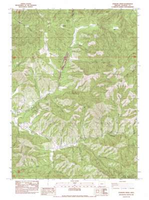
Sterling Creek Topo Map Oregon
To zoom in, hover over the map of Sterling Creek
USGS Topo Quad 42122b8 - 1:24,000 scale
| Topo Map Name: | Sterling Creek |
| USGS Topo Quad ID: | 42122b8 |
| Print Size: | ca. 21 1/4" wide x 27" high |
| Southeast Coordinates: | 42.125° N latitude / 122.875° W longitude |
| Map Center Coordinates: | 42.1875° N latitude / 122.9375° W longitude |
| U.S. State: | OR |
| Filename: | o42122b8.jpg |
| Download Map JPG Image: | Sterling Creek topo map 1:24,000 scale |
| Map Type: | Topographic |
| Topo Series: | 7.5´ |
| Map Scale: | 1:24,000 |
| Source of Map Images: | United States Geological Survey (USGS) |
| Alternate Map Versions: |
Sterling Creek OR 1983, updated 1983 Download PDF Buy paper map Sterling Creek OR 1996, updated 1998 Download PDF Buy paper map Sterling Creek OR 2011 Download PDF Buy paper map Sterling Creek OR 2014 Download PDF Buy paper map |
| FStopo: | US Forest Service topo Sterling Creek is available: Download FStopo PDF Download FStopo TIF |
1:24,000 Topo Quads surrounding Sterling Creek
> Back to 42122a1 at 1:100,000 scale
> Back to 42122a1 at 1:250,000 scale
> Back to U.S. Topo Maps home
Sterling Creek topo map: Gazetteer
Sterling Creek: Canals
Sterling Ditch elevation 755m 2477′Sterling Creek: Flats
Nelson Meadow elevation 930m 3051′Sterling Creek: Gaps
Wolf Gap elevation 1141m 3743′Sterling Creek: Mines
Sleppy Mine elevation 1217m 3992′Sterling Creek: Parks
Little Applegate Recreation Site elevation 774m 2539′Tunnel Ridge Recreation Site elevation 793m 2601′
Sterling Creek: Populated Places
Buncom elevation 513m 1683′Sterling Creek: Post Offices
Buncom Post Office (historical) elevation 513m 1683′Sterlingville Post Office (historical) elevation 833m 2732′
Sterling Creek: Reservoirs
Brown Reservoir elevation 582m 1909′Schlesinger Reservoir elevation 600m 1968′
Sterling Creek: Ridges
Goat Cabin Ridge elevation 1213m 3979′Tunnel Ridge elevation 957m 3139′
Sterling Creek: Streams
Birch Creek elevation 728m 2388′Blacksmith Creek elevation 755m 2477′
Grouse Creek elevation 524m 1719′
Little Lick Creek elevation 652m 2139′
Rush Creek elevation 799m 2621′
Sterling Creek elevation 507m 1663′
Trickle Creek elevation 832m 2729′
Yale Creek elevation 599m 1965′
Sterling Creek: Summits
Anderson Butte elevation 1523m 4996′Nelson Mountain elevation 1053m 3454′
Sterling Creek: Valleys
Armstrong Gulch elevation 649m 2129′Bear Gulch elevation 728m 2388′
Bear Hunt Gulch elevation 658m 2158′
Bray Gulch elevation 732m 2401′
Cantrall Gulch elevation 566m 1856′
Deep Gulch elevation 690m 2263′
Deming Gulch elevation 690m 2263′
Dutch Gulch elevation 824m 2703′
First Water Gulch elevation 623m 2043′
Gilson Gulch elevation 720m 2362′
Grub Gulch elevation 787m 2582′
Hopkins Gulch elevation 772m 2532′
Hukill Hollow elevation 632m 2073′
Left Fork Lick Gulch elevation 776m 2545′
Lick Gulch elevation 620m 2034′
McCormick Gulch elevation 597m 1958′
Miller Gulch elevation 843m 2765′
Muddy Gulch elevation 778m 2552′
Owl Gulch elevation 743m 2437′
Post Gulch elevation 899m 2949′
Sailor Gulch elevation 869m 2851′
Skate Gulch elevation 680m 2230′
Thunder Gulch elevation 644m 2112′
Waters Gulch elevation 651m 2135′
Wolf Gulch elevation 703m 2306′
Sterling Creek digital topo map on disk
Buy this Sterling Creek topo map showing relief, roads, GPS coordinates and other geographical features, as a high-resolution digital map file on DVD:


