Brown Mountain Topo Map Oregon
To zoom in, hover over the map of Brown Mountain
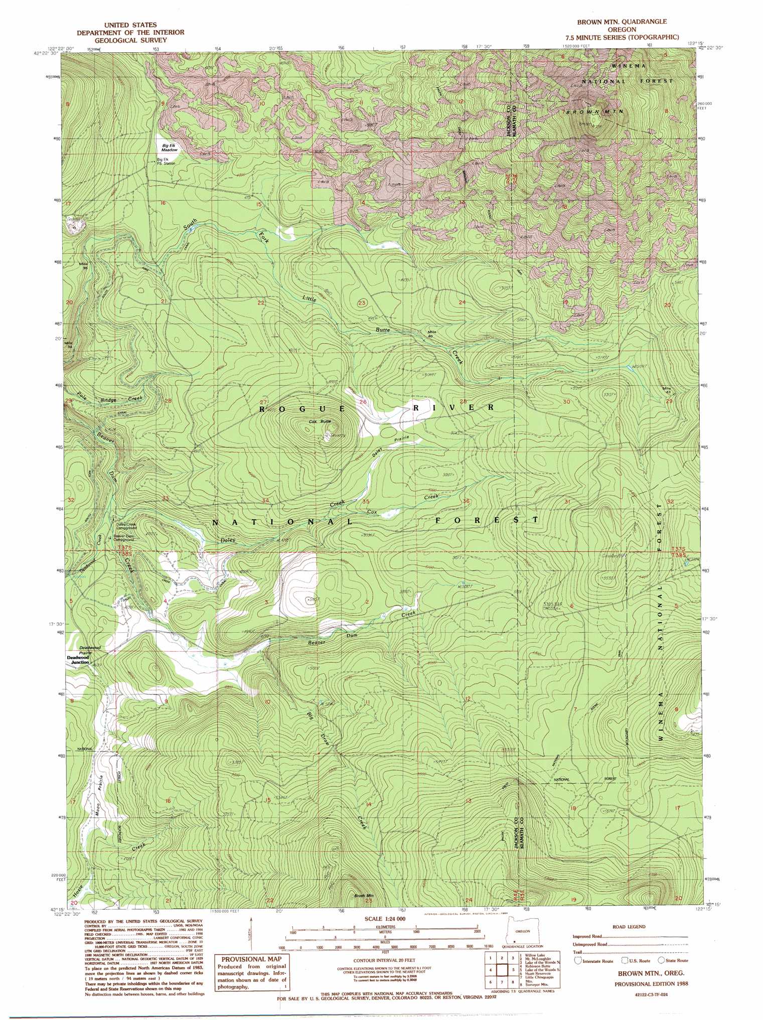
USGS Topo Quad 42122c3 - 1:24,000 scale
| Topo Map Name: | Brown Mountain |
| USGS Topo Quad ID: | 42122c3 |
| Print Size: | ca. 21 1/4" wide x 27" high |
| Southeast Coordinates: | 42.25° N latitude / 122.25° W longitude |
| Map Center Coordinates: | 42.3125° N latitude / 122.3125° W longitude |
| U.S. State: | OR |
| Filename: | o42122c3.jpg |
| Download Map JPG Image: | Brown Mountain topo map 1:24,000 scale |
| Map Type: | Topographic |
| Topo Series: | 7.5´ |
| Map Scale: | 1:24,000 |
| Source of Map Images: | United States Geological Survey (USGS) |
| Alternate Map Versions: |
Brown Mountain OR 1988, updated 1988 Download PDF Buy paper map Brown Mountain OR 1998, updated 2000 Download PDF Buy paper map Brown Mountain OR 2011 Download PDF Buy paper map Brown Mountain OR 2014 Download PDF Buy paper map |
| FStopo: | US Forest Service topo Brown Mountain is available: Download FStopo PDF Download FStopo TIF |
1:24,000 Topo Quads surrounding Brown Mountain
Butte Falls |
Big Butte Springs |
Rustler Peak |
Pelican Butte |
Crystal Spring |
Lakecreek |
Willow Lake |
Mount Mcloughlin |
Lake Of The Woods North |
Pelican Bay |
Grizzly Peak |
Robinson Butte |
Brown Mountain |
Lake Of The Woods South |
Aspen Lake |
Emigrant Lake |
Hyatt Reservoir |
Little Chinquapin Mountain |
Surveyor Mountain |
Spencer Creek |
Siskiyou Pass |
Soda Mountain |
Parker Mountain |
Mule Hill |
Chicken Hills |
> Back to 42122a1 at 1:100,000 scale
> Back to 42122a1 at 1:250,000 scale
> Back to U.S. Topo Maps home
Brown Mountain topo map: Gazetteer
Brown Mountain: Areas
Big Elk Meadow elevation 1429m 4688′Brown Mountain: Canals
Danley Creek Canal elevation 1433m 4701′South Fork Canal elevation 1422m 4665′
Brown Mountain: Dams
Daley Creek Dam elevation 1436m 4711′South Fork Dam elevation 1430m 4691′
Brown Mountain: Flats
Daley Prairie elevation 1520m 4986′Brown Mountain: Post Offices
Swastika Post Office (historical) elevation 1539m 5049′Brown Mountain: Reservoirs
Manley Reservoir elevation 1555m 5101′Brown Mountain: Streams
Big Draw Creek elevation 1457m 4780′Cox Creek elevation 1475m 4839′
Daley Creek elevation 1375m 4511′
Deadwood Creek elevation 1377m 4517′
Brown Mountain: Summits
Brown Mountain elevation 2228m 7309′Brush Mountain elevation 1861m 6105′
Cox Butte elevation 1632m 5354′
Brown Mountain: Trails
Brown Mountain Trail elevation 1631m 5351′Brown Mountain digital topo map on disk
Buy this Brown Mountain topo map showing relief, roads, GPS coordinates and other geographical features, as a high-resolution digital map file on DVD: