Rio Canyon Topo Map Oregon
To zoom in, hover over the map of Rio Canyon
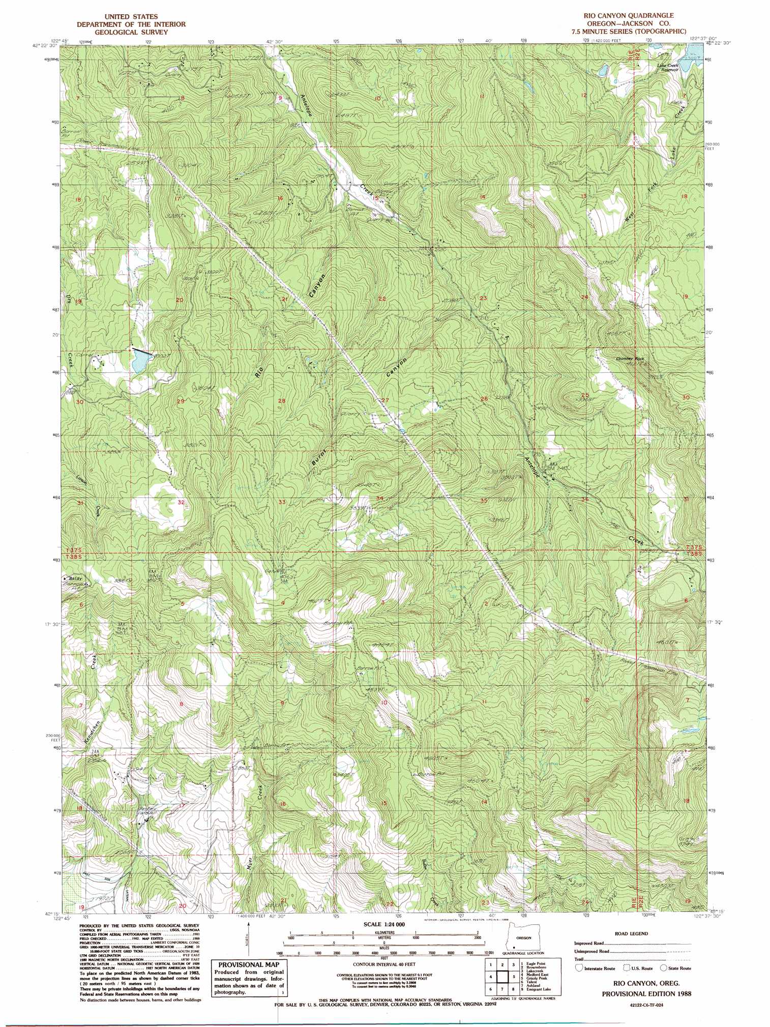
USGS Topo Quad 42122c6 - 1:24,000 scale
| Topo Map Name: | Rio Canyon |
| USGS Topo Quad ID: | 42122c6 |
| Print Size: | ca. 21 1/4" wide x 27" high |
| Southeast Coordinates: | 42.25° N latitude / 122.625° W longitude |
| Map Center Coordinates: | 42.3125° N latitude / 122.6875° W longitude |
| U.S. State: | OR |
| Filename: | o42122c6.jpg |
| Download Map JPG Image: | Rio Canyon topo map 1:24,000 scale |
| Map Type: | Topographic |
| Topo Series: | 7.5´ |
| Map Scale: | 1:24,000 |
| Source of Map Images: | United States Geological Survey (USGS) |
| Alternate Map Versions: |
Rio Canyon OR 1988, updated 1988 Download PDF Buy paper map Rio Canyon OR 2011 Download PDF Buy paper map Rio Canyon OR 2014 Download PDF Buy paper map |
1:24,000 Topo Quads surrounding Rio Canyon
Boswell Mountain |
Shady Cove |
Obenchain Mountain |
Butte Falls |
Big Butte Springs |
Sams Valley |
Eagle Point |
Brownsboro |
Lakecreek |
Willow Lake |
Medford West |
Medford East |
Rio Canyon |
Grizzly Peak |
Robinson Butte |
Sterling Creek |
Talent |
Ashland |
Emigrant Lake |
Hyatt Reservoir |
Dutchman Peak |
Siskiyou Peak |
Mount Ashland |
Siskiyou Pass |
Soda Mountain |
> Back to 42122a1 at 1:100,000 scale
> Back to 42122a1 at 1:250,000 scale
> Back to U.S. Topo Maps home
Rio Canyon topo map: Gazetteer
Rio Canyon: Canals
East Lateral elevation 625m 2050′Rio Canyon: Dams
Bradshaw Number 2 Dam elevation 718m 2355′Nelson Dam elevation 617m 2024′
Pierce Dam elevation 912m 2992′
Rio Canyon: Pillars
Chimney Rock elevation 1134m 3720′Rio Canyon: Reservoirs
Bradshaw Reservoir Number Two elevation 718m 2355′Brockway Reservoir elevation 743m 2437′
Lake Creek Reservoir elevation 702m 2303′
Nygren Reservoir elevation 791m 2595′
Pierce Reservoir elevation 912m 2992′
Wertz Reservoirs elevation 1501m 4924′
Rio Canyon: Springs
Rushing Spring elevation 1028m 3372′Rio Canyon: Streams
West Fork Lake Creek elevation 702m 2303′Rio Canyon: Summits
Taowhywee Point elevation 1136m 3727′Rio Canyon: Valleys
Burnt Canyon elevation 717m 2352′Rio Canyon elevation 710m 2329′
Rio Canyon digital topo map on disk
Buy this Rio Canyon topo map showing relief, roads, GPS coordinates and other geographical features, as a high-resolution digital map file on DVD: