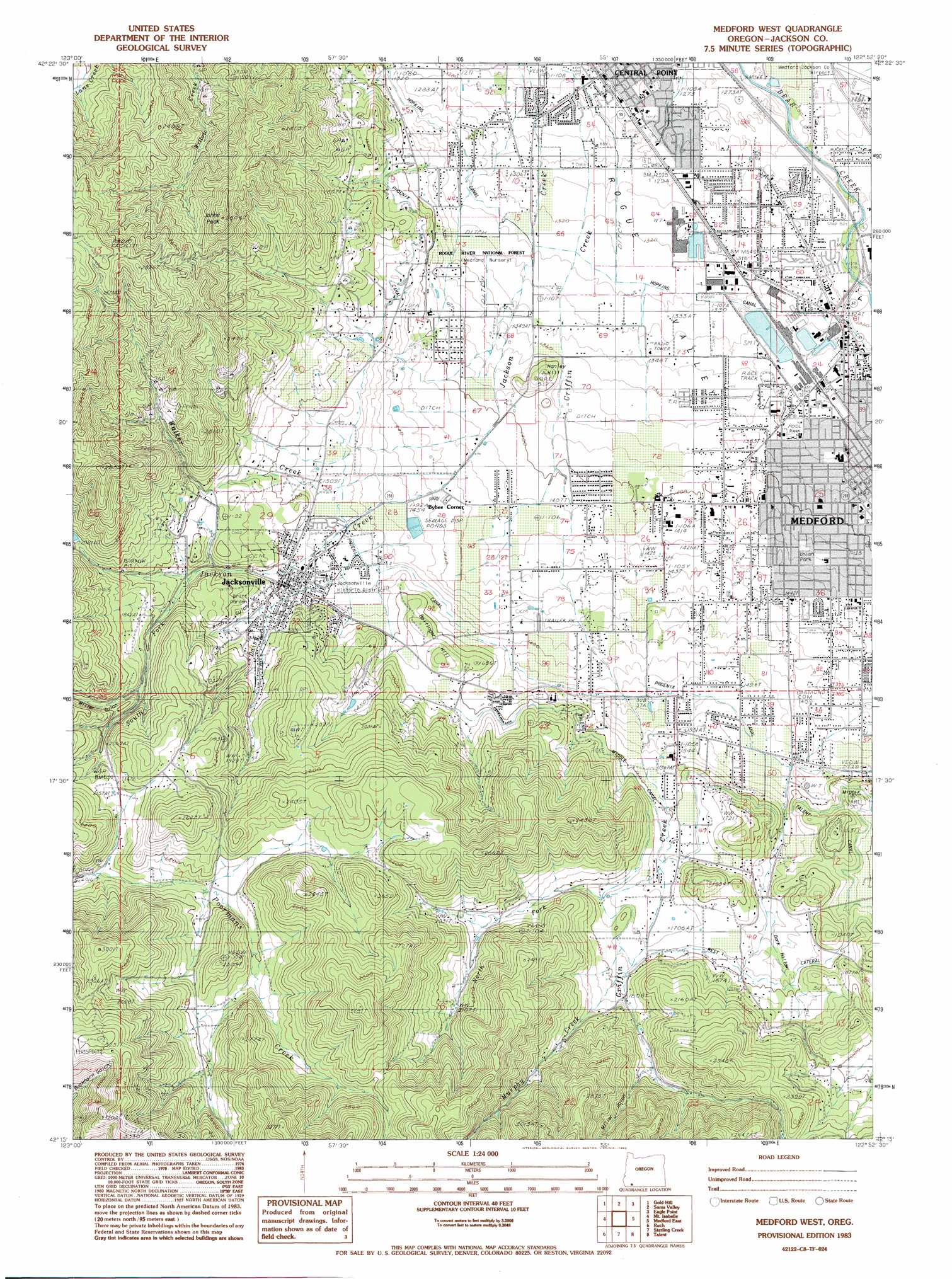
Medford West Topo Map Oregon
To zoom in, hover over the map of Medford West
USGS Topo Quad 42122c8 - 1:24,000 scale
| Topo Map Name: | Medford West |
| USGS Topo Quad ID: | 42122c8 |
| Print Size: | ca. 21 1/4" wide x 27" high |
| Southeast Coordinates: | 42.25° N latitude / 122.875° W longitude |
| Map Center Coordinates: | 42.3125° N latitude / 122.9375° W longitude |
| U.S. State: | OR |
| Filename: | o42122c8.jpg |
| Download Map JPG Image: | Medford West topo map 1:24,000 scale |
| Map Type: | Topographic |
| Topo Series: | 7.5´ |
| Map Scale: | 1:24,000 |
| Source of Map Images: | United States Geological Survey (USGS) |
| Alternate Map Versions: |
Medford SW OR 1974, updated 1981 Download PDF Buy paper map Medford West OR 1974, updated 1986 Download PDF Buy paper map Medford West OR 1983, updated 1983 Download PDF Buy paper map Medford West OR 2011 Download PDF Buy paper map Medford West OR 2014 Download PDF Buy paper map |
1:24,000 Topo Quads surrounding Medford West
Wimer |
Mcconville Peak |
Boswell Mountain |
Shady Cove |
Obenchain Mountain |
Rogue River |
Gold Hill |
Sams Valley |
Eagle Point |
Brownsboro |
Applegate |
Mount Isabelle |
Medford West |
Medford East |
Rio Canyon |
Tallowbox Mountain |
Ruch |
Sterling Creek |
Talent |
Ashland |
Carberry Creek |
Squaw Lakes |
Dutchman Peak |
Siskiyou Peak |
Mount Ashland |
> Back to 42122a1 at 1:100,000 scale
> Back to 42122a1 at 1:250,000 scale
> Back to U.S. Topo Maps home
Medford West topo map: Gazetteer
Medford West: Canals
Hopkins Canal elevation 406m 1332′Phoenix Canal elevation 461m 1512′
Medford West: Dams
Medford Forest Nursery Dam (historical) elevation 406m 1332′Timber Products Company Dam elevation 409m 1341′
Medford West: Parks
Britt Garden County Park elevation 517m 1696′Medford West: Populated Places
Bybee Corner elevation 452m 1482′Jacksonville elevation 477m 1564′
Medford elevation 421m 1381′
Perrydale (historical) elevation 437m 1433′
Medford West: Post Offices
Jacksonville Post Office elevation 477m 1564′Medford Post Office elevation 423m 1387′
Village Post Office (historical) elevation 439m 1440′
West Main Post Office elevation 429m 1407′
Medford West: Reservoirs
Goodrich Reservoir elevation 525m 1722′Hefferman Reservoir elevation 438m 1437′
Martin Reservoir elevation 556m 1824′
Medford Forest Nursery Reservoir (historical) elevation 406m 1332′
Minear Reservoir elevation 461m 1512′
Medford West: Streams
Daisy Creek elevation 447m 1466′Hanley Creek elevation 505m 1656′
Horn Creek elevation 411m 1348′
Murphy Creek elevation 537m 1761′
North Fork Griffin Creek elevation 516m 1692′
South Fork Jackson Creek elevation 510m 1673′
Walker Creek elevation 435m 1427′
Medford West: Summits
Bellinger Hill elevation 510m 1673′Hanley Hill elevation 432m 1417′
Jacksonville Hill elevation 797m 2614′
Johns Peak elevation 809m 2654′
Medford West: Valleys
Dark Hollow elevation 480m 1574′Hawk Gulch elevation 542m 1778′
Miller Gulch elevation 566m 1856′
Rich Gulch elevation 519m 1702′
Medford West digital topo map on disk
Buy this Medford West topo map showing relief, roads, GPS coordinates and other geographical features, as a high-resolution digital map file on DVD: