Lake Of The Woods North Topo Map Oregon
To zoom in, hover over the map of Lake Of The Woods North
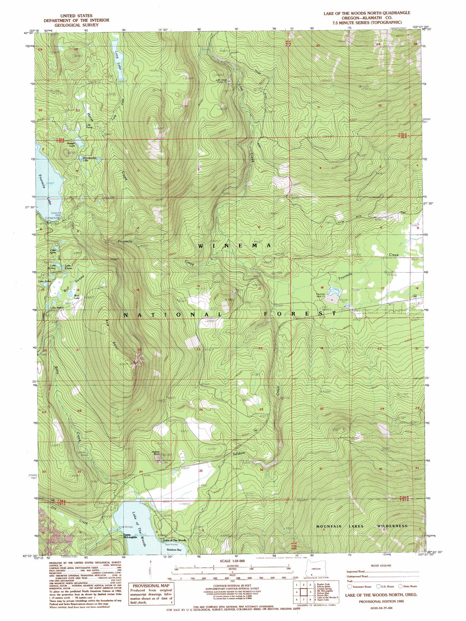
USGS Topo Quad 42122d2 - 1:24,000 scale
| Topo Map Name: | Lake Of The Woods North |
| USGS Topo Quad ID: | 42122d2 |
| Print Size: | ca. 21 1/4" wide x 27" high |
| Southeast Coordinates: | 42.375° N latitude / 122.125° W longitude |
| Map Center Coordinates: | 42.4375° N latitude / 122.1875° W longitude |
| U.S. State: | OR |
| Filename: | o42122d2.jpg |
| Download Map JPG Image: | Lake Of The Woods North topo map 1:24,000 scale |
| Map Type: | Topographic |
| Topo Series: | 7.5´ |
| Map Scale: | 1:24,000 |
| Source of Map Images: | United States Geological Survey (USGS) |
| Alternate Map Versions: |
Lake of The Woods North OR 1985, updated 1985 Download PDF Buy paper map Lake of The Woods North OR 1998, updated 2000 Download PDF Buy paper map Lake of the Woods North OR 2011 Download PDF Buy paper map Lake of the Woods North OR 2014 Download PDF Buy paper map |
| FStopo: | US Forest Service topo Lake of the Woods North is available: Download FStopo PDF Download FStopo TIF |
1:24,000 Topo Quads surrounding Lake Of The Woods North
Prospect South |
Imnaha Creek |
Devils Peak |
Mares Egg Spring |
Fort Klamath |
Big Butte Springs |
Rustler Peak |
Pelican Butte |
Crystal Spring |
Agency Lake |
Willow Lake |
Mount Mcloughlin |
Lake Of The Woods North |
Pelican Bay |
Shoalwater Bay |
Robinson Butte |
Brown Mountain |
Lake Of The Woods South |
Aspen Lake |
Howard Bay |
Hyatt Reservoir |
Little Chinquapin Mountain |
Surveyor Mountain |
Spencer Creek |
Keno |
> Back to 42122a1 at 1:100,000 scale
> Back to 42122a1 at 1:250,000 scale
> Back to U.S. Topo Maps home
Lake Of The Woods North topo map: Gazetteer
Lake Of The Woods North: Basins
Fourmile Flat Quarry elevation 1277m 4189′Lake Of The Woods North: Bays
Rainbow Bay elevation 1511m 4957′Lake Of The Woods North: Canals
Cascade Canal elevation 1747m 5731′Lake Of The Woods North: Dams
Fourmile Lake Dam elevation 1752m 5748′Lake Of The Woods North: Lakes
Budger Lake elevation 1797m 5895′Lake Aphis elevation 1792m 5879′
Lake Bernice elevation 1805m 5921′
Lake Clovis elevation 1804m 5918′
Lake Janice elevation 1791m 5875′
Lake Malice elevation 1783m 5849′
Lilly Pond elevation 1802m 5912′
Long Lake elevation 1844m 6049′
Wolf Lake elevation 1778m 5833′
Woodpecker Lake elevation 1793m 5882′
Lake Of The Woods North: Mines
Fourmile Rock Pit elevation 1278m 4192′Lost Creek Cinder Pit elevation 1654m 5426′
Lake Of The Woods North: Populated Places
Lake of the Woods elevation 1518m 4980′Lake Of The Woods North: Post Offices
Lake of the Woods Post Office (historical) elevation 1518m 4980′Lake Of The Woods North: Ridges
Rye Spur elevation 1908m 6259′Lake Of The Woods North: Streams
Billie Creek elevation 1511m 4957′Dry Creek elevation 1511m 4957′
Horse Creek elevation 1513m 4963′
Long Creek elevation 1787m 5862′
Lost Creek elevation 1329m 4360′
Seldom Creek elevation 1280m 4199′
Lake Of The Woods North: Summits
Pearce Point elevation 1585m 5200′Lake Of The Woods North: Swamps
Bull Swamp elevation 1780m 5839′Lake Of The Woods North: Trails
Four Mile Lake Trail elevation 1799m 5902′Greylock Mountain Trail elevation 1663m 5456′
Lost Peak Trail elevation 1970m 6463′
Rye Spur Trail elevation 1889m 6197′
Lake Of The Woods North digital topo map on disk
Buy this Lake Of The Woods North topo map showing relief, roads, GPS coordinates and other geographical features, as a high-resolution digital map file on DVD: