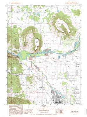
Sams Valley Topo Map Oregon
To zoom in, hover over the map of Sams Valley
USGS Topo Quad 42122d8 - 1:24,000 scale
| Topo Map Name: | Sams Valley |
| USGS Topo Quad ID: | 42122d8 |
| Print Size: | ca. 21 1/4" wide x 27" high |
| Southeast Coordinates: | 42.375° N latitude / 122.875° W longitude |
| Map Center Coordinates: | 42.4375° N latitude / 122.9375° W longitude |
| U.S. State: | OR |
| Filename: | o42122d8.jpg |
| Download Map JPG Image: | Sams Valley topo map 1:24,000 scale |
| Map Type: | Topographic |
| Topo Series: | 7.5´ |
| Map Scale: | 1:24,000 |
| Source of Map Images: | United States Geological Survey (USGS) |
| Alternate Map Versions: |
Medford NW OR 1974, updated 1978 Download PDF Buy paper map Sams Valley OR 1983, updated 1983 Download PDF Buy paper map Sams Valley OR 1983, updated 1995 Download PDF Buy paper map Sams Valley OR 2011 Download PDF Buy paper map Sams Valley OR 2014 Download PDF Buy paper map |
1:24,000 Topo Quads surrounding Sams Valley
> Back to 42122a1 at 1:100,000 scale
> Back to 42122a1 at 1:250,000 scale
> Back to U.S. Topo Maps home
Sams Valley topo map: Gazetteer
Sams Valley: Airports
Aeropuerto de los Banditos elevation 378m 1240′Roseburg Lumber Company Airstrip elevation 374m 1227′
Sams Valley: Bars
Salmon Rock elevation 397m 1302′Sams Valley: Bridges
Bybee Bridge (historical) elevation 366m 1200′Sams Valley: Canals
Coker Butte Lateral elevation 391m 1282′Table Rock Canal elevation 371m 1217′
Upton Lateral elevation 392m 1286′
Sams Valley: Dams
Duggan Dam elevation 380m 1246′Gold Ray Dam elevation 351m 1151′
Lester James Dam elevation 392m 1286′
Lester James Dam Number 3 elevation 381m 1250′
Skou Dam elevation 386m 1266′
Sams Valley: Flats
Bommers Flat elevation 496m 1627′Sams Valley: Guts
Kelly Slough elevation 352m 1154′Sams Valley: Lakes
Kendall Slough elevation 353m 1158′Lake of the Cedars elevation 376m 1233′
Modoc Pond elevation 365m 1197′
Sams Valley: Mines
Millionaire Mine elevation 515m 1689′Sams Valley: Parks
TouVelle State Park elevation 364m 1194′Sams Valley: Pillars
Lower Table Rock elevation 618m 2027′Sams Valley: Plains
Agate Desert elevation 383m 1256′Sams Valley: Populated Places
Central Point elevation 388m 1272′Four Corners elevation 393m 1289′
Sams Valley elevation 390m 1279′
Seven Oaks elevation 375m 1230′
Table Rock elevation 367m 1204′
Tolo elevation 365m 1197′
Sams Valley: Post Offices
Agate Post Office (historical) elevation 388m 1272′Central Point Post Office elevation 388m 1272′
Manseneta Post Office (historical) elevation 422m 1384′
Sams Valley Post Office (historical) elevation 390m 1279′
Table Rock Post Office (historical) elevation 367m 1204′
Tolo Post Office (historical) elevation 365m 1197′
Willow Springs Post Office (historical) elevation 426m 1397′
Sams Valley: Reservoirs
Dean Reservoir elevation 418m 1371′Gold Ray Reservoir elevation 351m 1151′
Harrison Reservoir elevation 393m 1289′
Hixson Reservoir elevation 458m 1502′
James Reservoir elevation 393m 1289′
Koellner Reservoir elevation 395m 1295′
Korner Reservoir elevation 389m 1276′
Lester James Reservoir elevation 392m 1286′
Lester James Reservoir Number 3 elevation 381m 1250′
Lomoha Reservoir elevation 380m 1246′
Marlin Reservoir elevation 358m 1174′
Martin Reservoir elevation 360m 1181′
McCormick Reservoir elevation 382m 1253′
Military Slough Reservoirs elevation 372m 1220′
Modoc Reservoirs elevation 400m 1312′
Morris Reservoir elevation 415m 1361′
Nelson Reservoir elevation 399m 1309′
Petrehn Reservoir elevation 379m 1243′
Quackenbush Reservoir elevation 391m 1282′
Skou Reservoir elevation 386m 1266′
Straus Reservoir elevation 393m 1289′
Sams Valley: Streams
Bear Creek elevation 356m 1167′Cliff Creek elevation 373m 1223′
Dean Creek elevation 372m 1220′
Griffin Creek elevation 372m 1220′
Jackson Creek elevation 364m 1194′
Lane Creek elevation 413m 1354′
Little Butte Creek elevation 367m 1204′
Middough Creek elevation 354m 1161′
Military Slough elevation 364m 1194′
Modoc Slough elevation 361m 1184′
Molby Creek elevation 367m 1204′
Snider Creek elevation 355m 1164′
Swanson Creek elevation 387m 1269′
Upton Slough elevation 353m 1158′
Whetstone Creek elevation 353m 1158′
Willow Creek elevation 362m 1187′
Zana Creek elevation 371m 1217′
Sams Valley: Summits
Upper Table Rock elevation 634m 2080′Sams Valley: Valleys
Curry Gulch elevation 390m 1279′Gold Gulch elevation 407m 1335′
Hidden Valley elevation 407m 1335′
Holman Gulch elevation 383m 1256′
Panther Gulch elevation 443m 1453′
Rogue Valley elevation 360m 1181′
Sams Valley digital topo map on disk
Buy this Sams Valley topo map showing relief, roads, GPS coordinates and other geographical features, as a high-resolution digital map file on DVD:


