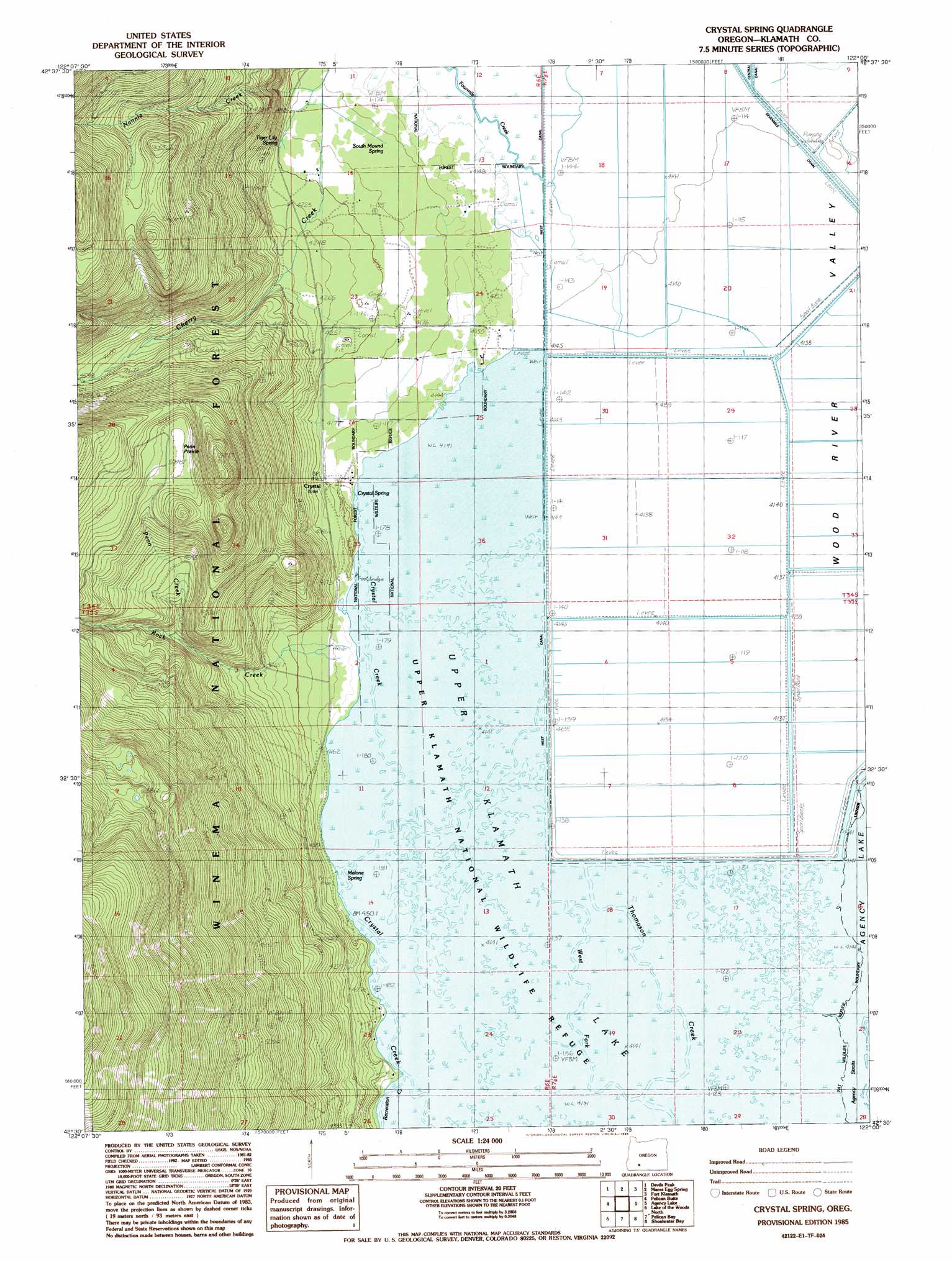
Crystal Spring Topo Map Oregon
To zoom in, hover over the map of Crystal Spring
USGS Topo Quad 42122e1 - 1:24,000 scale
| Topo Map Name: | Crystal Spring |
| USGS Topo Quad ID: | 42122e1 |
| Print Size: | ca. 21 1/4" wide x 27" high |
| Southeast Coordinates: | 42.5° N latitude / 122° W longitude |
| Map Center Coordinates: | 42.5625° N latitude / 122.0625° W longitude |
| U.S. State: | OR |
| Filename: | o42122e1.jpg |
| Download Map JPG Image: | Crystal Spring topo map 1:24,000 scale |
| Map Type: | Topographic |
| Topo Series: | 7.5´ |
| Map Scale: | 1:24,000 |
| Source of Map Images: | United States Geological Survey (USGS) |
| Alternate Map Versions: |
Crystal Spring OR 1985, updated 1985 Download PDF Buy paper map Crystal Spring OR 1998, updated 2000 Download PDF Buy paper map Crystal Spring OR 2011 Download PDF Buy paper map Crystal Spring OR 2014 Download PDF Buy paper map |
| FStopo: | US Forest Service topo Crystal Spring is available: Download FStopo PDF Download FStopo TIF |
1:24,000 Topo Quads surrounding Crystal Spring
Red Blanket Mountain |
Union Peak |
Maklaks Crater |
Sun Pass |
Fuego |
Imnaha Creek |
Devils Peak |
Mares Egg Spring |
Fort Klamath |
Soloman Butte |
Rustler Peak |
Pelican Butte |
Crystal Spring |
Agency Lake |
Chiloquin |
Mount Mcloughlin |
Lake Of The Woods North |
Pelican Bay |
Shoalwater Bay |
Modoc Point |
Brown Mountain |
Lake Of The Woods South |
Aspen Lake |
Howard Bay |
Wocus |
> Back to 42122e1 at 1:100,000 scale
> Back to 42122a1 at 1:250,000 scale
> Back to U.S. Topo Maps home
Crystal Spring topo map: Gazetteer
Crystal Spring: Canals
Fourmile Canal elevation 1264m 4146′Crystal Spring: Channels
Agency Straits elevation 1263m 4143′Crystal Spring: Levees
Sevenmile Canal Levee elevation 1263m 4143′Crystal Spring: Parks
Crystal Creek County Park elevation 1263m 4143′Upper Klamath National Wildlife Refuge elevation 1263m 4143′
Crystal Spring: Populated Places
Crystal (historical) elevation 1264m 4146′Crystal Spring: Post Offices
Crystal Post Office (historical) elevation 1264m 4146′Crystal Spring: Springs
Crystal Spring elevation 1263m 4143′Malone Spring elevation 1263m 4143′
South Mound Spring elevation 1272m 4173′
Tiger Lily Spring elevation 1554m 5098′
Crystal Spring: Streams
Fourmile Creek elevation 1262m 4140′Fourmile Slough elevation 1263m 4143′
Nannie Creek elevation 1279m 4196′
Penn Creek elevation 1374m 4507′
Rock Creek elevation 1318m 4324′
West Fork Thomason Creek elevation 1263m 4143′
Crystal Spring: Swamps
Penn Prairie elevation 1538m 5045′Crystal Spring: Trails
Pelican Butte Trail elevation 2010m 6594′Rocky Point Trail elevation 1786m 5859′
Crystal Spring digital topo map on disk
Buy this Crystal Spring topo map showing relief, roads, GPS coordinates and other geographical features, as a high-resolution digital map file on DVD: