Pelican Butte Topo Map Oregon
To zoom in, hover over the map of Pelican Butte
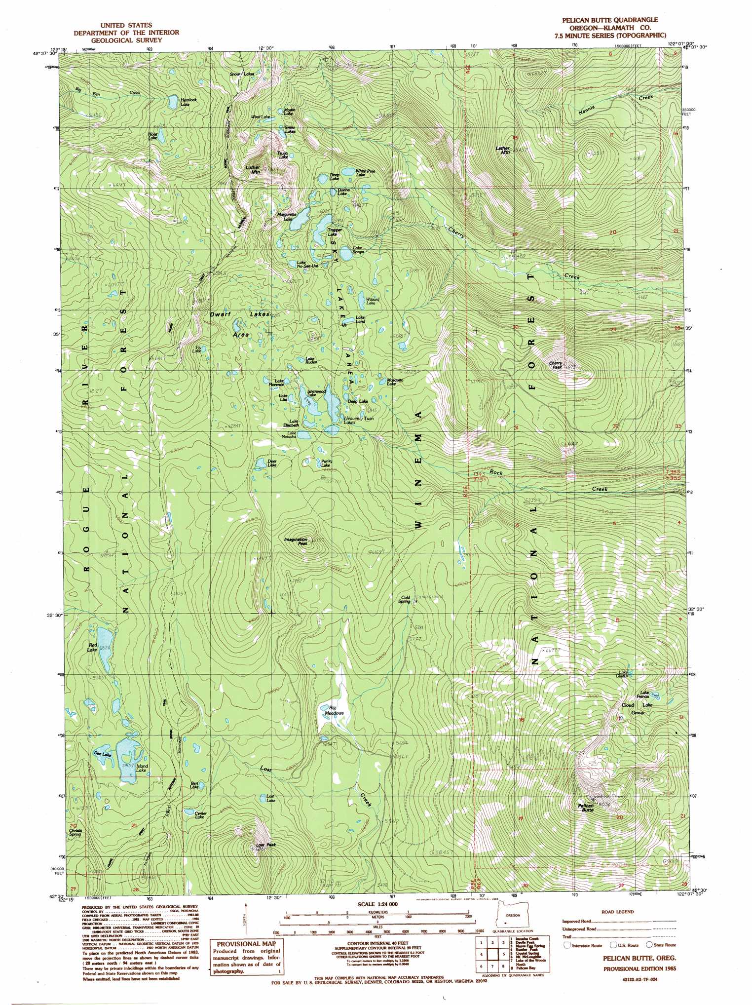
USGS Topo Quad 42122e2 - 1:24,000 scale
| Topo Map Name: | Pelican Butte |
| USGS Topo Quad ID: | 42122e2 |
| Print Size: | ca. 21 1/4" wide x 27" high |
| Southeast Coordinates: | 42.5° N latitude / 122.125° W longitude |
| Map Center Coordinates: | 42.5625° N latitude / 122.1875° W longitude |
| U.S. State: | OR |
| Filename: | o42122e2.jpg |
| Download Map JPG Image: | Pelican Butte topo map 1:24,000 scale |
| Map Type: | Topographic |
| Topo Series: | 7.5´ |
| Map Scale: | 1:24,000 |
| Source of Map Images: | United States Geological Survey (USGS) |
| Alternate Map Versions: |
Pelican Butte OR 1985, updated 1985 Download PDF Buy paper map Pelican Butte OR 1998, updated 2000 Download PDF Buy paper map Pelican Butte OR 2011 Download PDF Buy paper map Pelican Butte OR 2014 Download PDF Buy paper map |
| FStopo: | US Forest Service topo Pelican Butte is available: Download FStopo PDF Download FStopo TIF |
1:24,000 Topo Quads surrounding Pelican Butte
Prospect North |
Red Blanket Mountain |
Union Peak |
Maklaks Crater |
Sun Pass |
Prospect South |
Imnaha Creek |
Devils Peak |
Mares Egg Spring |
Fort Klamath |
Big Butte Springs |
Rustler Peak |
Pelican Butte |
Crystal Spring |
Agency Lake |
Willow Lake |
Mount Mcloughlin |
Lake Of The Woods North |
Pelican Bay |
Shoalwater Bay |
Robinson Butte |
Brown Mountain |
Lake Of The Woods South |
Aspen Lake |
Howard Bay |
> Back to 42122e1 at 1:100,000 scale
> Back to 42122a1 at 1:250,000 scale
> Back to U.S. Topo Maps home
Pelican Butte topo map: Gazetteer
Pelican Butte: Areas
Dwarf Lakes Area elevation 1891m 6204′Sky Lakes Area elevation 1815m 5954′
Pelican Butte: Lakes
Bert Lake elevation 1816m 5958′Center Lake elevation 1815m 5954′
Cloud Lake Group elevation 2166m 7106′
Dee Lake elevation 1808m 5931′
Deep Lake elevation 1815m 5954′
Deep Lake elevation 1824m 5984′
Deer Lake elevation 1854m 6082′
Donna Lake elevation 1806m 5925′
Fly Lake elevation 1915m 6282′
Heavenly Twin Lakes elevation 1825m 5987′
Hemlock Lake elevation 1864m 6115′
Holst Lake elevation 1877m 6158′
Isherwood Lake elevation 1828m 5997′
Island Lake elevation 1804m 5918′
Lake Elizabeth elevation 1830m 6003′
Lake Florence elevation 1857m 6092′
Lake Francis elevation 1984m 6509′
Lake Gladys elevation 2042m 6699′
Lake Hunice elevation 1941m 6368′
Lake Land elevation 1828m 5997′
Lake Liza elevation 1839m 6033′
Lake No-Se-Um elevation 1905m 6250′
Lake Notasha elevation 1838m 6030′
Lake Ruden elevation 1839m 6033′
Lake Sonya elevation 1791m 5875′
Lost Lake elevation 1790m 5872′
Margurette Lake elevation 1829m 6000′
Martin Lake elevation 1843m 6046′
Mosquito Lake elevation 1823m 5980′
Punky Lake elevation 1829m 6000′
Red Lake elevation 1775m 5823′
Snow Lakes elevation 2031m 6663′
Snow Lakes elevation 1856m 6089′
Trapper Lake elevation 1815m 5954′
Tsuga Lake elevation 1888m 6194′
White Pine Lake elevation 1787m 5862′
Wind Lake elevation 1853m 6079′
Wizzard Lake elevation 1817m 5961′
Pelican Butte: Parks
Island Lake Campground (historical) elevation 1803m 5915′Red Lake Campground (historical) elevation 1775m 5823′
South Island Campground (historical) elevation 1806m 5925′
Pelican Butte: Springs
Cold Spring elevation 1785m 5856′Pelican Butte: Summits
Cherry Peak elevation 2003m 6571′Imagination Peak elevation 1980m 6496′
Lather Mountain elevation 2102m 6896′
Lost Peak elevation 2052m 6732′
Luther Mountain elevation 2171m 7122′
Pelican Butte elevation 2440m 8005′
Pelican Butte: Swamps
Big Meadows elevation 1724m 5656′Pelican Butte: Trails
Cold Spring Trail elevation 1852m 6076′Nannie Creek Trail elevation 1816m 5958′
Red Lake Trail elevation 1868m 6128′
Wickiup Trail elevation 1834m 6017′
Pelican Butte digital topo map on disk
Buy this Pelican Butte topo map showing relief, roads, GPS coordinates and other geographical features, as a high-resolution digital map file on DVD: