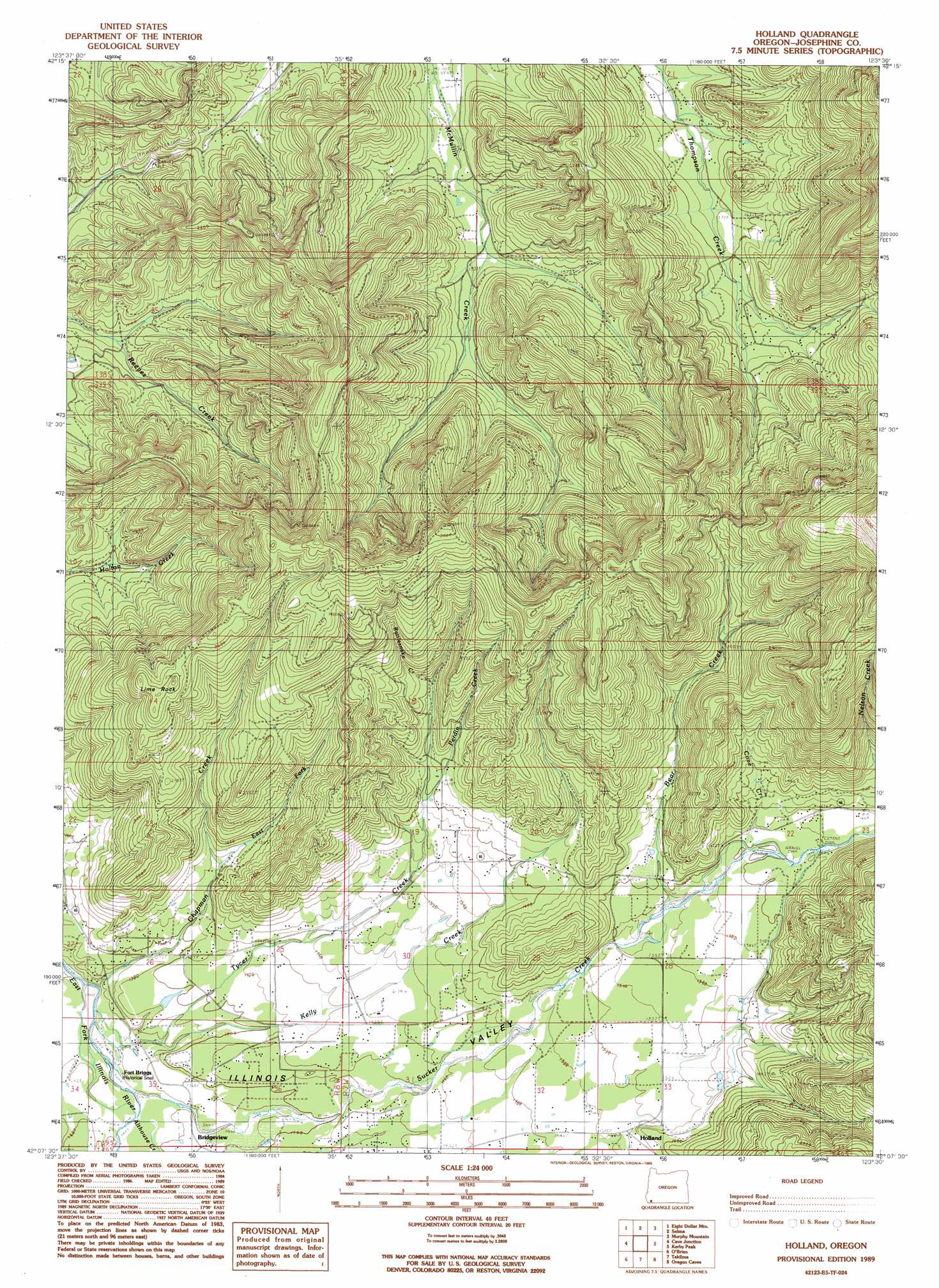
Holland Topo Map Oregon
To zoom in, hover over the map of Holland
USGS Topo Quad 42123b5 - 1:24,000 scale
| Topo Map Name: | Holland |
| USGS Topo Quad ID: | 42123b5 |
| Print Size: | ca. 21 1/4" wide x 27" high |
| Southeast Coordinates: | 42.125° N latitude / 123.5° W longitude |
| Map Center Coordinates: | 42.1875° N latitude / 123.5625° W longitude |
| U.S. State: | OR |
| Filename: | o42123b5.jpg |
| Download Map JPG Image: | Holland topo map 1:24,000 scale |
| Map Type: | Topographic |
| Topo Series: | 7.5´ |
| Map Scale: | 1:24,000 |
| Source of Map Images: | United States Geological Survey (USGS) |
| Alternate Map Versions: |
Holland OR 1989, updated 1989 Download PDF Buy paper map Holland OR 1996, updated 1999 Download PDF Buy paper map Holland OR 2011 Download PDF Buy paper map Holland OR 2014 Download PDF Buy paper map |
| FStopo: | US Forest Service topo Holland is available: Download FStopo PDF Download FStopo TIF |
1:24,000 Topo Quads surrounding Holland
York Butte |
Chrome Ridge |
Onion Mountain |
Wilderville |
Grants Pass |
Pearsoll Peak |
Eight Dollar Mountain |
Selma |
Murphy Mountain |
Murphy |
Josephine Mountain |
Cave Junction |
Holland |
Kerby Peak |
Williams |
Buckskin Peak |
O'Brien |
Takilma |
Oregon Caves |
Grayback Mountain |
Shelly Creek Ridge |
Broken Rib Mountain |
Polar Bear Mountain |
Deadman Point |
Figurehead Mountain |
> Back to 42123a1 at 1:100,000 scale
> Back to 42122a1 at 1:250,000 scale
> Back to U.S. Topo Maps home
Holland topo map: Gazetteer
Holland: Pillars
Lime Rock elevation 734m 2408′Holland: Populated Places
Althouse (historical) elevation 435m 1427′Bridgeview elevation 417m 1368′
Holland elevation 460m 1509′
Holland: Post Offices
Aloysius Post Office (historical) elevation 454m 1489′Althouse Post Office (historical) elevation 435m 1427′
Holland Post Office (historical) elevation 460m 1509′
Holland: Springs
Horse Spring elevation 423m 1387′Holland: Streams
Althouse Creek elevation 411m 1348′Bear Creek elevation 476m 1561′
Brown Slough elevation 446m 1463′
Chapman Creek elevation 402m 1318′
Cove Creek elevation 488m 1601′
East Fork Chapman Creek elevation 451m 1479′
Haven Creek elevation 490m 1607′
Kelly Creek elevation 404m 1325′
Little Bear Creek elevation 569m 1866′
Payne Slough elevation 434m 1423′
Perdin Creek elevation 506m 1660′
Rattlesnake Creek elevation 556m 1824′
Ryan Creek elevation 445m 1459′
Sawyer Slough elevation 434m 1423′
Sucker Creek elevation 410m 1345′
Tycer Creek elevation 410m 1345′
Holland: Valleys
Green Gulch elevation 525m 1722′Mulvaney Gulch elevation 470m 1541′
Peterson Gulch elevation 484m 1587′
Holland digital topo map on disk
Buy this Holland topo map showing relief, roads, GPS coordinates and other geographical features, as a high-resolution digital map file on DVD: