Josephine Mountain Topo Map Oregon
To zoom in, hover over the map of Josephine Mountain
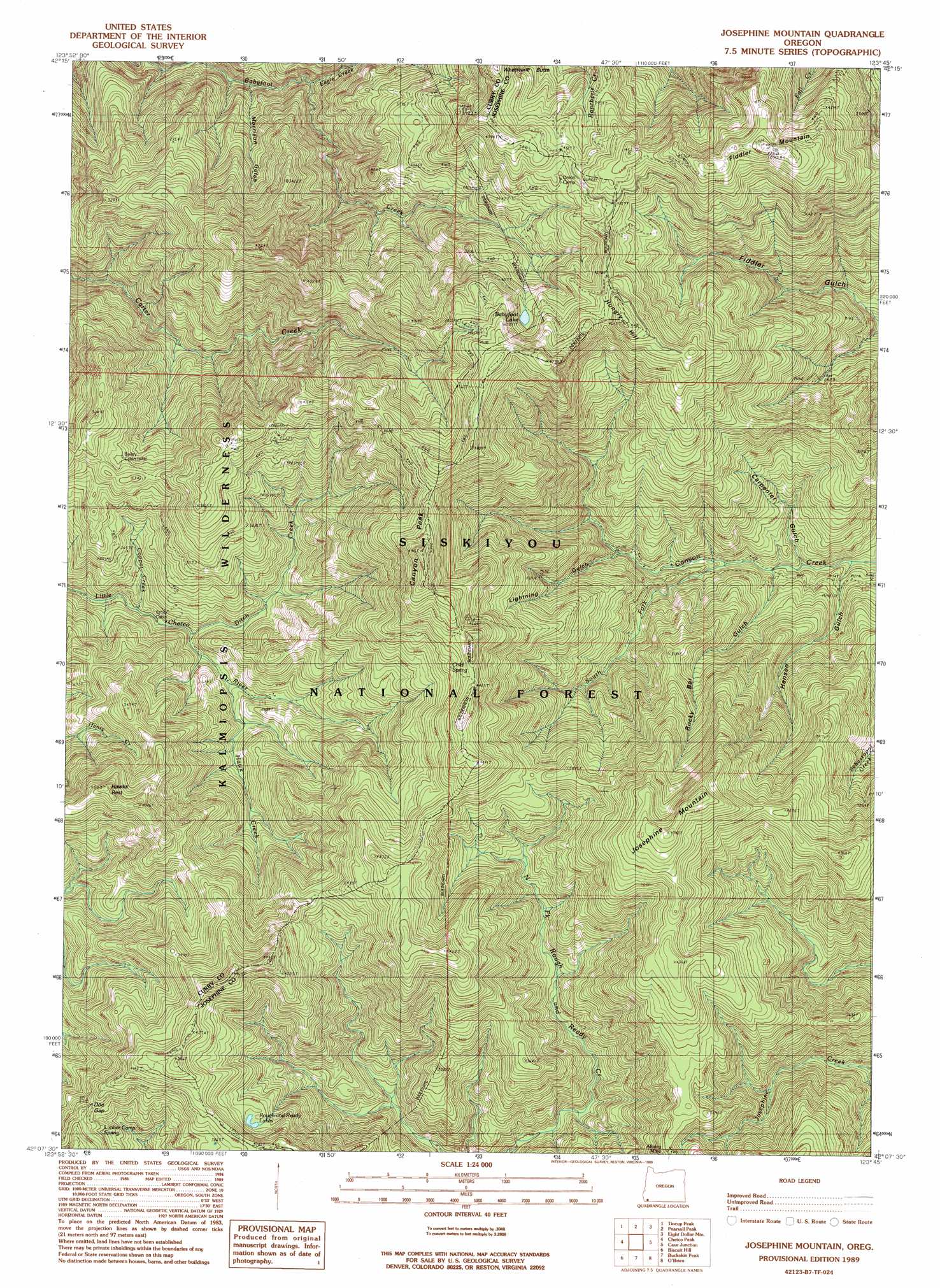
USGS Topo Quad 42123b7 - 1:24,000 scale
| Topo Map Name: | Josephine Mountain |
| USGS Topo Quad ID: | 42123b7 |
| Print Size: | ca. 21 1/4" wide x 27" high |
| Southeast Coordinates: | 42.125° N latitude / 123.75° W longitude |
| Map Center Coordinates: | 42.1875° N latitude / 123.8125° W longitude |
| U.S. State: | OR |
| Filename: | o42123b7.jpg |
| Download Map JPG Image: | Josephine Mountain topo map 1:24,000 scale |
| Map Type: | Topographic |
| Topo Series: | 7.5´ |
| Map Scale: | 1:24,000 |
| Source of Map Images: | United States Geological Survey (USGS) |
| Alternate Map Versions: |
Josephine Mountain OR 1989, updated 1989 Download PDF Buy paper map Josephine Mountain OR 1998, updated 2001 Download PDF Buy paper map Josephine Mountain OR 2011 Download PDF Buy paper map Josephine Mountain OR 2014 Download PDF Buy paper map |
| FStopo: | US Forest Service topo Josephine Mountain is available: Download FStopo PDF Download FStopo TIF |
1:24,000 Topo Quads surrounding Josephine Mountain
Horse Sign Butte |
Silver Peak |
York Butte |
Chrome Ridge |
Onion Mountain |
Big Craggies |
Tincup Peak |
Pearsoll Peak |
Eight Dollar Mountain |
Selma |
Quail Prairie Mountain |
Chetco Peak |
Josephine Mountain |
Cave Junction |
Holland |
Fourth Of July Creek |
Biscuit Hill |
Buckskin Peak |
O'Brien |
Takilma |
High Divide |
High Plateau Mountain |
Shelly Creek Ridge |
Broken Rib Mountain |
Polar Bear Mountain |
> Back to 42123a1 at 1:100,000 scale
> Back to 42122a1 at 1:250,000 scale
> Back to U.S. Topo Maps home
Josephine Mountain topo map: Gazetteer
Josephine Mountain: Gaps
Doe Gap elevation 1144m 3753′Josephine Mountain: Lakes
Babyfoot Lake elevation 1242m 4074′Rough and Ready Lakes elevation 1107m 3631′
Josephine Mountain: Mines
Alberg Mine elevation 1162m 3812′Babyfoot Mine elevation 1240m 4068′
Josephine Mountain: Parks
Babyfoot Lake Area elevation 1205m 3953′Josephine Mountain: Springs
Cold Spring elevation 1250m 4101′Limber Camp Spring elevation 1121m 3677′
Josephine Mountain: Streams
Copper Creek elevation 734m 2408′Ditch Creek elevation 698m 2290′
Eagle Creek elevation 656m 2152′
Hawk Creek elevation 769m 2522′
South Fork Canyon Creek elevation 609m 1998′
Josephine Mountain: Summits
Canyon Peak elevation 1436m 4711′Fiddler Mountain elevation 1490m 4888′
Hawks Rest elevation 1147m 3763′
Hungry Hill elevation 1359m 4458′
Josephine Mountain elevation 1404m 4606′
Josephine Mountain: Valleys
Carpenter Gulch elevation 599m 1965′Hansen Gulch elevation 529m 1735′
Lightning Gulch elevation 664m 2178′
Morrison Gulch elevation 584m 1916′
Rocky Bar Gulch elevation 574m 1883′
Josephine Mountain digital topo map on disk
Buy this Josephine Mountain topo map showing relief, roads, GPS coordinates and other geographical features, as a high-resolution digital map file on DVD: